Login
Register


CDS
Childress Municipal Airport
Official FAA Data Effective 2024-04-18 0901Z
Chart Supplement

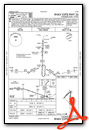
VFR Chart of KCDS
Sectional Charts at SkyVector.com
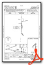
IFR Chart of KCDS
Enroute Charts at SkyVector.com
Location Information for KCDS
Coordinates: N34°26.03' / W100°17.28'Located 04 miles W of Childress, Texas on 2500 acres of land. View all Airports in Texas.
Surveyed Elevation is 1953 feet MSL.
Operations Data
|
|
Airport Communications
| ASOS: | 135.125 Tel. 940-937-6337 |
|---|---|
| CTAF: | 122.800 |
| UNICOM: | 122.800 |
| AWOS-3PT at VUF (47.9 S): | 120.20 806-596-4616 |
| AWOS-3PT at AXS (49.4 E): | 118.825 580-477-1745 |
| AWOS-3 at F05 (51.3 E): | 118.525 940-552-8600 |
- APCH/DEP CTL SVC PRVDD BY FORT WORTH ARTCC (ZFW) ON FREQS 133.5/350.35 (PADUCAH RCAG).
Nearby Navigation Aids
|
| ||||||||||||||||||||||||||||||||||||||||||||||||


Runway 18/36
| Dimensions: | 5949 x 75 feet / 1813 x 23 meters | |
|---|---|---|
| Surface: | Asphalt in Good Condition | |
| Weight Limits: | S-21 | |
| Edge Lighting: | Medium Intensity NSTD MIRL RWY 36 THLD LGTS 60 FT SOUTH OF RWY END. | |
| Runway 18 | Runway 36 | |
| Coordinates: | N34°26.42' / W100°17.13' | N34°25.44' / W100°17.17' |
| Elevation: | 1948.8 | 1953.8 |
| Traffic Pattern: | Left | Left |
| Runway Heading: | 182° True | 2° True |
| Markings: | Non-Precision Instrument in fair condition. | Non-Precision Instrument in fair condition. |
| Glide Slope Indicator | P2L (3.00° Glide Path Angle) | P2L (3.00° Glide Path Angle) |
| Obstacles: | 25 ft Pole 1090 ft from runway, 396 ft left of center | |
Runway 04/22
CLSD INDEFLY. | ||
| Dimensions: | 4425 x 60 feet / 1349 x 18 meters | |
|---|---|---|
| Surface: | Asphalt in Poor Condition RWY NOT MNTND; LOOSE GRAVEL AND VEGETATION GROWING THROUGH THE PAVEMENT. | |
| Weight Limits: | S-21 | |
| Runway 04 | Runway 22 | |
| Coordinates: | N34°25.91' / W100°17.77' | N34°26.41' / W100°17.13' |
| Elevation: | 1941.6 | 1949.0 |
| Traffic Pattern: | Left | Left |
| Runway Heading: | 47° True | 227° True |
| Markings: | Basic in poor condition. | Basic in poor condition. |
Services Available
| Fuel: | 100LL (blue), Jet A-1+ |
|---|---|
| Transient Storage: | Tiedowns |
| Airframe Repair: | NOT AVAILABLE |
| Engine Repair: | NOT AVAILABLE |
| Bottled Oxygen: | NOT AVAILABLE |
| Bulk Oxygen: | NOT AVAILABLE |
| Other Services: | CROP DUSTING SERVICES |
Ownership Information
| Ownership: | Publicly owned | |
|---|---|---|
| Owner: | CITY OF CHILDRESS | |
| 315 COMMERCE STREET | ||
| CHILDRESS, TX 79201 | ||
| 940-937-3684 | ||
| Manager: | TIFFANY TULLY | |
| 15716 FM 164 | ||
| CHILDRESS, TX 79201 | ||
| 940-937-8309 | ||
Operational Statistics
| Single Engine Aircraft Based on Field: | 13 | Statistics collected for 12 month period ending 2023-11-16 | |
|---|---|---|---|
| Multi-Engine Aircraft Based on Field: | 1 | Annual Commercial Operations: | none |
| Jet Aircraft Based on Field: | none | Annual Commuter Operations: | none |
| Helicopters Based on Field: | 1 | Annual Air Taxi Operations: | none |
| Military Aircraft Based on Field: | none | Annual Military Operations: | 40 |
| Gliders Based on Field: | none | Annual GA Local Operations: | 2800 |
| Ultralights Based on Field: | 2 | Annual GA Itinerant Operations: | 1400 |
Other Remarks
- THIS AIRPORT HAS BEEN SURVEYED BY THE NATIONAL GEODETIC SURVEY.
- SOME TWYS ROUGH DUE TO GRASS & WEED ENCROACHMENT.
- AGRICULTURE OPNS NEAR ALL PAVED SFCS.
- FOR CD CTC FORT WORTH ARTCC AT 817-858-7584.
- RWY 18/36, NMRS LGTS MISG, OUT, INCOR COLOR OR ORIENTATION.
- 0LL 24 HR SELF SVC 100LL AND JET A+. FULL SVC JET A+ AVBL DURG OPRG HRS; AFT HRS CALL 940-937-8309.
- MIRL RWY 18/36 PRESET LOW INTST; TO INCR INTST ACTVT - CTAF.
Weather Minimums
Instrument Approach Procedure (IAP) Charts
Nearby Airports with Instrument Procedures
| ID | Name | Heading / Distance | ||
|---|---|---|---|---|
 |
3F6 | Dan E Richards Municipal Airport | 179° | 24.3 |
|
O35 | Hollis Municipal Airport | 049° | 24.9 |
|
2K4 | Scott Field Airport | 053° | 46.6 |
|
KAXS | Altus/Quartz Mountain Regional Airport | 071° | 49.7 |
|
F05 | Wilbarger County Airport | 103° | 51.4 |
|
KLTS | Altus AFB Airport | 074° | 52.5 |
|
41F | Floydada Municipal Airport | 243° | 58.0 |
|
T59 | Wheeler Municipal Airport | 004° | 61.1 |
|
KFDR | Frederick Regional Airport | 093° | 64.9 |
|
8F3 | Crosbyton Municipal Airport | 224° | 67.9 |
|
KHBR | Hobart Regional Airport | 061° | 69.6 |
|
60F | Seymour Municipal Airport | 132° | 69.5 |
Fuel Providers

Airport Images
Do you have a recent image of this airport? Upload it here!


