Login
Register


CEV
Mettel Field Airport
Official FAA Data Effective 2024-04-18 0901Z
Chart Supplement

VFR Chart of KCEV
Sectional Charts at SkyVector.com
IFR Chart of KCEV
Enroute Charts at SkyVector.com
Location Information for KCEV
Coordinates: N39°41.89' / W85°7.87'Located 03 miles N of Connersville, Indiana on 444 acres of land. View all Airports in Indiana.
Surveyed Elevation is 866 feet MSL.
Operations Data
|
|
Airport Communications
| AWOS-3: | 118.325 Tel. 765-827-6649 |
|---|---|
| COLUMBUS APPROACH: | 134.45 352.05 |
| COLUMBUS DEPARTURE: | 134.45 352.05 |
| IC: | 352.05 |
| CTAF: | 122.800 |
| UNICOM: | 122.800 |
| AWOS-3 at RID (13.8 E): | 121.225 765-983-1903 |
| AWOS-3 at UWL (14.1 NW): | 132.375 765-422-5701 |
| AWOS-3PT at OXD (19.8 SE): | 118.625 513-273-2032 |
Nearby Navigation Aids
|
| ||||||||||||||||||||||||||||||||||||||||||||||||||||||||||||


Runway 18/36
| Dimensions: | 6503 x 100 feet / 1982 x 30 meters | |
|---|---|---|
| Surface: | Asphalt / Grooved in Good Condition | |
| Weight Limits: | S-50, D-84 | |
| Edge Lighting: | Medium Intensity | |
| Runway 18 | Runway 36 | |
| Coordinates: | N39°42.45' / W85°7.84' | N39°41.37' / W85°7.85' |
| Elevation: | 866.2 | 862.0 |
| Traffic Pattern: | Left | Left |
| Runway Heading: | 180° True | 360° True |
| Markings: | Precision Instrument in fair condition. | Non-Precision Instrument in fair condition. |
| Glide Slope Indicator | P4L (3.00° Glide Path Angle) | P4L (3.00° Glide Path Angle) |
| Approach Lights: | MALSR 1,400 Foot Medium-intensity Approach Lighting System with runway alignment indicator lights. | |
| REIL: | Yes | Yes |
| Obstacles: | 90 ft Trees 3340 ft from runway, 300 ft left of center | |
Runway 04/22
| Dimensions: | 2601 x 100 feet / 793 x 30 meters | |
|---|---|---|
| Surface: | Turf in Good Condition | |
| Runway 04 | Runway 22 | |
| Coordinates: | N39°41.68' / W85°8.08' | N39°42.02' / W85°7.75' |
| Elevation: | 861.5 | 857.8 |
| Traffic Pattern: | Left | Left |
| Runway Heading: | 36° True | 216° True |
| Markings: | None | None |
Services Available
| Fuel: | 100LL (blue), Jet-A |
|---|---|
| Transient Storage: | Hangars,Tiedowns |
| Airframe Repair: | NOT AVAILABLE |
| Engine Repair: | NOT AVAILABLE |
| Bottled Oxygen: | NONE |
| Bulk Oxygen: | NONE |
| Other Services: | CROP DUSTING SERVICES,PILOT INSTRUCTION |
Ownership Information
| Ownership: | Publicly owned | |
|---|---|---|
| Owner: | CONNERSVILLE BOAC | |
| 500 AIRPORT DRIVE | ||
| CONNERSVILLE, IN 47331 | ||
| 765-825-5581 | ||
| Manager: | JEFF DUNGAN | |
| 500 AIRPORT DRIVE | ||
| CONNERSVILLE, IN 47331 | ||
| (765) 825-5581 | ||
Operational Statistics
| Single Engine Aircraft Based on Field: | 12 | Statistics collected for 12 month period ending 2022-12-31 | |
|---|---|---|---|
| Multi-Engine Aircraft Based on Field: | 1 | Annual Commercial Operations: | none |
| Jet Aircraft Based on Field: | none | Annual Commuter Operations: | none |
| Helicopters Based on Field: | none | Annual Air Taxi Operations: | 249 |
| Military Aircraft Based on Field: | none | Annual Military Operations: | 40 |
| Gliders Based on Field: | none | Annual GA Local Operations: | 3698 |
| Ultralights Based on Field: | none | Annual GA Itinerant Operations: | 4285 |
Other Remarks
- BIRDS & DEER ON & INVOF ARPT.
- COLUMBUS APCH CD (614) 338-8537.
- 0LL SELF SVC H24.
- ACTVT MALSR RWY 18; REIL RWY 18 & 36; MIRL RWY 18/36 - CTAF. MIRL RWY 18/36 PRESET LOW INTST; INCR INTST - CTAF.
Weather Minimums

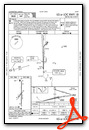
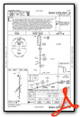
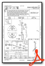
Instrument Approach Procedure (IAP) Charts
Nearby Airports with Instrument Procedures
| ID | Name | Heading / Distance | ||
|---|---|---|---|---|
 |
KRID | Richmond Municipal Airport | 075° | 13.8 |
|
KUWL | New Castle Henry County Marlatt Field Airport | 320° | 14.0 |
|
KOXD | Miami University Airport | 126° | 19.9 |
|
I34 | Greensburg Municipal Airport | 219° | 28.7 |
|
I22 | Randolph County Airport | 018° | 29.6 |
|
I67 | Cincinnati West Airport | 147° | 31.1 |
|
KGEZ | Shelbyville Municipal Airport | 257° | 32.0 |
|
KAID | Anderson Municipal-Darlington Field Airport | 318° | 33.2 |
|
KHAO | Butler County Regional/Hogan Field Airport | 125° | 34.7 |
|
KMIE | Delaware County Regional Airport | 339° | 34.8 |
|
KMWO | Middletown Regional/Hook Field Airport | 106° | 35.5 |
|
3I7 | Dayton/Phillipsburg Airport | 068° | 36.2 |
Airport Images
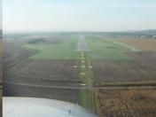
By: Pbergen


