Login
Register


CIC
Chico Regional Airport
Official FAA Data Effective 2024-04-18 0901Z
Chart Supplement

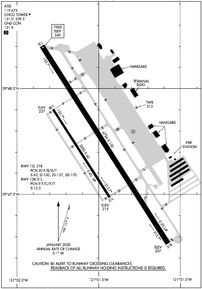
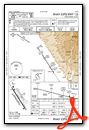
KCIC Airport Diagram
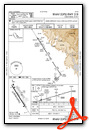
VFR Chart of KCIC
Sectional Charts at SkyVector.com
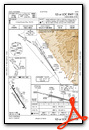
IFR Chart of KCIC
Enroute Charts at SkyVector.com
Location Information for KCIC
Coordinates: N39°47.72' / W121°51.51'Located 04 miles N of Chico, California on 1475 acres of land. View all Airports in California.
Surveyed Elevation is 240 feet MSL.
Operations Data
|
|
Airport Communications
| ATIS: | 119.675 |
|---|---|
| AWOS-3: | 119.675 Tel. 530-879-3850 |
| CHICO TOWER: | 121.0 239.3 |
| CHICO GROUND: | 121.9 |
| UNICOM: | 122.950 |
| CTAF: | 121.000 |
| ASOS at OVE (21.1 SE): | 121.425 530-533-5792 |
| ASOS at RBL (28.1 NW): | 120.775 530-528-8030 |
| AWOS-3 at O05 (40.9 NE): | 118.275 530-258-2860 |
- APCH/DEP CTL SVC PRVDD BY OAKLAND ARTCC (ZOA) ON FREQS 132.2/350.3 (RED BLUFF RCAG).
- EMERG FREQ 121.5 NOT AVBL.
Nearby Navigation Aids
|
| ||||||||||||||||||||||||||||||||||||


Runway 13L/31R
| Dimensions: | 6724 x 150 feet / 2049 x 46 meters | |
|---|---|---|
| Surface: | Asphalt / Grooved in Good Condition | |
| Weight Limits: | 20 /F/B/X/T, S-63, D-100, ST-170 | |
| Edge Lighting: | High Intensity | |
| Runway 13L | Runway 31R | |
| Coordinates: | N39°48.20' / W121°51.85' | N39°47.27' / W121°51.07' |
| Elevation: | 240.2 | 207.2 |
| Traffic Pattern: | Right | Left |
| Runway Heading: | 147° True | 327° True |
| Declared Distances: | TORA:6724 TODA:6724 ASDA:6724 LDA:6724 | TORA:6724 TODA:6724 ASDA:6724 LDA:6724 |
| Markings: | Precision Instrument in good condition. | Precision Instrument in good condition. |
| Glide Slope Indicator | P4L (3.00° Glide Path Angle) | V4L (3.00° Glide Path Angle) |
| Approach Lights: | MALSR 1,400 Foot Medium-intensity Approach Lighting System with runway alignment indicator lights. | |
| REIL: | Yes | |
Runway 13R/31L
| Dimensions: | 3000 x 60 feet / 914 x 18 meters | |
|---|---|---|
| Surface: | Asphalt in Fair Condition | |
| Weight Limits: | 9 /F/C/Y/T, S-12 | |
| Runway 13R | Runway 31L | |
| Coordinates: | N39°47.90' / W121°51.78' | N39°47.49' / W121°51.43' |
| Elevation: | 226.9 | 215.0 |
| Traffic Pattern: | Right | Left |
| Runway Heading: | 147° True | 327° True |
| Declared Distances: | TORA:3000 TODA:3000 ASDA:3000 LDA:3000 | TORA:3000 TODA:3000 ASDA:3000 LDA:3000 |
| Markings: | Basic in fair condition. | Basic in fair condition. |
Helipad H1
| Dimensions: | 64 x 64 feet / 20 x 20 meters | |
|---|---|---|
| Surface: | Concrete in Good Condition | |
| Weight Limits: | S-35 | |
Services Available
| Fuel: | 100LL (blue), Jet-A |
|---|---|
| Transient Storage: | Tiedowns |
| Airframe Repair: | MAJOR |
| Engine Repair: | MAJOR |
| Bottled Oxygen: | HIGH |
| Bulk Oxygen: | NOT AVAILABLE |
| Other Services: | AIR FREIGHT SERVICES,CROP DUSTING SERVICES,AVIONICS,CHARTER SERVICE,PILOT INSTRUCTION,AIRCRAFT RENTAL,AIRCRAFT SALES |
Ownership Information
| Ownership: | Publicly owned | |
|---|---|---|
| Owner: | CITY OF CHICO | |
| PO BOX 3420 | ||
| CHICO, CA 95927 | ||
| 530-896-7200 | ||
| Manager: | TOM BAHR | |
| 150 AIRPARK BLVD., SUITE 110 | ||
| CHICO, CA 95973 | ||
| 530-896-7216 | ||
Operational Statistics
| Single Engine Aircraft Based on Field: | 80 | Statistics collected for 12 month period ending 2023-01-06 | |
|---|---|---|---|
| Multi-Engine Aircraft Based on Field: | 11 | Annual Commercial Operations: | 21 |
| Jet Aircraft Based on Field: | 2 | Annual Commuter Operations: | none |
| Helicopters Based on Field: | 5 | Annual Air Taxi Operations: | 6719 |
| Military Aircraft Based on Field: | none | Annual Military Operations: | 1544 |
| Gliders Based on Field: | none | Annual GA Local Operations: | 6170 |
| Ultralights Based on Field: | none | Annual GA Itinerant Operations: | 19546 |
Other Remarks
- FOR JET/HVY ACFT OPER EAST OF FLD TPA 1500 FT AGL; FOR LGT ACFT OPER WEST & EAST OF FLD TPA 1000 FT AGL.
- BIRDS ON AND IN VCNTY OF ARPT.
- FUEL AVBL 0730-1900. FOR AFTER HRS FUEL CALL 530-588-4888.
- 0LL FOR FUEL AFT HRS CALL (530) 588-4888
- WHEN ATCT CLSD ACTVT MALSR RWY 13L; REIL RWY 31R; PAPI RWY 13L; VASI RWY 31R; HIRL RWY 13L/31R - CTAF.
Weather Minimums
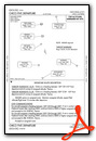
Instrument Approach Procedure (IAP) Charts
Departure Procedure (DP) Charts
Nearby Airports with Instrument Procedures
| ID | Name | Heading / Distance | ||
|---|---|---|---|---|
 |
O37 | Haigh Field Airport | 251° | 14.1 |
|
KOVE | Oroville Municipal Airport | 149° | 21.4 |
|
KWLW | Willows/Glenn County Airport | 224° | 23.6 |
|
KRBL | Red Bluff Municipal Airport | 319° | 28.0 |
|
O08 | Colusa County Airport | 189° | 37.5 |
|
KMYV | Yuba County Airport | 162° | 43.9 |
|
KBAB | Beale AFB Airport | 153° | 44.1 |
|
KRDD | Redding Regional Airport | 335° | 47.2 |
|
KGOO | Nevada County Airport | 130° | 52.5 |
|
O85 | Benton Field Airport | 331° | 53.1 |
|
KLHM | Lincoln Regional/Karl Harder Field Airport | 155° | 58.1 |
|
KAUN | Auburn Municipal Airport | 144° | 62.0 |
Airport Images

By: gyrosteve


