Login
Register


CKF
Crisp County-Cordele Airport
Official FAA Data Effective 2024-04-18 0901Z
Chart Supplement

VFR Chart of KCKF
Sectional Charts at SkyVector.com
IFR Chart of KCKF
Enroute Charts at SkyVector.com
Location Information for KCKF
Coordinates: N31°59.33' / W83°46.43'Located 02 miles NE of Cordele, Georgia on 619 acres of land. View all Airports in Georgia.
Surveyed Elevation is 309 feet MSL.
Operations Data
|
|
Airport Communications
| AWOS-3PT: | 119.325 Tel. 229-276-2669 |
|---|---|
| UNICOM: | 123.050 |
| CTAF: | 123.050 |
| AWOS-3 at ACJ (22.3 W): | 128.375 770-847-7993 |
| AWOS-3 at PXE (31.1 N): | 123.825 478-987-8768 |
| AWOS-3 at FZG (31.5 SE): | 118.625 229-426-5072 |
- APCH/DEP SVC PRVDD BY JACKSONVILLE ARTCC ON FREQS 125.75/363.075 (ALBANY RCAG).
Nearby Navigation Aids
|
| ||||||||||||||||||||||||||||||||||||||||||||||||||||||||||||


Runway 06/24
| Dimensions: | 5006 x 100 feet / 1526 x 30 meters | |
|---|---|---|
| Surface: | Asphalt in Good Condition | |
| Weight Limits: | S-24 | |
| Runway 06 | Runway 24 | |
| Coordinates: | N31°59.16' / W83°46.84' | N31°59.69' / W83°46.10' |
| Elevation: | 309.5 | 306.5 |
| Traffic Pattern: | Left | Right |
| Runway Heading: | 50° True | 230° True |
| Markings: | Non-Precision Instrument in good condition. | Non-Precision Instrument in good condition. |
| Obstacles: | 6 ft Tree 210 ft from runway, 56 ft left of center | 34 ft Trees 914 ft from runway, 180 ft left of center |
Runway 10/28
| Dimensions: | 5001 x 150 feet / 1524 x 46 meters | |
|---|---|---|
| Surface: | Asphalt in Good Condition | |
| Weight Limits: | S-30, D-45 | |
| Edge Lighting: | Medium Intensity | |
| Runway 10 | Runway 28 | |
| Coordinates: | N31°59.29' / W83°46.88' | N31°59.18' / W83°45.92' |
| Elevation: | 301.4 | 308.3 |
| Traffic Pattern: | Left | Right |
| Runway Heading: | 98° True | 278° True |
| Markings: | Non-Precision Instrument in good condition. | Non-Precision Instrument in good condition. |
| Glide Slope Indicator | P2L (3.00° Glide Path Angle) | P2L (3.00° Glide Path Angle) |
| Approach Lights: | ODALS Omnidirectional Approach Lighting System | |
| REIL: | Yes | Yes |
| Obstacles: | 41 ft Trees 774 ft from runway, 265 ft left of center | |
Services Available
| Fuel: | 100LL (blue), Jet A+ |
|---|---|
| Transient Storage: | Hangars,Tiedowns |
| Airframe Repair: | MAJOR |
| Engine Repair: | MAJOR |
| Bottled Oxygen: | NONE |
| Bulk Oxygen: | NONE |
| Other Services: | CROP DUSTING SERVICES,GLIDER SERVICE |
Ownership Information
| Ownership: | Publicly owned | |
|---|---|---|
| Owner: | CRISP COUNTY | |
| 210 7TH ST SOUTH | ||
| CORDELE, GA 31015 | ||
| 229-276-2672 | ||
| Manager: | SHERRIE LEGER LEVERETT | |
| 210 S 7TH STREET | ||
| CORDELE, GA 31015 | ||
| 229-276-2673 | ||
Operational Statistics
| Single Engine Aircraft Based on Field: | 13 | Statistics collected for 12 month period ending 2021-12-31 | |
|---|---|---|---|
| Multi-Engine Aircraft Based on Field: | 1 | Annual Commercial Operations: | none |
| Jet Aircraft Based on Field: | none | Annual Commuter Operations: | none |
| Helicopters Based on Field: | none | Annual Air Taxi Operations: | none |
| Military Aircraft Based on Field: | none | Annual Military Operations: | none |
| Gliders Based on Field: | none | Annual GA Local Operations: | 16000 |
| Ultralights Based on Field: | none | Annual GA Itinerant Operations: | 6000 |
Other Remarks
- FOR CD CTC JACKSONVILLE ARTCC AT 904-845-1592.
- MIRL RY 10/28 & PAPI RYS 10 & 28 PRESET ON LOW INTST DUSK-2200; TO INCR INTST & ACTVT AFT 2200 - CTAF. ACTVT ODALS RY 10 & REIL RY 10 & 28 - CTAF.
Weather Minimums

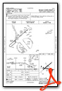
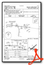
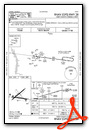
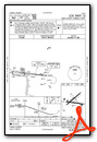
Instrument Approach Procedure (IAP) Charts

Nearby Airports with Instrument Procedures
| ID | Name | Heading / Distance | ||
|---|---|---|---|---|
 |
75J | Turner County Airport | 158° | 19.4 |
|
53A | Dr C P Savage Sr Airport | 327° | 22.3 |
|
KACJ | Jimmy Carter Regional Airport | 289° | 22.4 |
|
KPXE | Perry-Houston County Airport | 000° | 31.2 |
|
KFZG | Fitzgerald Municipal Airport | 125° | 31.5 |
|
KABY | Southwest Georgia Regional Airport | 218° | 34.6 |
|
48A | Cochran Airport | 045° | 35.3 |
|
KEZM | Heart of Georgia Regional Airport | 067° | 35.6 |
|
KTMA | Henry Tift Myers Airport | 156° | 36.5 |
|
KWRB | Robins AFB Airport | 013° | 40.1 |
|
6A1 | Butler Municipal Airport | 325° | 42.2 |
|
KMCN | Middle Georgia Regional Airport | 008° | 42.6 |
Airport Images
Do you have a recent image of this airport? Upload it here!


