Login
Register


CKV
Outlaw Field Airport
Official FAA Data Effective 2024-04-18 0901Z
Chart Supplement

VFR Chart of KCKV
Sectional Charts at SkyVector.com
IFR Chart of KCKV
Enroute Charts at SkyVector.com
Location Information for KCKV
Coordinates: N36°37.31' / W87°24.90'Located 06 miles NW of Clarksville, Tennessee on 452 acres of land. View all Airports in Tennessee.
Surveyed Elevation is 549 feet MSL.
Operations Data
|
|
Airport Communications
| ASOS: | 134.575 Tel. 931-431-3045 |
|---|---|
| CAMPBELL APPROACH: | 134.35 307.025 363.8 |
| CAMPBELL DEPARTURE: | 134.35 307.025 |
| CTAF: | 122.800 |
| UNICOM: | 122.800 |
| AWOS-3 at EOD (4.5 SW): | 270-956-3100 |
| ATIS at EOD (4.6 SW): | 306.5 |
| ATIS at HOP (4.8 NW): | 125.175 |
Nearby Navigation Aids
|
| ||||||||||||||||||||||||||||||||||||||||||||||||||||||||||||


Runway 17/35
| Dimensions: | 5999 x 100 feet / 1828 x 30 meters | |
|---|---|---|
| Surface: | Asphalt in Excellent Condition | |
| Weight Limits: | 27 /R/C/X/T, S-60, D-90 | |
| Edge Lighting: | Medium Intensity | |
| Runway 17 | Runway 35 | |
| Coordinates: | N36°37.77' / W87°25.06' | N36°36.81' / W87°24.76' |
| Elevation: | 538.0 | 549.0 |
| Traffic Pattern: | Left | Right |
| Runway Heading: | 166° True | 346° True |
| Markings: | Non-Precision Instrument in good condition. | Non-Precision Instrument in good condition. |
| Glide Slope Indicator | P2L (3.00° Glide Path Angle) PAPI RWY 17 UNUSBL BYD 9 DEGS RIGHT OF CNTLN. | P2L (3.00° Glide Path Angle) |
| Approach Lights: | MALS 1,400 Foot Medium-intensity Approach Lighting System. | |
| REIL: | Yes | |
| Obstacles: | 103 ft Trees 2334 ft from runway, 463 ft left of center | 75 ft Trees 2156 ft from runway, 377 ft left of center |
Runway 05/23
| Dimensions: | 4004 x 100 feet / 1220 x 30 meters | |
|---|---|---|
| Surface: | Asphalt in Fair Condition | |
| Weight Limits: | S-40, D-60 | |
| Runway 05 | Runway 23 | |
| Coordinates: | N36°37.14' / W87°25.20' | N36°37.55' / W87°24.56' |
| Elevation: | 539.3 | 532.7 |
| Traffic Pattern: | Right | Left |
| Runway Heading: | 52° True | 232° True |
| Displaced Threshold: | 402 Feet | 503 Feet |
| Declared Distances: | TORA:4004 TODA:4004 ASDA:3501 LDA:3099 | TORA:4004 TODA:4004 ASDA:3602 LDA:3099 |
| Markings: | Non-Precision Instrument in poor condition. | Non-Precision Instrument in poor condition. |
| Obstacles: | 44 ft Tree 365 ft from runway, 63 ft right of center APCH RATIO 12:1 TO DSPLCD THR. FENCE 100 FT FM RWY END. |
86 ft Tree 1057 ft from runway, 28 ft left of center APCH RATIO 19:1 TO DSPLCD THR. FENCE 100 FT FM RWY END. |
Services Available
| Fuel: | 100LL (blue), Jet A+ |
|---|---|
| Transient Storage: | Hangars,Tiedowns |
| Airframe Repair: | MAJOR |
| Engine Repair: | MAJOR |
| Bottled Oxygen: | NOT AVAILABLE |
| Bulk Oxygen: | NOT AVAILABLE |
| Other Services: | AIR AMBULANCE SERVICES,PILOT INSTRUCTION,AIRCRAFT RENTAL |
Ownership Information
| Ownership: | Publicly owned | |
|---|---|---|
| Owner: | CLARKSVILLE MONTGOMERY COUNTY RAA | |
| 200 A OUTLAW FIELD ROAD | ||
| CLARKSVILLE, TN 37042 | ||
| 931-431-2080 | ||
| Manager: | JOHN PATTERSON | |
| 200 AIRPORT ROAD - BLDG 1 | ||
| CLARKSVILLE, TN 37042 | ||
| 931-431-2080 | ||
Operational Statistics
| Single Engine Aircraft Based on Field: | 66 | Statistics collected for 12 month period ending 2020-07-01 | |
|---|---|---|---|
| Multi-Engine Aircraft Based on Field: | 9 | Annual Commercial Operations: | none |
| Jet Aircraft Based on Field: | 2 | Annual Commuter Operations: | none |
| Helicopters Based on Field: | 10 | Annual Air Taxi Operations: | 1000 |
| Military Aircraft Based on Field: | none | Annual Military Operations: | 5475 |
| Gliders Based on Field: | none | Annual GA Local Operations: | 15000 |
| Ultralights Based on Field: | none | Annual GA Itinerant Operations: | 11000 |
Other Remarks
- EXTSV MIL & CIVIL FLIGHT TRNG WITHIN ARPT AREA.
- DEER ON & INVOF ARPT.
- FOR CD WHEN UNA VIA FREQ CTC CAMPBELL APCH AT 270-798-6441.
- PEELING & FADED.
- PEELING & FADED.
- 0LL AFT HR SVC - 931-217-8765.
- ACTVT MALS RWY 35; REIL RWY 17 - CTAF.
Weather Minimums
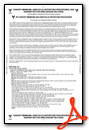
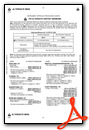
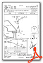
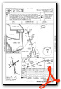
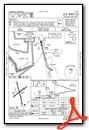
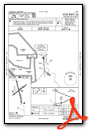
Instrument Approach Procedure (IAP) Charts
Nearby Airports with Instrument Procedures
| ID | Name | Heading / Distance | ||
|---|---|---|---|---|
 |
KHOP | Campbell AAF (Fort Campbell) Airport | 309° | 4.8 |
|
KHVC | Hopkinsville-Christian County Airport | 352° | 14.2 |
|
M91 | Springfield Robertson County Airport | 101° | 24.4 |
|
M02 | Dickson Municipal Airport | 181° | 29.6 |
|
4M7 | Russellville-Logan County Airport | 069° | 31.0 |
|
0M5 | Humphreys County Airport | 207° | 34.1 |
|
2M0 | Princeton-Caldwell County Airport | 324° | 36.4 |
|
KJWN | John C Tune Airport | 135° | 36.7 |
|
M21 | Muhlenberg County Airport | 018° | 38.3 |
|
2I0 | Madisonville Regional Airport | 001° | 44.0 |
|
1M5 | Douglas Hunter Field Airport | 091° | 45.3 |
|
KCEY | Kyle-Oakley Field Airport | 273° | 46.3 |
Airport Images

By: nblalock@clarks...


