Login
Register


CNK
Blosser Municipal Airport
Official FAA Data Effective 2024-04-18 0901Z
Chart Supplement

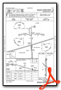
VFR Chart of KCNK
Sectional Charts at SkyVector.com
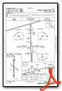
IFR Chart of KCNK
Enroute Charts at SkyVector.com
Location Information for KCNK
Coordinates: N39°32.99' / W97°39.12'Located 02 miles S of Concordia, Kansas on 209 acres of land. View all Airports in Kansas.
Surveyed Elevation is 1488 feet MSL.
Operations Data
|
|
Airport Communications
| ASOS: | 123.825 Tel. 785-243-3441 |
|---|---|
| UNICOM: | 122.800 |
| CTAF: | 122.800 |
| AWOS-3 at K61 (22.6 W): | 118.225 785-534-1141 |
| AWOS-3T at CYW (24.9 SE): | 119.95 785-777-2507 |
| AWOS-3 at HJH (36.1 N): | 118.525 402-768-2501 |
- APCH/DEP CTL SVC PRVDD BY KANSAS CITY ARTCC (ZKC) ON FREQS 134.9/363.2 (SALINA RCAG).
Nearby Navigation Aids
|
| ||||||||||||||||||||||||||||||||||||||||||||||||||||||||||||


Runway 18/36
| Dimensions: | 4000 x 75 feet / 1219 x 23 meters | |
|---|---|---|
| Surface: | Asphalt in Good Condition | |
| Weight Limits: | 5 /F/C/Y/U, S-8, D-10
OBTAINED EARLIER FM DESIGN CRITERIA DURING NEW CONSTRUCTION.
OBTAINED EARLIER FM DESIGN CRITERIA DURING NEW CONSTRUCTION.
| |
| Edge Lighting: | Medium Intensity | |
| Runway 18 | Runway 36 | |
| Coordinates: | N39°33.31' / W97°39.13' | N39°32.65' / W97°39.13' |
| Elevation: | 1475.6 | 1488.1 |
| Traffic Pattern: | Left | Left |
| Runway Heading: | 180° True | 360° True |
| Markings: | Non-Precision Instrument in good condition. | Non-Precision Instrument in good condition. |
| Glide Slope Indicator | P4L (3.00° Glide Path Angle) PAPI UNUSBL BYD 4 DEGS LEFT OF CNTRLN. | P4L (3.00° Glide Path Angle) PAPI UNUSBL BYD 6 DEGS LEFT OF CNTRLN. |
| REIL: | Yes | Yes |
| Obstacles: | 69 ft Tree 2010 ft from runway, 319 ft left of center | |
Runway 12/30
| Dimensions: | 2040 x 60 feet / 622 x 18 meters | |
|---|---|---|
| Surface: | Turf in Good Condition | |
| Runway 12 | Runway 30 | |
| Coordinates: | N39°33.12' / W97°39.27' | N39°32.89' / W97°38.95' |
| Elevation: | 1470.8 | 1456.3 |
| Traffic Pattern: | Left | Left |
| Runway Heading: | 132° True | 312° True |
| Markings: | None | None |
| Obstacles: | 17 ft Power Line 534 ft from runway | |
Services Available
| Fuel: | 100LL (blue), Jet A+ |
|---|---|
| Transient Storage: | Hangars,Tiedowns |
| Airframe Repair: | NOT AVAILABLE |
| Engine Repair: | NOT AVAILABLE |
| Bottled Oxygen: | NONE |
| Bulk Oxygen: | NONE |
| Other Services: | CROP DUSTING SERVICES |
Ownership Information
| Ownership: | Publicly owned | |
|---|---|---|
| Owner: | CITY OF CONCORDIA | |
| BOX 603 (CITY OFFICE) | ||
| CONCORDIA, KS 66901 | ||
| Manager: | RON COPPLE | |
| 701 WASHINGTON | ||
| CONCORDIA, KS 66901 | ||
| 785-243-2670 | ||
Operational Statistics
| Single Engine Aircraft Based on Field: | 12 | Statistics collected for 12 month period ending 2020-09-29 | |
|---|---|---|---|
| Multi-Engine Aircraft Based on Field: | 1 | Annual Commercial Operations: | none |
| Jet Aircraft Based on Field: | none | Annual Commuter Operations: | none |
| Helicopters Based on Field: | none | Annual Air Taxi Operations: | none |
| Military Aircraft Based on Field: | none | Annual Military Operations: | 400 |
| Gliders Based on Field: | none | Annual GA Local Operations: | 8000 |
| Ultralights Based on Field: | none | Annual GA Itinerant Operations: | 6150 |
Other Remarks
- <RDO CTLD MODEL AIRPLANE FLYING E OF ARPT TO 400' EVENINGS, WKENDS & HOL.
- PHONE AVBL 24 HRS.
- FOR CD CTC KANSAS CITY ARTCC AT 913-254-8508.
- 0LL FUEL AVBL 24 HRS BY CREDIT CARD.
- ACTVT REIL RWYS 18 & 36; PAPI RWY 18 & 36 - CTAF. MIRL RWY 18/36 PRESET MED INTST DUSK-2200; AFT 2200 ACTVT - CTAF.
Weather Minimums
Instrument Approach Procedure (IAP) Charts
Nearby Airports with Instrument Procedures
| ID | Name | Heading / Distance | ||
|---|---|---|---|---|
 |
KRPB | Belleville Municipal Airport | 358° | 16.1 |
|
K61 | Moritz Memorial Airport | 258° | 22.6 |
|
KCYW | Clay Center Municipal Airport | 112° | 25.0 |
|
K38 | Washington County Veteran's Memorial Airport | 068° | 30.1 |
|
12K | Superior Municipal Airport | 327° | 35.3 |
|
KHJH | Hebron Municipal Airport | 004° | 36.2 |
|
K78 | Abilene Municipal Airport | 153° | 43.3 |
|
KFBY | Fairbury Municipal Airport | 030° | 44.0 |
|
KSLN | Salina Regional Airport | 180° | 45.5 |
|
3JC | Freeman Field Airport | 128° | 48.4 |
|
KMYZ | Marysville Municipal Airport | 068° | 50.7 |
|
KMHK | Manhattan Regional Airport | 117° | 51.8 |
Airport Images
Do you have a recent image of this airport? Upload it here!


Comments
All you could ask for!
This is a great little airport. The FBO terminal is new, modern, and very nice. Fuel prices are always competitive and often the lowest around. The courtesy car is a Lincoln Towncar that has always been available for me. If it's taken, there is a campground next to the FBO (electric & water w/ donation), playground and dog park on the airport, Walmart across the road, Holiday Inn Express at the end of the runway, and two restaurants across the road. This little airport simply has everything!