Login
Register


CNM
Cavern City Air Trml Airport
Official FAA Data Effective 2024-04-18 0901Z
Chart Supplement

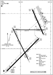
KCNM Airport Diagram
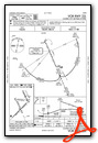
VFR Chart of KCNM
Sectional Charts at SkyVector.com
IFR Chart of KCNM
Enroute Charts at SkyVector.com
Location Information for KCNM
Coordinates: N32°20.25' / W104°15.80'Located 05 miles SW of Carlsbad, New Mexico on 1980 acres of land. View all Airports in New Mexico.
Surveyed Elevation is 3294 feet MSL.
Operations Data
|
|
Airport Communications
| ASOS: | 118.375 Tel. 575-887-6858 |
|---|---|
| UNICOM: | 123.000 |
| CTAF: | 123.000 |
| AWOS-3 at ATS (32.5 N): | 126.725 575-748-0270 |
| AWOS-3 at HOB (57.0 E): | 575-393-8418 |
| ATIS at HOB (57.0 E): | 119.75 |
- APCH/DEP SVC PRVDD BY ALBUQUERQUE ARTCC (ABQ) ON FREQS 135.875/292.15 (CARLSBAD RCAG).
Nearby Navigation Aids
|
| ||||||||||||||||||||||||||||||||||||||||||||||||


Runway 03/21
| Dimensions: | 7854 x 150 feet / 2394 x 46 meters | |
|---|---|---|
| Surface: | Asphalt / Porous Friction Course in Good Condition | |
| Weight Limits: | 20 /F/D/X/T, S-62, D-88, ST-140 | |
| Edge Lighting: | Medium Intensity | |
| Runway 03 | Runway 21 | |
| Coordinates: | N32°19.36' / W104°16.46' | N32°20.29' / W104°15.39' |
| Elevation: | 3294.5 | 3247.4 |
| Traffic Pattern: | Left | Left |
| Runway Heading: | 44° True | 224° True |
| Declared Distances: | TORA:7854 TODA:7854 ASDA:7504 LDA:7504 | TORA:7854 TODA:7854 ASDA:7854 LDA:7854 |
| Markings: | Precision Instrument in poor condition. | Non-Precision Instrument in poor condition. |
| Glide Slope Indicator | V4L (3.00° Glide Path Angle) | |
| Approach Lights: | MALSR 1,400 Foot Medium-intensity Approach Lighting System with runway alignment indicator lights. | |
| Obstacles: | 24 ft Road 1080 ft from runway, 623 ft left of center | 14 ft Road 388 ft from runway, 514 ft left of center |
Runway 14R/32L
| Dimensions: | 5837 x 100 feet / 1779 x 30 meters | |
|---|---|---|
| Surface: | Asphalt in Good Condition | |
| Weight Limits: | 9 /F/D/X/T, S-30, D-45 | |
| Edge Lighting: | Medium Intensity | |
| Runway 14R | Runway 32L | |
| Coordinates: | N32°20.57' / W104°16.25' | N32°19.71' / W104°15.76' |
| Elevation: | 3269.3 | 3266.8 |
| Traffic Pattern: | Right | Left |
| Runway Heading: | 154° True | 334° True |
| Displaced Threshold: | 385 Feet | |
| Declared Distances: | TORA:5837 TODA:5837 ASDA:5837 LDA:5837 | TORA:5837 TODA:5837 ASDA:5837 LDA:5452 |
| Markings: | Non-Precision Instrument in good condition. | Non-Precision Instrument in good condition. |
| Glide Slope Indicator | P4L (3.00° Glide Path Angle) | P4L (3.00° Glide Path Angle) |
| Obstacles: | 7 ft Road 300 ft from runway, 150 ft left of center | 15 ft Road 672 ft from runway, 318 ft right of center APCH SLOPE 50:1 FM DTHR. |
Runway 08/26
| Dimensions: | 5334 x 75 feet / 1626 x 23 meters | |
|---|---|---|
| Surface: | Asphalt in Good Condition | |
| Weight Limits: | 9 /F/C/Y/T, S-19 | |
| Edge Lighting: | Medium Intensity | |
| Runway 08 | Runway 26 | |
| Coordinates: | N32°20.54' / W104°16.24' | N32°20.54' / W104°15.21' |
| Elevation: | 3269.8 | 3238.8 |
| Traffic Pattern: | Left | Left |
| Runway Heading: | 90° True | 270° True |
| Declared Distances: | TORA:5334 TODA:5334 ASDA:5334 LDA:5334 | TORA:5334 TODA:5334 ASDA:5334 LDA:5334 |
| Markings: | Basic in good condition. | Basic in good condition. |
| Obstacles: | 15 ft Road 310 ft from runway | 4 ft Fence 200 ft from runway, 125 ft right of center |
Runway 14L/32R
ACR OPS NA. | ||
| Dimensions: | 4616 x 150 feet / 1407 x 46 meters | |
|---|---|---|
| Surface: | Asphalt in Fair Condition | |
| Weight Limits: | 4 /F/D/Y/T, S-8, D-12 | |
| Runway 14L | Runway 32R | |
| Coordinates: | N32°21.11' / W104°15.60' | N32°20.41' / W104°15.24' |
| Elevation: | 3240.6 | 3241.3 |
| Traffic Pattern: | Left | Right |
| Runway Heading: | 156° True | 336° True |
| Displaced Threshold: | 615 Feet | |
| Declared Distances: | TORA:4615 TODA:4615 ASDA:4615 LDA:4615 | TORA:4615 TODA:4615 ASDA:4615 LDA:3999 |
| Markings: | Basic in good condition. | Basic in good condition. |
| Obstacles: | 15 ft Road 230 ft from runway, 150 ft right of center APCH SLOPE 38:1 FM DTHR. |
|
Services Available
| Fuel: | 100LL (blue), Jet A-1+ |
|---|---|
| Transient Storage: | Hangars,Tiedowns |
| Airframe Repair: | NOT AVAILABLE |
| Engine Repair: | NOT AVAILABLE |
| Bottled Oxygen: | NOT AVAILABLE |
| Bulk Oxygen: | NOT AVAILABLE |
| Other Services: | AIR FREIGHT SERVICES,AIR AMBULANCE SERVICES |
Ownership Information
| Ownership: | Publicly owned | |
|---|---|---|
| Owner: | CITY OF CARLSBAD | |
| 101 NORTH HALAGUENO ST | ||
| CARLSBAD, NM 88220 | ||
| 575-887-1191 | ||
| Manager: | CARI PICKENS | |
| 101 NORTH HALAGUENO ST | ||
| CARLSBAD, NM 88220 | ||
| 575-887-3060 | ||
Operational Statistics
| Single Engine Aircraft Based on Field: | 21 | Statistics collected for 12 month period ending 2019-12-31 | |
|---|---|---|---|
| Multi-Engine Aircraft Based on Field: | 5 | Annual Commercial Operations: | 5224 |
| Jet Aircraft Based on Field: | 1 | Annual Commuter Operations: | none |
| Helicopters Based on Field: | 2 | Annual Air Taxi Operations: | none |
| Military Aircraft Based on Field: | none | Annual Military Operations: | 250 |
| Gliders Based on Field: | none | Annual GA Local Operations: | 3175 |
| Ultralights Based on Field: | none | Annual GA Itinerant Operations: | none |
Other Remarks
- OIL DERRICKS INVOF ARPT.
- FOR CD IF UNA TO CTC ON FSS FREQ, CTC ALBUQUERQUE ARTCC AT 505-856-4561.
- 0LL FUEL AFT HR & WKEND - 575-887-1500.
- ACTVT MALSR RWY 03; MIRL RWY 03/21, 08/26 & 14R/32L - CTAF. MALSR RWY 03 & MIRL RWY 03/21, 08/26, 14R/32L PRESET LOW INTST; INCR INTST - CTAF.
Weather Minimums
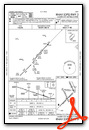
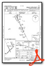
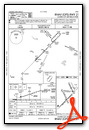
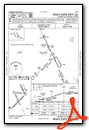
Instrument Approach Procedure (IAP) Charts
Nearby Airports with Instrument Procedures
| ID | Name | Heading / Distance | ||
|---|---|---|---|---|
 |
KATS | Artesia Municipal Airport | 341° | 32.5 |
|
E06 | Lea County/Zip Franklin Memorial Airport | 049° | 56.9 |
|
KHOB | Lea County Regional Airport | 068° | 57.1 |
|
KROW | Roswell Air Center Airport | 346° | 59.2 |
|
KINK | Winkler County Airport | 121° | 63.6 |
|
KPEQ | Pecos Municipal Airport | 145° | 68.9 |
|
KVHN | Culberson County Airport | 199° | 81.1 |
|
E01 | Roy Hurd Memorial Airport | 122° | 82.6 |
|
KGNC | Gaines County Airport | 075° | 84.2 |
|
E11 | Andrews County Airport | 089° | 88.1 |
|
F98 | Yoakum County Airport | 053° | 89.6 |
|
KALM | Alamogordo-White Sands Regional Airport | 289° | 92.6 |
Airport Images

By: Reble9mm


