Login
Register


CNO
Chino Airport
Official FAA Data Effective 2024-04-18 0901Z
Chart Supplement

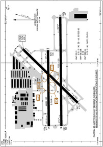
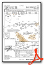
KCNO Airport Diagram
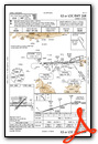
VFR Chart of KCNO
Sectional Charts at SkyVector.com
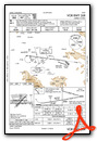
IFR Chart of KCNO
Enroute Charts at SkyVector.com
Location Information for KCNO
Coordinates: N33°58.49' / W117°38.19'Located 03 miles SE of Chino, California on 1097 acres of land. View all Airports in California.
Surveyed Elevation is 650 feet MSL.
TWIN ENGINE TPA 1350 FT AGL.
Operations Data
|
|
Airport Communications
| ATIS: | 125.85 ((909) 393-5365) |
|---|---|
| ASOS: | Tel. 909-393-5823 |
| CHINO TOWER: | 118.5 |
| CHINO GROUND: | 121.6 |
| SOCAL APPROACH: | 135.4 377.125 377.125 379.25 ;NE-EAST |
| SOCAL DEPARTURE: | 135.4 377.125 377.125 379.25 ;NE-EAST |
| IC: | 135.4 377.125 |
| SETER STAR: | 127.0 318.2 |
| CTAF: | 118.500 |
| CLASS C: | 135.4 ;SOUTH-SW 318.2 ;NORTH-NE 377.125 ;SOUTH-SW 379.25 ;NE-EAST |
| ZIGGY STAR: | 127.0 318.2 |
| UNICOM: | 122.950 |
| AWOS-3PT at AJO (5.2 S): | 132.175 951-340-4764 |
| ASOS at ONT (5.2 N): | 909-937-2186 |
| D-ATIS at ONT (5.2 N): | 124.25 |
Nearby Navigation Aids
|
| ||||||||||||||||||||||||||||||||||||||||||


Runway 08R/26L
| Dimensions: | 7000 x 150 feet / 2134 x 46 meters | |
|---|---|---|
| Surface: | Asphalt / Grooved in Good Condition | |
| Weight Limits: | S-75, D-150, ST-215 | |
| Edge Lighting: | Medium Intensity | |
| Runway 08R | Runway 26L | |
| Coordinates: | N33°58.41' / W117°38.80' | N33°58.42' / W117°37.42' |
| Elevation: | 619.5 | 636.5 |
| Traffic Pattern: | Right | |
| Runway Heading: | 89° True | 269° True |
| Markings: | Non-Precision Instrument in good condition. | Non-Precision Instrument in good condition. |
| Glide Slope Indicator | P4L (3.00° Glide Path Angle) | P4L (3.00° Glide Path Angle) |
| Obstacles: | 55 ft Trees 1320 ft from runway, 75 ft left of center | |
Runway 03/21
| Dimensions: | 4919 x 150 feet / 1499 x 46 meters | |
|---|---|---|
| Surface: | Asphalt in Good Condition | |
| Weight Limits: | S-21, D-130, DT-50 | |
| Edge Lighting: | Medium Intensity | |
| Runway 03 | Runway 21 | |
| Coordinates: | N33°58.24' / W117°38.51' | N33°58.82' / W117°37.83' |
| Elevation: | 610.4 | 649.7 |
| Traffic Pattern: | Right | Left |
| Runway Heading: | 44° True | 224° True |
| Markings: | Non-Precision Instrument in good condition. | Non-Precision Instrument in good condition. |
| Glide Slope Indicator | P4L (3.00° Glide Path Angle) | P4L (3.00° Glide Path Angle) |
| REIL: | Yes | Yes |
Runway 08L/26R
| Dimensions: | 4858 x 150 feet / 1481 x 46 meters | |
|---|---|---|
| Surface: | Asphalt in Good Condition | |
| Weight Limits: | S-12 | |
| Edge Lighting: | High Intensity | |
| Runway 08L | Runway 26R | |
| Coordinates: | N33°58.54' / W117°38.81' | N33°58.55' / W117°37.84' |
| Elevation: | 617.2 | 636.1 |
| Traffic Pattern: | Right | Left |
| Runway Heading: | 89° True | 269° True |
| Markings: | Basic in good condition. | Precision Instrument in good condition. |
| Glide Slope Indicator | P4L (3.00° Glide Path Angle) | P4L (3.00° Glide Path Angle) |
| Obstacles: | 65 ft Trees 1571 ft from runway, 140 ft left of center | 60 ft Trees 2150 ft from runway, 250 ft left of center |
Services Available
| Fuel: | 100LL (blue), Jet-A |
|---|---|
| Transient Storage: | Hangars,Tiedowns |
| Airframe Repair: | MAJOR |
| Engine Repair: | MAJOR |
| Bottled Oxygen: | NONE |
| Bulk Oxygen: | LOW |
| Other Services: | AIR FREIGHT SERVICES,AIR AMBULANCE SERVICES,AVIONICS,CARGO HANDLING SERVICES,CHARTER SERVICE,PILOT INSTRUCTION,AIRCRAFT RENTAL,AIRCRAFT SALES,GLIDER TOWING SERVICES |
Ownership Information
| Ownership: | Publicly owned | |
|---|---|---|
| Owner: | COUNTY OF SAN BERNARDINO | |
| 7000 MERRILL AVENUE BOX 1 | ||
| CHINO, CA 91710-9091 | ||
| 909-597-3910 | ||
| Manager: | MAUREEN SNELGROVE | AIRPORT OPERATIONS MANAGER |
| 777 EAST RIALTO AVE. | ||
| SAN BERNARDINO, CA 92415-0831 | ||
| 909-387-8810 | ||
Operational Statistics
| Single Engine Aircraft Based on Field: | 495 | Statistics collected for 12 month period ending 2016-09-30 | |
|---|---|---|---|
| Multi-Engine Aircraft Based on Field: | 96 | Annual Commercial Operations: | none |
| Jet Aircraft Based on Field: | 67 | Annual Commuter Operations: | none |
| Helicopters Based on Field: | 25 | Annual Air Taxi Operations: | 307 |
| Military Aircraft Based on Field: | none | Annual Military Operations: | none |
| Gliders Based on Field: | none | Annual GA Local Operations: | 102640 |
| Ultralights Based on Field: | none | Annual GA Itinerant Operations: | 61641 |
Other Remarks
- RADIO CONTROLLED AIRCRAFT ACTIVITY BELOW 400 FT AGL 2.5 NM SOUTH OF AIRPORT
- BIRDS AND WILDLIFE ON AND INVOF ARPT.
- FOR CD WHEN ATCT CLSD CTC SOCAL APCH AT 800-448-3724.
- 0LL SELF-SERVICE FUEL AVBL 24 HRS.
- WHEN ATCT CLSD MIRL RY 03/21, HIRL RY 08L/26R, MIRL 08R/26L ARE TURNED ON. PAPI RYS 26R, 08R, 26L, 03, 21 AND REIL RYS 03 & 21 OPER CONTINUOUSLY.
- TWIN ENGINE TPA 1350 FT AGL.
Weather Minimums
Standard Terminal Arrival (STAR) Charts

Instrument Approach Procedure (IAP) Charts
Nearby Airports with Instrument Procedures
| ID | Name | Heading / Distance | ||
|---|---|---|---|---|
 |
KAJO | Corona Municipal Airport | 159° | 4.9 |
|
KONT | Ontario International Airport | 019° | 5.2 |
|
KCCB | Cable Airport | 342° | 8.6 |
|
KRAL | Riverside Municipal Airport | 098° | 9.6 |
|
KPOC | Brackett Field Airport | 314° | 10.1 |
|
KRIR | Flabob Airport | 085° | 11.3 |
|
KFUL | Fullerton Municipal Airport | 250° | 18.2 |
|
KRIV | March Arb Airport | 106° | 19.6 |
|
KEMT | San Gabriel Valley Airport | 288° | 21.0 |
|
KSBD | San Bernardino International Airport | 070° | 21.3 |
|
KSNA | John Wayne/Orange County Airport | 212° | 21.3 |
|
KSLI | Los Alamitos AAF Airport | 242° | 23.5 |
Fuel Providers

Airport Images
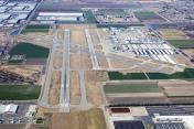
By: www.focalflight.com

By: Barnstormers Bi...
- 1 of 3
- next ›


