Login
Register


CQX
Chatham Municipal Airport
Official FAA Data Effective 2024-04-18 0901Z
Chart Supplement

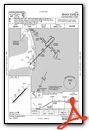
VFR Chart of KCQX
Sectional Charts at SkyVector.com
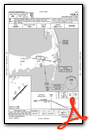
IFR Chart of KCQX
Enroute Charts at SkyVector.com
Location Information for KCQX
Coordinates: N41°41.30' / W69°59.38'Located 02 miles NW of Chatham, Massachusetts on 105 acres of land. View all Airports in Massachusetts.
Surveyed Elevation is 63 feet MSL.
Operations Data
|
|
Airport Communications
| ASOS: | 135.875 Tel. 508-945-5034 |
|---|---|
| BOSTON APPROACH: | 118.2 |
| BOSTON DEPARTURE: | 118.2 |
| CLEARANCE DELIVERY: | 127.3 |
| CTAF: | 122.800 |
| UNICOM: | 122.800 |
| ASOS at HYA (12.6 W): | 508-862-2601 |
| ATIS at HYA (13.1 W): | 123.8 |
| ASOS at FMH (23.9 W): | 508-968-6563 |
- APCH/DEP SVC PRVDD BY BOSTON ARTCC ON FREQS 128.75/290.3 (BARNSTABLE RCAG) 0000-0500.
Nearby Navigation Aids
|
| ||||||||||||||||||||||||||||||||||||||||||||||||||||||


Runway 06/24
| Dimensions: | 3001 x 100 feet / 915 x 30 meters | |
|---|---|---|
| Surface: | Asphalt in Good Condition | |
| Weight Limits: | S-30 | |
| Edge Lighting: | Medium Intensity | |
| Runway 06 | Runway 24 | |
| Coordinates: | N41°41.12' / W69°59.61' | N41°41.48' / W69°59.15' |
| Elevation: | 49.0 | 62.6 |
| Traffic Pattern: | Left | Left |
| Runway Heading: | 44° True | 224° True |
| Markings: | Basic in good condition. | Basic in good condition. |
| Glide Slope Indicator | P2L (3.50° Glide Path Angle) | P2R (3.50° Glide Path Angle) |
| REIL: | Yes | Yes |
| Obstacles: | 120 ft Trees 800 ft from runway, 150 ft right of center | 232 ft Tank 3100 ft from runway, 25 ft left of center |
Services Available
| Fuel: | 100LL (blue), Jet-A, Jet A+ |
|---|---|
| Transient Storage: | Hangars,Tiedowns |
| Airframe Repair: | MAJOR |
| Engine Repair: | MINOR |
| Bottled Oxygen: | NONE |
| Bulk Oxygen: | NONE |
| Other Services: | PILOT INSTRUCTION,AIRCRAFT RENTAL |
Ownership Information
| Ownership: | Publicly owned | |
|---|---|---|
| Owner: | TOWN OF CHATHAM | |
| 549 MAIN STREET | ||
| CHATHAM, MA 02633 | ||
| 508-945-5100 | ||
| Manager: | TIMOTHY HOWARD | |
| CHATHAM MUNICIPAL AIRPORT, GEORGE RYDER ROAD | ||
| CHATHAM, MA 02633 | ||
| 508-945-9000 | ||
Operational Statistics
| Single Engine Aircraft Based on Field: | 32 | Statistics collected for 12 month period ending 2023-06-01 | |
|---|---|---|---|
| Multi-Engine Aircraft Based on Field: | 2 | Annual Commercial Operations: | none |
| Jet Aircraft Based on Field: | none | Annual Commuter Operations: | none |
| Helicopters Based on Field: | 5 | Annual Air Taxi Operations: | 700 |
| Military Aircraft Based on Field: | none | Annual Military Operations: | 100 |
| Gliders Based on Field: | none | Annual GA Local Operations: | 14000 |
| Ultralights Based on Field: | none | Annual GA Itinerant Operations: | 7300 |
Other Remarks
- BE AWARE OF HIGH-SPD MIL JET & HVY HEL TFC VCNTY CAPE COD CGAS.
- BIRDS PRIMLY GULLS AND WILDLIFE ON OR INVOF ARPT.
- RCMD MIN ALT OF 2000 FT AGL FM NORTHEAST TO SOUTHEAST OF ARPT OVER NATL SEASHORE .
- WATER LDG AREA CLSD PERMLY.
- NOISE ABATEMENT RWY 6/24. USE FULL RWY & AVOID INTXN DEPS. MINIMIZE /AVOID TGL OPNS. CLIMB OUT ON RWY HDG TIL 1000 FT OVR WATER THEN PROCD ON CRS. REDUCE PWR AS SOON AS PRACTICAL.
- RWY 6/24, FLY PAT DOWNWIND LEG 1/2 TO 1 MILE OUT FM RWY AS PRACTICABLE.
- AVOID RESIDENTIAL AREAS AS MUCH AS PSBL.
- FOR CD CTC BOSTON APCH AT 603-594-5554.
- ACTVT MIRL RWY 06/24 - 122.95.
Weather Minimums
Instrument Approach Procedure (IAP) Charts
Nearby Airports with Instrument Procedures
| ID | Name | Heading / Distance | ||
|---|---|---|---|---|
 |
KHYA | Cape Cod Gateway Airport | 265° | 13.1 |
|
KFMH | Cape Cod Coast Guard Air Station Airport | 266° | 24.0 |
|
KPVC | Provincetown Municipal Airport | 335° | 25.2 |
|
5B6 | Falmouth Airpark Airport | 256° | 25.5 |
|
KACK | Nantucket Memorial Airport | 187° | 26.3 |
|
KMVY | Martha's Vineyard Airport | 238° | 33.2 |
|
KPYM | Plymouth Municipal Airport | 292° | 35.7 |
|
KGHG | Marshfield Municipal - George Harlow Field Airport | 308° | 39.2 |
|
KEWB | New Bedford Regional Airport | 269° | 43.5 |
|
KTAN | Taunton Municipal - King Field Airport | 283° | 47.4 |
|
1B9 | Mansfield Municipal Airport | 289° | 57.3 |
|
KUUU | Newport State Airport | 261° | 58.9 |
Airport Images
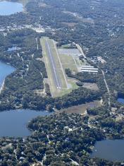
By: jfreesemd


