Login
Register


CRG
Jacksonville Exec At Craig Airport
Official FAA Data Effective 2024-04-18 0901Z
Chart Supplement

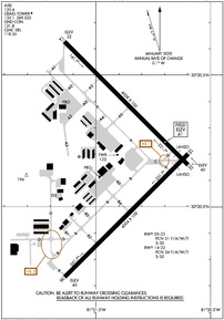
KCRG Airport Diagram
VFR Chart of KCRG
Sectional Charts at SkyVector.com
IFR Chart of KCRG
Enroute Charts at SkyVector.com
Location Information for KCRG
Coordinates: N30°20.18' / W81°30.87'Located 08 miles E of Jacksonville, Florida on 1432 acres of land. View all Airports in Florida.
Surveyed Elevation is 40 feet MSL.
Operations Data
|
|
Airport Communications
| ATIS: | 125.4 |
|---|---|
| ASOS: | 125.4 Tel. 904-646-4670 |
| CRAIG TOWER: | 132.1 269.525 |
| CRAIG GROUND: | 121.8 |
| JACKSONVILLE APPROACH: | 124.9 308.4 |
| JACKSONVILLE DEPARTURE: | 124.9 132.775 ;251-069 284.6 ;251-069 308.4 ;070-250 |
| CLEARANCE DELIVERY: | 118.35 |
| UNICOM: | 122.950 |
| ALCRN STAR: | 127.0 269.9 |
| CTAF: | 132.100 |
| ATIS at NRB (5.7 NE): | 236.775 |
| AWOS-3 at NIP (10.3 SW): | 119.275 |
| ATIS at NIP (10.4 SW): | 290.425 |
Nearby Navigation Aids
|
| ||||||||||||||||||||||||||||||||||||||||||||||||||||||||||||


Runway 14/32
| Dimensions: | 4008 x 100 feet / 1222 x 30 meters RY 14/32 HAS 75 FT STWYS BOTH ENDS. | |
|---|---|---|
| Surface: | Asphalt in Good Condition | |
| Weight Limits: | 34 /F/A/W/T, S-30 | |
| Edge Lighting: | High Intensity | |
| Runway 14 | Runway 32 | |
| Coordinates: | N30°20.63' / W81°31.14' | N30°20.16' / W81°30.60' |
| Elevation: | 32.0 | 40.3 |
| Traffic Pattern: | Left | Left |
| Runway Heading: | 135° True | 315° True |
| Markings: | Non-Precision Instrument in fair condition. | Precision Instrument in fair condition. |
| Glide Slope Indicator | P4L (3.00° Glide Path Angle) | P4L (3.00° Glide Path Angle) |
| Approach Lights: | MALSR 1,400 Foot Medium-intensity Approach Lighting System with runway alignment indicator lights. | |
| REIL: | Yes | |
| Obstacles: | 61 ft Trees 2465 ft from runway, 290 ft left of center | 20 ft Brush 1200 ft from runway, 220 ft right of center |
Runway 05/23
| Dimensions: | 4004 x 100 feet / 1220 x 30 meters RY 05/23 HAS 75 FT STWYS BOTH ENDS. | |
|---|---|---|
| Surface: | Asphalt in Fair Condition | |
| Weight Limits: | 31 /F/A/W/T, S-30 | |
| Edge Lighting: | Medium Intensity | |
| Runway 05 | Runway 23 | |
| Coordinates: | N30°19.73' / W81°31.14' | N30°20.20' / W81°30.60' |
| Elevation: | 40.1 | 40.3 |
| Traffic Pattern: | Left | Left |
| Runway Heading: | 45° True | 225° True |
| Markings: | Non-Precision Instrument in good condition. | Non-Precision Instrument in good condition. |
| Glide Slope Indicator | P4L (3.00° Glide Path Angle) UNUSBL BYD 3.5 MILES ON FINAL DUE TO LRG TWRS LCTD ON EXTDD CNTRLN. | P4L (3.00° Glide Path Angle) UNUSBL BYD 8.0 DEGS LEFT AND RIGHT OF CNTRLN. |
| REIL: | Yes | |
| Obstacles: | 114 ft Tower 3030 ft from runway, 250 ft right of center | 36 ft Trees 975 ft from runway, 240 ft left of center |
Services Available
| Fuel: | 100LL (blue), Jet-A |
|---|---|
| Transient Storage: | Hangars,Tiedowns |
| Airframe Repair: | MAJOR |
| Engine Repair: | MAJOR |
| Bottled Oxygen: | NONE |
| Bulk Oxygen: | NOT AVAILABLE |
| Other Services: | AIR AMBULANCE SERVICES,AVIONICS,CHARTER SERVICE,PILOT INSTRUCTION,AIRCRAFT RENTAL,AIRCRAFT SALES,ANNUAL SURVEYING |
Ownership Information
| Ownership: | Publicly owned | |
|---|---|---|
| Owner: | JACKSONVILLE AVIATION AUTHORITY | |
| 14201 PECAN PARK ROAD | ||
| JACKSONVILLE, FL 32218 | ||
| 904-573-1613 | ||
| Manager: | ROLF RIECHMANN | |
| 855-1 SAINT JOHNS BLUFF RD NORTH, SUITE 500 | ||
| JACKSONVILLE, FL 32225-8388 | ||
| 904-741-5066 | NOISE ABATEMENT COMPLAINTS 904-641-3606. | |
Operational Statistics
| Single Engine Aircraft Based on Field: | 175 | Statistics collected for 12 month period ending 2018-02-07 | |
|---|---|---|---|
| Multi-Engine Aircraft Based on Field: | 41 | Annual Commercial Operations: | none |
| Jet Aircraft Based on Field: | 12 | Annual Commuter Operations: | none |
| Helicopters Based on Field: | 8 | Annual Air Taxi Operations: | 7601 |
| Military Aircraft Based on Field: | 18 | Annual Military Operations: | 15039 |
| Gliders Based on Field: | none | Annual GA Local Operations: | 56209 |
| Ultralights Based on Field: | none | Annual GA Itinerant Operations: | 79920 |
Other Remarks
- BIRDS PERIODICALLY ON OR NEAR THE ARPT INCREASING IN ACTIVITY DURING INCLEMENT WEATHER.
- BANNER TOWING ON WEEKENDS & SPECIAL EVENTS.
- VFR NOISE ABATEMENT PROCEDURES IN EFFECT, CALL AMGR 904-641-7666. WX PERMITTING, RY 05 PREFERRED FOR APCH, RY 32 PREFERRED FOR DEP.
- WILDLIFE ON & INVOF ARPT.
- PAVEMENT ACCOMMODATES DESIGN GROUP II ACFT (UP TO 79 FT WINGSPAN) UP TO 60,000 LBS DUAL WHEEL LOADING. PPR FOR ACFT EXCEEDING THESE LTDS CTC AT 904-741-2020.
- WHEN ATCT CLSD ACTVT MALSR RWY 32; REIL RWY 14 & 23; HIRL RWY 14/32, MIRL RWY 5/23 - CTAF.
Weather Minimums


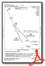
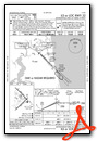
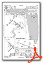
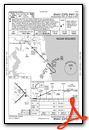
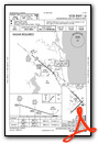
Standard Terminal Arrival (STAR) Charts
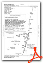
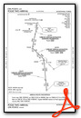
Instrument Approach Procedure (IAP) Charts
Nearby Airports with Instrument Procedures
| ID | Name | Heading / Distance | ||
|---|---|---|---|---|
 |
KNRB | Mayport Ns (Adm David L Mcdonald Field) Airport | 054° | 5.7 |
|
KNIP | Jacksonville NAS (Towers Field) Airport | 233° | 10.4 |
|
KJAX | Jacksonville International Airport | 316° | 13.0 |
|
KHEG | Herlong Recreational Airport | 257° | 15.5 |
|
KFHB | Fernandina Beach Municipal Airport | 009° | 16.7 |
|
KVQQ | Cecil Airport | 249° | 20.1 |
|
KSGJ | Northeast Florida Regional Airport | 158° | 24.3 |
|
42J | Keystone Heights Airport | 223° | 40.4 |
|
28J | Palatka Municipal - Lt Kay Larkin Field Airport | 192° | 41.6 |
|
09J | Jekyll Island Airport | 005° | 44.4 |
|
KSSI | St Simons Island Airport | 007° | 49.2 |
|
KFIN | Flagler Exec Airport | 162° | 54.5 |
Fuel Providers

Airport Images

By: n81693@yahoo.com


