Login
Register


CSM
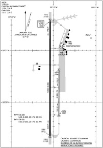
Clinton/Sherman Airport
Official FAA Data Effective 2024-03-21 0901Z
Chart Supplement

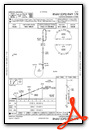
KCSM Airport Diagram
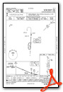
VFR Chart of KCSM
Sectional Charts at SkyVector.com
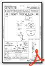
IFR Chart of KCSM
Enroute Charts at SkyVector.com
Location Information for KCSM
Coordinates: N35°20.39' / W99°12.03'Located 02 miles SW of Burns Flat, Oklahoma on 1690 acres of land. View all Airports in Oklahoma.
Surveyed Elevation is 1922 feet MSL.
Operations Data
|
|
Airport Communications
| ASOS: | 118.450 Tel. 580-562-4811 |
|---|---|
| CLINTON-SHERMAN TOWER: | 119.6 256.9 |
| CLINTON-SHERMAN GROUND: | 121.7 239.0 |
| UNICOM: | 122.950 |
| CTAF: | 119.600 |
| EMERG: | 121.5 243.0 |
| AWOS-3 at ELK (10.9 NW): | 118.225 580-303-9147 |
| AWOS-3 at CLK (17.7 NE): | 119.225 580-323-8477 |
| ASOS at HBR (22.2 S): | 133.325 580-726-6651 |
- APCH/DEP CTL SVC PRVDD BY FORT WORTH ARTCC (ZFW) ON FREQS 128.4/269.375 (CLINTON-SHERMAN RCAG).
Nearby Navigation Aids
|
| ||||||||||||||||||||||||||||||||||||||||||||||||


Runway 17R/35L
| Dimensions: | 13503 x 200 feet / 4116 x 61 meters | |
|---|---|---|
| Surface: | Concrete in Good Condition | |
| Weight Limits: | S-50, D-200, ST-390 | |
| Edge Lighting: | High Intensity NSTD; 75 FT FM RWY EDGE. | |
| Runway 17R | Runway 35L | |
| Coordinates: | N35°21.58' / W99°12.09' | N35°19.35' / W99°12.09' |
| Elevation: | 1922.1 | 1911.8 |
| Traffic Pattern: | Right | Left |
| Runway Heading: | 180° True | 0 |
| Markings: | Precision Instrument in good condition. | Precision Instrument in good condition. |
| Glide Slope Indicator | P4L (3.00° Glide Path Angle) | P4L (3.00° Glide Path Angle) |
| REIL: | Yes | Yes |
Runway 17L/35R
DALGT VFR ONLY. | ||
| Dimensions: | 5193 x 75 feet / 1583 x 23 meters | |
|---|---|---|
| Surface: | Concrete in Good Condition | |
| Weight Limits: | S-50, D-200, ST-390 | |
| Runway 17L | Runway 35R | |
| Coordinates: | N35°20.62' / W99°11.88' | N35°19.76' / W99°11.88' |
| Elevation: | 1906.2 | 1906.8 |
| Traffic Pattern: | Left | Right |
| Runway Heading: | 180° True | 0 |
| Markings: | Basic in good condition. | Basic in good condition. |
Services Available
| Fuel: | Jet-A |
|---|---|
| Transient Storage: | Hangars,Tiedowns |
| Airframe Repair: | MAJOR |
| Engine Repair: | MAJOR AEM AVBL FOR RPR ON SINGLE & MULTI ENG PISTON ACFT; NO TURBINE OR HEL RPR AVBL. |
| Bottled Oxygen: | HIGH |
| Bulk Oxygen: | NONE |
Ownership Information
| Ownership: | Publicly owned | |
|---|---|---|
| Owner: | OSIDA/STATE OF OKLAHOMA | |
| BOX 689 | ||
| BURNS FLAT, OK 73624 | ||
| 580-562-3500 | ||
| Manager: | CRAIG J. SMITH | |
| 121 1ST STREET | ||
| BURNS FLAT, OK 73624 | ||
| 580-309-3223 | ||
Operational Statistics
| Single Engine Aircraft Based on Field: | 11 | Statistics collected for 12 month period ending 2020-06-24 | |
|---|---|---|---|
| Multi-Engine Aircraft Based on Field: | none | Annual Commercial Operations: | none |
| Jet Aircraft Based on Field: | none | Annual Commuter Operations: | none |
| Helicopters Based on Field: | none | Annual Air Taxi Operations: | none |
| Military Aircraft Based on Field: | none | Annual Military Operations: | 32284 |
| Gliders Based on Field: | none | Annual GA Local Operations: | none |
| Ultralights Based on Field: | none | Annual GA Itinerant Operations: | 4453 |
Other Remarks
- THIS AIRPORT HAS BEEN SURVEYED BY THE NATIONAL GEODETIC SURVEY.
- MIL JET TRNG: HVY JETS SFC TO 5000 FT WI 25 NMR. EXTSV STUDENT PILOT TRNG FM SFC TO 5000 FT WI 10 NMR BTN 0900-1200.
- RWY 17L/35R LAID OUT & MRKD ON RWY 17L/35R PARL TWY.
- MIL JET NGT VISION TRNG: CTC ATCT 10 MINS PRIOR TO LDG AFT SS TO ADJUST ARPT LGTS.
- VFR ACFT ADZD TO CTC ATC 15 NM OUT FOR SEQG.
- 24 HR JET-A FUEL & OTR SVC AVBL - CTC 405-267-4010.
- LDG FEE FOR ACFT GTR THAN 50,000 LBS.
- ACTVT REIL RWY 17R & 35L; HIRL RWY 17R/35L; TWY LGT; WDI LGT - CTAF. PAPI RWY 17R & 35L ON CONSLY.
Weather Minimums
Instrument Approach Procedure (IAP) Charts
Nearby Airports with Instrument Procedures
| ID | Name | Heading / Distance | ||
|---|---|---|---|---|
 |
KELK | Elk City Regional Business Airport | 299° | 11.0 |
|
KCLK | Clinton Regional Airport | 047° | 17.7 |
|
KHBR | Hobart Regional Airport | 160° | 22.2 |
|
KOJA | Weatherford Stafford Airport | 064° | 28.9 |
|
2K4 | Scott Field Airport | 211° | 31.3 |
|
1O4 | Thomas Municipal Airport | 044° | 33.0 |
|
KAXS | Altus/Quartz Mountain Regional Airport | 190° | 39.0 |
|
KLTS | Altus AFB Airport | 184° | 40.4 |
|
2O8 | Hinton Municipal Airport | 076° | 43.2 |
|
T59 | Wheeler Municipal Airport | 278° | 49.5 |
|
KJWG | Watonga Regional Airport | 050° | 49.4 |
|
O35 | Hollis Municipal Airport | 222° | 51.6 |
Airport Images
Do you have a recent image of this airport? Upload it here!


