Login
Register


CVG
Cincinnati/Northern Kentucky International Airport
Official FAA Data Effective 2024-03-21 0901Z
Chart Supplement

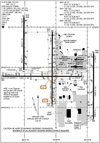
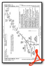
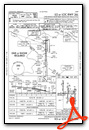
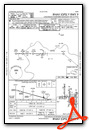
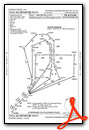
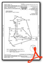
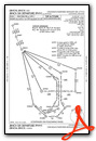
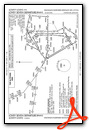
KCVG Airport Diagram
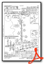
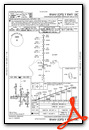
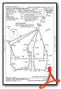
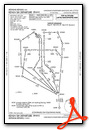
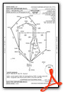
VFR Chart of KCVG
Sectional Charts at SkyVector.com
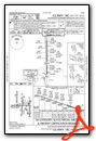
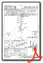
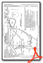
IFR Chart of KCVG
Enroute Charts at SkyVector.com
Location Information for KCVG
Coordinates: N39°2.93' / W84°40.07'Located 08 miles SW of Covington, Kentucky on 7000 acres of land. View all Airports in Kentucky.
Surveyed Elevation is 896 feet MSL.
Operations Data
|
|
Airport Communications
| D-ATIS: | 134.375 ;ARR 135.3 ;DEP |
|---|---|
| ASOS: | 134.375 Tel. 859-767-8210 |
| CINCINNATI TOWER: | 118.3 ;RWY 09/27, 18C/36C 118.975 ;RWY 18L/36R 133.325 ;RWY 18R/36L 360.85 ;RWY 18L/36R |
| CINCINNATI GROUND: | 121.7 |
| CINCINNATI APPROACH: | 119.7 ;090-269 123.875 ;270-089 363.15 |
| CINCINNATI DEPARTURE: | 126.65 ;001-180 128.7 ;181-360 254.25 |
| CLEARANCE DELIVERY: | 127.175 |
| CINCE STAR: | 123.875 254.25 |
| HARDU STAR: | 119.7 ;090-269 123.875 ;270-089 363.15 |
| SHELBYVILLE STAR: | 119.7 ;090-269 123.875 ;270-089 363.15 |
| UNICOM: | 122.950 |
| JAKIE STAR: | 119.7 254.25 |
| EMERG: | 121.5 243.0 |
| CLASS B: | 121.0 ;001-180 128.7 ;181-360 254.25 |
| ATIS at LUK (12.1 E): | 123.6 |
| ASOS at LUK (12.2 E): | 513-321-6291 |
| AWOS-3PT at I67 (13.4 N): | 118.15 513-569-4964 |
Nearby Navigation Aids
|
| ||||||||||||||||||||||||||||||||||||||||||||||||||||||||||||


Runway 09/27
W 4200 FT & E 750 FT CONC; REMAINDER ASPH OVERLAY. | ||
| Dimensions: | 12001 x 150 feet / 3658 x 46 meters | |
|---|---|---|
| Surface: | Asphalt-Concrete / Grooved in Good Condition | |
| Weight Limits: | 101/R/B/W/T, S-120, D-250, ST-550, DT-875 | |
| Edge Lighting: | High Intensity | |
| Runway 09 | Runway 27 | |
| Coordinates: | N39°2.78' / W84°41.71' | N39°2.78' / W84°39.17' |
| Elevation: | 883.3 | 875.0 |
| Traffic Pattern: | Left | Left |
| Runway Heading: | 90° True | 270° True |
| Declared Distances: | TORA:12000 TODA:12000 ASDA:11640 LDA:11640 | TORA:12000 TODA:12000 ASDA:12000 LDA:12000 |
| Markings: | Precision Instrument in good condition. | Precision Instrument in good condition. |
| Glide Slope Indicator | P4L (3.00° Glide Path Angle) | P4L (3.00° Glide Path Angle) |
| RVR Equipment | Touchdown Rollout | Touchdown Rollout |
| Approach Lights: | MALSR 1,400 Foot Medium-intensity Approach Lighting System with runway alignment indicator lights. | MALSR 1,400 Foot Medium-intensity Approach Lighting System with runway alignment indicator lights. |
| Centerline Lights: | Yes | Yes |
Runway 18C/36C
| Dimensions: | 11000 x 150 feet / 3353 x 46 meters | |
|---|---|---|
| Surface: | Asphalt-Concrete / Grooved in Good Condition | |
| Weight Limits: | 112/F/C/W/T, S-120, D-250, ST-550, DT-875 | |
| Edge Lighting: | High Intensity | |
| Runway 18C | Runway 36C | |
| Coordinates: | N39°3.88' / W84°40.12' | N39°2.07' / W84°40.12' |
| Elevation: | 874.6 | 840.7 |
| Traffic Pattern: | Left | Left |
| Runway Heading: | 180° True | 0 |
| Markings: | Precision Instrument in good condition. | Precision Instrument in good condition. |
| Glide Slope Indicator | P4R (3.00° Glide Path Angle) | P4L (3.00° Glide Path Angle) |
| RVR Equipment | Touchdown Midfield Rollout | Touchdown Midfield Rollout |
| Approach Lights: | MALSR 1,400 Foot Medium-intensity Approach Lighting System with runway alignment indicator lights. | ALSF2 Standard 2,400 Foot High-intensity Approach Lighting System with sequenced flashers, CATEGORY II or III Configuration. |
| Centerline Lights: | Yes | Yes |
Runway 18L/36R
| Dimensions: | 10000 x 150 feet / 3048 x 46 meters | |
|---|---|---|
| Surface: | Concrete / Grooved in Good Condition | |
| Weight Limits: | 127/R/B/W/T, S-120, D-250, ST-550, DT-875 | |
| Edge Lighting: | High Intensity | |
| Runway 18L | Runway 36R | |
| Coordinates: | N39°3.35' / W84°38.80' | N39°1.70' / W84°38.81' |
| Elevation: | 886.3 | 896.1 |
| Runway Heading: | 180° True | 0 |
| Markings: | Precision Instrument in good condition. | Precision Instrument in good condition. |
| Glide Slope Indicator | P4L (3.00° Glide Path Angle) | P4R (3.00° Glide Path Angle) |
| RVR Equipment | Touchdown Midfield Rollout | Touchdown Midfield Rollout |
| Approach Lights: | MALSR 1,400 Foot Medium-intensity Approach Lighting System with runway alignment indicator lights. | ALSF2 Standard 2,400 Foot High-intensity Approach Lighting System with sequenced flashers, CATEGORY II or III Configuration. |
| Centerline Lights: | Yes | Yes |
Runway 18R/36L
| Dimensions: | 8000 x 150 feet / 2438 x 46 meters | |
|---|---|---|
| Surface: | Concrete / Grooved in Good Condition | |
| Weight Limits: | 170/R/B/W/T, S-120, D-250, ST-550, DT-875 | |
| Edge Lighting: | High Intensity | |
| Runway 18R | Runway 36L | |
| Coordinates: | N39°4.25' / W84°41.02' | N39°2.94' / W84°41.03' |
| Elevation: | 864.7 | 872.6 |
| Runway Heading: | 180° True | 0 |
| Markings: | Precision Instrument in good condition. | Precision Instrument in good condition. |
| RVR Equipment | Touchdown Midfield Rollout | Touchdown Midfield Rollout |
| Approach Lights: | ALSF2 Standard 2,400 Foot High-intensity Approach Lighting System with sequenced flashers, CATEGORY II or III Configuration. | ALSF2 Standard 2,400 Foot High-intensity Approach Lighting System with sequenced flashers, CATEGORY II or III Configuration. |
| Centerline Lights: | Yes | Yes |
Services Available
| Fuel: | 100LL (blue), Jet-A |
|---|---|
| Transient Storage: | Hangars,Tiedowns |
| Airframe Repair: | MAJOR |
| Engine Repair: | MAJOR |
| Bottled Oxygen: | NOT AVAILABLE |
| Bulk Oxygen: | NOT AVAILABLE |
| Other Services: | AIR FREIGHT SERVICES,AVIONICS,CARGO HANDLING SERVICES,CHARTER SERVICE,PILOT INSTRUCTION,AIRCRAFT RENTAL |
Ownership Information
| Ownership: | Publicly owned | |
|---|---|---|
| Owner: | KENTON COUNTY ARPT BOARD | |
| PO BOX 752000 | ||
| CINCINNATI, OH 45275-2000 | ||
| 859-767-3151 | ||
| Manager: | CANDACE MCGRAW | |
| PO BOX 752000 | ||
| CINCINNATI, OH 45275-2000 | ||
| 859-767-3151 | ||
Operational Statistics
| Single Engine Aircraft Based on Field: | none | Statistics collected for 12 month period ending 2022-07-31 | |
|---|---|---|---|
| Multi-Engine Aircraft Based on Field: | 3 | Annual Commercial Operations: | 129174 |
| Jet Aircraft Based on Field: | 8 | Annual Commuter Operations: | none |
| Helicopters Based on Field: | none | Annual Air Taxi Operations: | 7592 |
| Military Aircraft Based on Field: | none | Annual Military Operations: | 133 |
| Gliders Based on Field: | none | Annual GA Local Operations: | 2389 |
| Ultralights Based on Field: | none | Annual GA Itinerant Operations: | 4590 |
Other Remarks
- SUCCESSIVE OR SIMUL DEP FM RWY 18L, 18C, 36L, 36C & 36R APVD WITH COURSE DVRG BGN NO FURTHER THAN 2 MI FM EOR DUE TO NOISE ABATEMENT.
- TWYS RSTRD TO 15 MPH OR LESS WITH WINGSPAN 214 FT OR MORE.
- BIRDS ON & INVOF THE ARPT.
- RAMP CTL: RAMP 1N / 1S TXL & RAMP 2N / 2S TXL - 130.90, RAMP 3 TXL & N TXL - 130.375; DHL RAMP CTL: 129.475; AMZ RAMP CTL: 130.5.
- OPR PARROT WITH ALT RPRTG MODE & ADS-B ENABLED ON ARPT SFCS.
- RWY 18R/36L CLSD TO AIR CARRIER ACFT WINGSPAN MORE THAN 140FT
- NOISE SENS AREA N & S OF ARPT; RWY ASGN 2200-0700 BASED ON NOISE ABATEMENT.
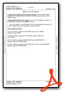
Weather Minimums
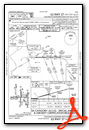
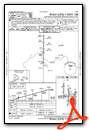
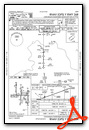
Standard Terminal Arrival (STAR) Charts
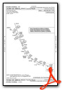
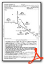


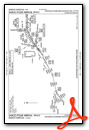
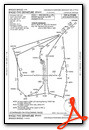
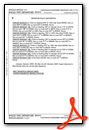
Instrument Approach Procedure (IAP) Charts
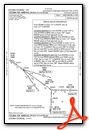
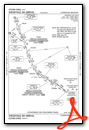
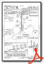
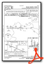
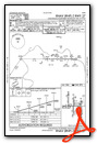
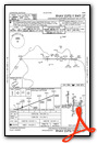
- ILS OR LOC RWY 09
- ILS OR LOC RWY 18C
- ILS OR LOC RWY 18L
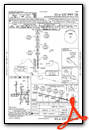
- ILS OR LOC RWY 18R
- ILS OR LOC RWY 27
- ILS OR LOC RWY 36C
- ILS OR LOC RWY 36L
- ILS OR LOC RWY 36R
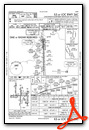
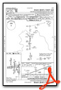
- ILS RWY 18C (SA CAT I - II)
- ILS RWY 27 (SA CAT I - II)
- ILS RWY 18R (CAT II)
- ILS RWY 36L (CAT II)
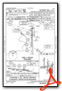
- ILS RWY 36C (CAT II - III)
- ILS RWY 36R (CAT II - III)
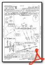
- RNAV (RNP) Z RWY 09
- RNAV (RNP) Z RWY 18C
- RNAV (RNP) Z RWY 18L
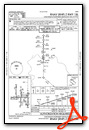
- RNAV (RNP) Z RWY 18R
- RNAV (RNP) Z RWY 27
- RNAV (RNP) Z RWY 36C
- RNAV (RNP) Z RWY 36L
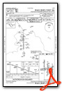
- RNAV (RNP) Z RWY 36R
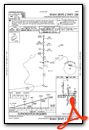
- RNAV (GPS) Y RWY 09
- RNAV (GPS) Y RWY 18C
- RNAV (GPS) Y RWY 18L
- RNAV (GPS) Y RWY 18R
- RNAV (GPS) Y RWY 27
- RNAV (GPS) Y RWY 36C
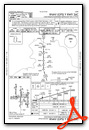
- RNAV (GPS) Y RWY 36L
- RNAV (GPS) Y RWY 36R
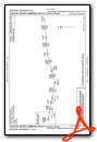
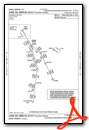
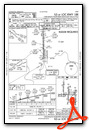
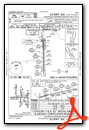
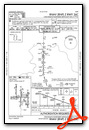
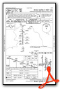
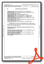
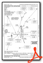
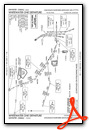
Departure Procedure (DP) Charts
- BLUEGRASS FOUR
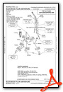
- BLUEGRASS FOUR, CONT.1
- BNGLE FIVE (RNAV)
- BNGLE FIVE (RNAV), CONT.1
- CHCLL SIX (RNAV)
- CHCLL SIX (RNAV), CONT.1
- CINCINNATI FIVE
- CINCINNATI FIVE, CONT.1
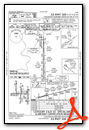
- GIPLE SEVEN (RNAV)
- GIPLE SEVEN (RNAV), CONT.1
- HAGOL FIVE (RNAV)
- HAGOL FIVE (RNAV), CONT.1
- JBNCH SIX (RNAV)
- JBNCH SIX (RNAV), CONT.1
- KENLN SIX (RNAV)
- KENLN SIX (RNAV), CONT.1
- LOVEY SEVEN (RNAV)
- LOVEY SEVEN (RNAV), CONT.1

- ROCKT TWO (RNAV)
- ROCKT TWO (RNAV), CONT.1
- SILKS FIVE (RNAV)
- SILKS FIVE (RNAV), CONT.1

- WHITEWATER ONE
- WHITEWATER ONE, CONT.1
Nearby Airports with Instrument Procedures
| ID | Name | Heading / Distance | ||
|---|---|---|---|---|
 |
KLUK | Cincinnati Municipal/Lunken Field Airport | 074° | 12.1 |
|
I67 | Cincinnati West Airport | 338° | 13.6 |
|
KHAO | Butler County Regional/Hogan Field Airport | 019° | 20.1 |
|
I69 | Clermont County Airport | 085° | 21.5 |
|
K62 | Gene Snyder Airport | 147° | 24.4 |
|
KOXD | Miami University Airport | 348° | 27.7 |
|
I68 | Warren County/John Lane Field Airport | 037° | 31.5 |
|
KMWO | Middletown Regional/Hook Field Airport | 023° | 31.6 |
|
KGEO | Brown County Airport | 104° | 38.1 |
|
KMGY | Dayton/Wright Brothers Airport | 032° | 38.4 |
|
KIMS | Madison Municipal Airport | 245° | 41.1 |
|
I73 | Moraine Air Park Airport | 027° | 42.9 |
Airport Images

By: japanjeff


