Login
Register


CYO
Pickaway County Memorial Airport
Official FAA Data Effective 2024-04-18 0901Z
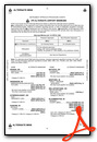
Chart Supplement

VFR Chart of KCYO
Sectional Charts at SkyVector.com
IFR Chart of KCYO
Enroute Charts at SkyVector.com
Location Information for KCYO
Coordinates: N39°30.96' / W82°58.93'Located 05 miles S of Circleville, Ohio on 61 acres of land. View all Airports in Ohio.
Surveyed Elevation is 684 feet MSL.
Operations Data
|
|
Airport Communications
| COLUMBUS APPROACH: | 132.3 ;100-279 134.0 279.6 |
|---|---|
| COLUMBUS DEPARTURE: | 132.3 ;100-279 134.0 279.6 |
| IC: | 134.0 279.6 |
| UNICOM: | 122.700 |
| CTAF: | 122.700 |
| CLASS C/S: | 132.3 ;100-279 |
| AWOS-3 at RZT (4.9 S): | 119.225 740-779-1364 |
| AWOS-3 at LCK (17.4 N): | 614-492-2441 |
| ATIS at LCK (18.1 N): | 132.75 |
Nearby Navigation Aids
|
| ||||||||||||||||||||||||||||||||||||||||||||||||||||||||||||


Runway 01/19
| Dimensions: | 4346 x 75 feet / 1325 x 23 meters | |
|---|---|---|
| Surface: | Asphalt in Good Condition | |
| Weight Limits: | S-30, D-40 | |
| Edge Lighting: | Medium Intensity | |
| Runway 01 | Runway 19 | |
| Coordinates: | N39°30.60' / W82°58.95' | N39°31.32' / W82°58.90' |
| Elevation: | 663.7 | 684.8 |
| Traffic Pattern: | Left | Left |
| Runway Heading: | 3° True | 183° True |
| Markings: | Non-Precision Instrument in good condition. | Non-Precision Instrument in good condition. |
| Glide Slope Indicator | P4R (3.00° Glide Path Angle) | |
| REIL: | Yes | |
| Obstacles: | 56 ft Trees 989 ft from runway, 316 ft right of center | |
Services Available
| Fuel: | 100LL (blue), Jet-A |
|---|---|
| Transient Storage: | Tiedowns |
| Airframe Repair: | NONE |
| Engine Repair: | NONE |
| Bottled Oxygen: | NONE |
| Bulk Oxygen: | NONE |
Ownership Information
| Ownership: | Publicly owned | |
|---|---|---|
| Owner: | PICKAWAY CO AIRPORT AUTHORITY | |
| 28181 MCCRADY RD | ||
| CIRCLEVILLE, OH 43113-9725 | ||
| 740-474-5145 | ||
| Manager: | PICKAWAY CO AIRPORT AUTHORITY | |
| 28181 MCCRADY RD | ||
| CIRCLEVILLE, OH 43113-9725 | ||
| 740-474-5145 | ||
Operational Statistics
| Single Engine Aircraft Based on Field: | 26 | Statistics collected for 12 month period ending 2021-07-21 | |
|---|---|---|---|
| Multi-Engine Aircraft Based on Field: | none | Annual Commercial Operations: | none |
| Jet Aircraft Based on Field: | none | Annual Commuter Operations: | none |
| Helicopters Based on Field: | none | Annual Air Taxi Operations: | none |
| Military Aircraft Based on Field: | none | Annual Military Operations: | 1500 |
| Gliders Based on Field: | none | Annual GA Local Operations: | 26250 |
| Ultralights Based on Field: | none | Annual GA Itinerant Operations: | 8200 |
Other Remarks
- FOR CD CTC COLUMBUS APCH AT 614-338-8537.
- 0LL 100LL & JET A AVBL H24 VIA CREDIT CARD.
- ACTVT REIL RWY 19; PAPI RWY 19; MIRL RWY 01/19 - CTAF.
Weather Minimums

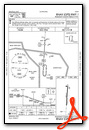
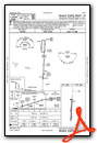
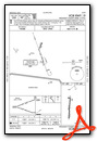
Instrument Approach Procedure (IAP) Charts
Nearby Airports with Instrument Procedures
| ID | Name | Heading / Distance | ||
|---|---|---|---|---|
 |
KRZT | Ross County Airport | 202° | 4.9 |
|
KLCK | Rickenbacker International Airport | 008° | 18.0 |
|
I23 | Fayette County Airport | 279° | 20.6 |
|
KLHQ | Fairfield County Airport | 046° | 20.8 |
|
KEOP | Pike County Airport | 173° | 21.1 |
|
KTZR | Bolton Field Airport | 342° | 24.2 |
|
KCMH | John Glenn Columbus International Airport | 008° | 29.1 |
|
KHOC | Highland County Airport | 233° | 32.5 |
|
KUYF | Madison County Airport | 318° | 33.4 |
|
KOSU | Ohio State University Airport | 352° | 34.0 |
|
KJRO | James A Rhodes Airport | 149° | 37.2 |
|
I86 | Perry County Airport | 073° | 37.9 |
Airport Images
Do you have a recent image of this airport? Upload it here!


