Login
Register


DCM
Chester Catawba Regional Airport
Official FAA Data Effective 2024-03-21 0901Z
Chart Supplement

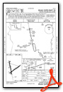
VFR Chart of KDCM
Sectional Charts at SkyVector.com
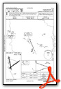
IFR Chart of KDCM
Enroute Charts at SkyVector.com
Location Information for KDCM
Coordinates: N34°47.36' / W81°11.75'Located 05 miles N of Chester, South Carolina on 1047 acres of land. View all Airports in South Carolina.
Surveyed Elevation is 656 feet MSL.
Operations Data
|
|
Airport Communications
| AWOS-3: | 120.975 Tel. 803-385-2011 |
|---|---|
| CHARLOTTE APPROACH: | 120.05 307.8 |
| CHARLOTTE DEPARTURE: | 120.05 307.8 |
| CTAF: | 122.700 |
| UNICOM: | 122.700 |
| RASLN STAR: | 126.15 282.325 |
| JOOLS STAR: | 135.6 377.15 |
| ASOS at UZA (13.7 NE): | 120.775 803-981-9388 |
| AWOS-3 at LKR (17.3 E): | 120.825 803-286-6444 |
| AWOS-3PT at 35A (22.9 W): | 119.45 864-427-1514 |
Nearby Navigation Aids
|
| ||||||||||||||||||||||||||||||||||||||||||||||||||||||||||||


Runway 17/35
| Dimensions: | 5000 x 100 feet / 1524 x 30 meters | |
|---|---|---|
| Surface: | Asphalt in Fair Condition | |
| Weight Limits: | S-30, D-44 | |
| Edge Lighting: | Medium Intensity | |
| Runway 17 | Runway 35 | |
| Coordinates: | N34°47.82' / W81°12.02' | N34°47.01' / W81°11.82' |
| Elevation: | 656.6 | 636.1 |
| Traffic Pattern: | Right | Left |
| Runway Heading: | 168° True | 348° True |
| Markings: | Non-Precision Instrument in fair condition. | Non-Precision Instrument in fair condition. |
| Glide Slope Indicator | P2L (3.00° Glide Path Angle) | P2L (3.00° Glide Path Angle) |
| Obstacles: | 36 ft Tree 779 ft from runway, 140 ft right of center | 38 ft Tree 1426 ft from runway, 180 ft left of center |
Runway 05/23
| Dimensions: | 4998 x 100 feet / 1523 x 30 meters | |
|---|---|---|
| Surface: | Asphalt in Poor Condition RWY 05/23 PCI RATING 40 VERY POOR. | |
| Weight Limits: | S-4, D-12 | |
| Runway 05 | Runway 23 | |
| Coordinates: | N34°47.06' / W81°11.98' | N34°47.54' / W81°11.17' |
| Elevation: | 641.7 | 620.3 |
| Traffic Pattern: | Right | Left |
| Runway Heading: | 55° True | 235° True |
| Displaced Threshold: | 949 Feet | |
| Markings: | Basic in good condition. | Basic in good condition. |
| Obstacles: | 76 ft Tree 1433 ft from runway, 223 ft left of center | 22 ft Tree 310 ft from runway, 86 ft right of center |
Services Available
| Fuel: | 100LL (blue), Jet-A |
|---|---|
| Transient Storage: | Hangars,Tiedowns |
| Airframe Repair: | NONE |
| Engine Repair: | NONE |
| Bottled Oxygen: | NONE |
| Bulk Oxygen: | NONE |
| Other Services: | PARACHUTE JUMP ACTIVITY |
Ownership Information
| Ownership: | Publicly owned | |
|---|---|---|
| Owner: | COUNTY OF CHESTER | |
| P.O. BOX 594 | ||
| CHESTER, SC 29706 | ||
| (803) 385-3154 | ||
| Manager: | KEITH ROACH | ARPT CAN BE ACESD BY PEDESTRIAN GATE NEXT TO TRML BLDG AFT HRS BY FIRST FOUR NRS OF AWOS FREQ IN COMBINATION LOCK BOX. |
| 1854-A, PIPER DR. | ||
| CHESTER, SC 29706 | ||
| 803-385-6664 | ||
Operational Statistics
| Single Engine Aircraft Based on Field: | 27 | Statistics collected for 12 month period ending 2022-06-23 | |
|---|---|---|---|
| Multi-Engine Aircraft Based on Field: | 2 | Annual Commercial Operations: | none |
| Jet Aircraft Based on Field: | none | Annual Commuter Operations: | none |
| Helicopters Based on Field: | none | Annual Air Taxi Operations: | none |
| Military Aircraft Based on Field: | none | Annual Military Operations: | none |
| Gliders Based on Field: | none | Annual GA Local Operations: | 6000 |
| Ultralights Based on Field: | none | Annual GA Itinerant Operations: | 2400 |
Other Remarks
- FOR CD CTC CHARLOTTE APCH AT 704-359-0241.
- 0LL FOR FUEL OR ANY SVC AFT HRS CALL 803-385-6664.
- ACTVT PAPI RWY 17 & 35; MIRL RWY 17/35 - CTAF.
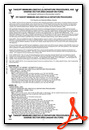
Weather Minimums
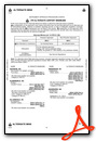
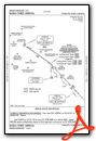
Standard Terminal Arrival (STAR) Charts
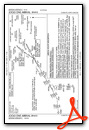
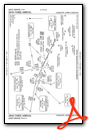
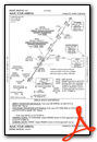
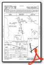
Instrument Approach Procedure (IAP) Charts
Nearby Airports with Instrument Procedures
| ID | Name | Heading / Distance | ||
|---|---|---|---|---|
 |
KUZA | Rock Hill/York County/Bryant Field Airport | 029° | 13.7 |
|
KLKR | Lancaster County-Mc Whirter Field Airport | 103° | 17.3 |
|
N52 | Jaars-Townsend Airport | 078° | 22.6 |
|
35A | Union County, Troy Shelton Field Airport | 254° | 22.9 |
|
KAKH | Gastonia Municipal Airport | 005° | 24.9 |
|
KCLT | Charlotte/Douglas International Airport | 025° | 28.2 |
|
KFDW | Fairfield County Airport | 171° | 28.7 |
|
KEQY | Charlotte/Monroe Exec Airport | 064° | 31.4 |
|
KEHO | Shelby-Cleveland County Regional Airport | 324° | 34.3 |
|
KEOE | Newberry County Airport | 217° | 36.2 |
|
KSPA | Spartanburg Downtown Memorial/Simpson Field Airport | 281° | 38.3 |
|
KLUX | Laurens County Airport | 245° | 40.8 |
Airport Images
Do you have a recent image of this airport? Upload it here!


