Login
Register


DHT
Dalhart Municipal Airport
Official FAA Data Effective 2024-04-18 0901Z
Chart Supplement

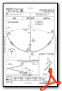
VFR Chart of KDHT
Sectional Charts at SkyVector.com
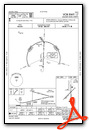
IFR Chart of KDHT
Enroute Charts at SkyVector.com
Location Information for KDHT
Coordinates: N36°1.35' / W102°32.84'Located 03 miles SW of Dalhart, Texas on 1206 acres of land. View all Airports in Texas.
Surveyed Elevation is 3991 feet MSL.
Operations Data
|
|
Airport Communications
| ASOS: | 134.075 Tel. 806-249-5671 |
|---|---|
| UNICOM: | 122.950 |
| CTAF: | 122.950 |
| AWOS-3 at DUX (27.9 E): | 118.075 806-934-3390 |
| ASOS at CAO (38.9 NW): | 120.625 575-374-2565 |
| ASOS at BGD (59.4 E): | 118.325 806-274-7318 |
- APCH/DEP SVC PRVDD BY ALBUQUERQUE ARTCC (ZAB) ON FREQS 127.85/285.475 (AMARILLO RCAG).
Nearby Navigation Aids
|
| ||||||||||||||||||||||||||||||||||||||||||||||||||||||||||||


Runway 17/35
| Dimensions: | 6400 x 75 feet / 1951 x 23 meters | |
|---|---|---|
| Surface: | Asphalt in Fair Condition | |
| Weight Limits: | S-20, D-30 | |
| Edge Lighting: | Medium Intensity | |
| Runway 17 | Runway 35 | |
| Coordinates: | N36°1.87' / W102°32.79' | N36°0.81' / W102°32.78' |
| Elevation: | 3991.0 | 3986.7 |
| Traffic Pattern: | Left | Left |
| Runway Heading: | 180° True | 360° True |
| Markings: | Non-Precision Instrument in fair condition. | Non-Precision Instrument in fair condition. |
| Glide Slope Indicator | P4L (3.00° Glide Path Angle) | P4L (3.00° Glide Path Angle) |
| REIL: | Yes | Yes |
Runway 03/21
| Dimensions: | 5440 x 75 feet / 1658 x 23 meters | |
|---|---|---|
| Surface: | Asphalt in Excellent Condition | |
| Weight Limits: | S-30 | |
| Edge Lighting: | Medium Intensity | |
| Runway 03 | Runway 21 | |
| Coordinates: | N36°1.04' / W102°33.30' | N36°1.68' / W102°32.52' |
| Elevation: | 3983.2 | 3982.3 |
| Traffic Pattern: | Left | Left |
| Runway Heading: | 45° True | 225° True |
| Markings: | Basic in fair condition. | Basic in fair condition. |
| Obstacles: | 18 ft Tree 740 ft from runway, 125 ft right of center | 7 ft Antenna 271 ft from runway, 227 ft right of center 16 FT TREE 91 FT FM THR, 141 FT LEFT. |
Services Available
| Fuel: | 100LL (blue), Jet A-1 |
|---|---|
| Transient Storage: | Hangars,Tiedowns |
| Airframe Repair: | MAJOR |
| Engine Repair: | MAJOR |
| Bottled Oxygen: | NONE |
| Bulk Oxygen: | NONE |
| Other Services: | CROP DUSTING SERVICES,PILOT INSTRUCTION |
Ownership Information
| Ownership: | Publicly owned | |
|---|---|---|
| Owner: | CITY OF DALHART | |
| PO BOX 2005 | ||
| DALHART, TX 79022 | ||
| 806-244-5511 | ||
| Manager: | STACEY NORRIS | CITY MGR. |
| PO BOX 2005 | ||
| DALHART, TX 79022 | ||
| 806-244-5511 | CELL 301-204-3302 | |
Operational Statistics
| Single Engine Aircraft Based on Field: | 36 | Statistics collected for 12 month period ending 2021-09-16 | |
|---|---|---|---|
| Multi-Engine Aircraft Based on Field: | 6 | Annual Commercial Operations: | none |
| Jet Aircraft Based on Field: | none | Annual Commuter Operations: | none |
| Helicopters Based on Field: | none | Annual Air Taxi Operations: | none |
| Military Aircraft Based on Field: | none | Annual Military Operations: | 150 |
| Gliders Based on Field: | 1 | Annual GA Local Operations: | 5000 |
| Ultralights Based on Field: | none | Annual GA Itinerant Operations: | 2500 |
Other Remarks
- LARGE FLOCKS OF WATERFOWL INVOF LAKE RITA BLANCA 2 MI EAST DURING FALL.
- FOR CD IF UNA TO CTC ON FSS FREQ, CTC ALBUQUERQUE ARTCC AT 505-856-4561.
- RAMP & TWYS PAVEMENT POOR COND. LOOSE ASPH, STONES, AGGREGATE ON SFC, POT HOLES & EXTSV CRACKING.
- 0LL FOR FUEL AFT HRS CALL 806-244-5521 DURG BUS HRS.
- MIRL RWYS 03/21 & 17/35 PRESET LOW INTST; TO INCR INTST & ACTVT PAPI RWYS 17 & 35 - CTAF.
Weather Minimums
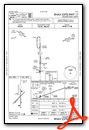
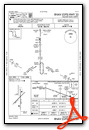
Instrument Approach Procedure (IAP) Charts
Nearby Airports with Instrument Procedures
| ID | Name | Heading / Distance | ||
|---|---|---|---|---|
 |
KDUX | Moore County Airport | 110° | 27.8 |
|
KCAO | Clayton Municipal Airpark Airport | 311° | 38.7 |
|
17K | Boise City Airport | 002° | 45.1 |
|
E19 | Gruver Municipal Airport | 076° | 55.7 |
|
KBGD | Hutchinson County Airport | 108° | 59.5 |
|
KTDW | Tradewind Airport | 145° | 62.1 |
|
KAMA | Rick Husband Amarillo International Airport | 139° | 63.3 |
|
KGUY | Guymon Municipal Airport | 051° | 64.1 |
|
E42 | Major Samuel B Cornelius Field Airport | 079° | 66.8 |
|
KEHA | Elkhart-Morton County Airport | 028° | 66.9 |
|
T45 | Panhandle-Carson County Airport | 124° | 70.0 |
|
KHRX | Hereford Municipal Airport | 171° | 70.4 |
Airport Images

By: brb

By: brb


Comments
Great Place to Stop
Nice runways. Excellent FBO (Larsen Aviation). Restaurant on field open 6-2 7-days a week. Competitive fuel prices. Great place for a break or stop over.