Login
Register


DKB
De Kalb Taylor Municipal Airport
Official FAA Data Effective 2024-04-18 0901Z
Chart Supplement

VFR Chart of KDKB
Sectional Charts at SkyVector.com
IFR Chart of KDKB
Enroute Charts at SkyVector.com
Location Information for KDKB
Coordinates: N41°56.03' / W88°42.34'Located 02 miles E of De Kalb, Illinois on 316 acres of land. View all Airports in Illinois.
Surveyed Elevation is 912 feet MSL.
Operations Data
|
|
Airport Communications
| AWOS-3: | 119.075 Tel. 815-748-2350 |
|---|---|
| CHICAGO APPROACH: | 133.5 349.0 |
| CHICAGO DEPARTURE: | 133.5 349.0 |
| CTAF: | 122.700 |
| UNICOM: | 122.700 |
| ATIS at ARR (14.2 SE): | 125.85 |
| ASOS at ARR (14.2 SE): | 630-466-5649 |
| AWOS-3 at RPJ (16.9 W): | 125.2 815-562-2955 |
Nearby Navigation Aids
|
| ||||||||||||||||||||||||||||||||||||||||||||||||||||||


Runway 02/20
| Dimensions: | 7026 x 100 feet / 2142 x 30 meters | |
|---|---|---|
| Surface: | Asphalt / Grooved in Fair Condition | |
| Weight Limits: | S-25, D-80 | |
| Edge Lighting: | Medium Intensity | |
| Runway 02 | Runway 20 | |
| Coordinates: | N41°55.66' / W88°42.41' | N41°56.75' / W88°41.89' |
| Elevation: | 912.6 | 903.7 |
| Runway Heading: | 19° True | 199° True |
| Markings: | Precision Instrument in fair condition. | Non-Precision Instrument in fair condition. |
| Glide Slope Indicator | P4L (3.00° Glide Path Angle) | P4L (3.00° Glide Path Angle) |
| Approach Lights: | MALSR 1,400 Foot Medium-intensity Approach Lighting System with runway alignment indicator lights. | |
| REIL: | Yes | |
| Obstacles: | 21 ft Railroad 1237 ft from runway, 650 ft right of center | |
Runway 09/27
| Dimensions: | 4201 x 75 feet / 1280 x 23 meters | |
|---|---|---|
| Surface: | Asphalt / Grooved in Fair Condition | |
| Weight Limits: | S-25, D-80 | |
| Edge Lighting: | Medium Intensity | |
| Runway 09 | Runway 27 | |
| Coordinates: | N41°55.74' / W88°43.13' | N41°55.74' / W88°42.20' |
| Elevation: | 911.4 | 911.7 |
| Traffic Pattern: | Left | Left |
| Runway Heading: | 90° True | 270° True |
| Markings: | Non-Precision Instrument in fair condition. | Non-Precision Instrument in fair condition. |
| Glide Slope Indicator | P4L (3.00° Glide Path Angle) | P4L (3.00° Glide Path Angle) |
| REIL: | Yes | Yes |
Services Available
| Fuel: | 100LL (blue), Jet A-1+ |
|---|---|
| Transient Storage: | Hangars,Tiedowns |
| Airframe Repair: | MAJOR |
| Engine Repair: | MAJOR |
| Bottled Oxygen: | LOW |
| Bulk Oxygen: | NOT AVAILABLE |
| Other Services: | AIR FREIGHT SERVICES,CARGO HANDLING SERVICES,PILOT INSTRUCTION,AIRCRAFT RENTAL |
Ownership Information
| Ownership: | Publicly owned | |
|---|---|---|
| Owner: | CITY OF DEKALB | |
| 164 EAST LINCOLN HWY | ||
| DEKALB, IL 60115 | ||
| 815-748-2000 | ||
| Manager: | BENJAMIN TROMPETER | |
| 3232 PLEASANT STREET | ||
| DEKALB, IL 60115 | ||
| 815-748-8102 | ||
Operational Statistics
| Single Engine Aircraft Based on Field: | 69 | Statistics collected for 12 month period ending 2021-02-28 | |
|---|---|---|---|
| Multi-Engine Aircraft Based on Field: | 6 | Annual Commercial Operations: | none |
| Jet Aircraft Based on Field: | none | Annual Commuter Operations: | none |
| Helicopters Based on Field: | 2 | Annual Air Taxi Operations: | 1080 |
| Military Aircraft Based on Field: | none | Annual Military Operations: | none |
| Gliders Based on Field: | none | Annual GA Local Operations: | 6220 |
| Ultralights Based on Field: | none | Annual GA Itinerant Operations: | 19700 |
Other Remarks
- FOR CD CTC CHICAGO APCH AT 847-289-0926.
- MIRL RWY 02/20 PRESET LOW INTST, TO INCR INTST & ACTVT MIRL RWY 09/27, PAPI RWYS 09 & 27, REIL RWYS 09, 27, & 20, AND MALSR RWY 02 - CTAF. PAPI RWYS 02 & 20 OPERATE 24 HRS.
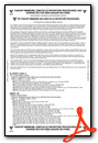
Weather Minimums
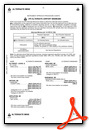
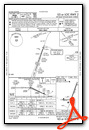
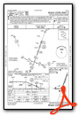
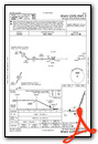
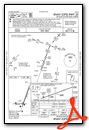
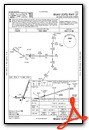
Instrument Approach Procedure (IAP) Charts
Nearby Airports with Instrument Procedures
| ID | Name | Heading / Distance | ||
|---|---|---|---|---|
 |
KARR | Aurora Municipal Airport | 133° | 14.2 |
|
KRPJ | Rochelle Municipal/Koritz Field Airport | 261° | 16.9 |
|
KDPA | Dupage Airport | 094° | 20.6 |
|
KRFD | Chicago/Rockford International Airport | 312° | 23.5 |
|
3CK | Lake In The Hills Airport | 046° | 23.7 |
|
C77 | Poplar Grove Airport | 346° | 24.1 |
|
1C5 | Bolingbrook's Clow International Airport | 118° | 29.5 |
|
10C | Galt Field Airport | 027° | 31.8 |
|
C09 | Morris Municipal - James R Washburn Field Airport | 156° | 33.1 |
|
KLOT | Lewis University Airport | 125° | 33.6 |
|
C73 | Dixon Municipal-Charles R Walgreen Field Airport | 259° | 33.7 |
|
KORD | Chicago O'Hare International Airport | 085° | 35.8 |
Airport Images

By: 2flaps
 from the south")
By: keeganmiller


