Login
Register


DLN
Dillon Airport
Official FAA Data Effective 2024-04-18 0901Z
Chart Supplement

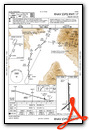
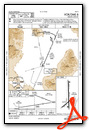
VFR Chart of KDLN
Sectional Charts at SkyVector.com
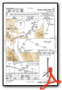
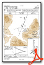
IFR Chart of KDLN
Enroute Charts at SkyVector.com
Location Information for KDLN
Coordinates: N45°15.32' / W112°33.15'Located 04 miles NE of Dillon, Montana on 202 acres of land. View all Airports in Montana.
Surveyed Elevation is 5244 feet MSL.
Operations Data
|
|
Airport Communications
| ASOS: | 135.225 Tel. 406-683-5470 |
|---|---|
| CTAF: | 122.800 |
| UNICOM: | 122.800 |
| AWOS-3PT at RVF (20.5 NE): | 119.025 406-684-5285 |
| AWOS-3P at EKS (38.3 E): | 119.85 406-682-3835 |
| ASOS at BTM (42.1 N): | 135.175 406-494-1870 |
- APCH/DEP CTL SVC PRVDD BY SALT LAKE ARTCC (ZLC) ON FREQS 132.4/338.3 (BOZEMAN RCAG).
Nearby Navigation Aids
|
| ||||||||||||||||||||||||||||||||||||||||||||||||


Runway 17/35
| Dimensions: | 6501 x 75 feet / 1982 x 23 meters | |
|---|---|---|
| Surface: | Asphalt in Good Condition | |
| Weight Limits: | 23 /F/D/X/U, S-58, D-75, ST-129 | |
| Edge Lighting: | Medium Intensity | |
| Runway 17 | Runway 35 | |
| Coordinates: | N45°15.97' / W112°33.15' | N45°14.90' / W112°33.11' |
| Elevation: | 5156.7 | 5244.7 |
| Traffic Pattern: | Left | Left |
| Runway Heading: | 179° True | 359° True |
| Markings: | Non-Precision Instrument in good condition. | Non-Precision Instrument in good condition. |
| Glide Slope Indicator | P2L (3.00° Glide Path Angle) | P2L (3.00° Glide Path Angle) |
Runway 04/22
| Dimensions: | 3600 x 60 feet / 1097 x 18 meters | |
|---|---|---|
| Surface: | Asphalt in Good Condition | |
| Weight Limits: | 5 /F/D/Y/U, S-12 | |
| Edge Lighting: | Medium Intensity | |
| Runway 04 | Runway 22 | |
| Coordinates: | N45°14.93' / W112°33.51' | N45°15.31' / W112°32.86' |
| Elevation: | 5221.5 | 5226.9 |
| Traffic Pattern: | Left | Left |
| Runway Heading: | 50° True | 230° True |
| Markings: | Basic in good condition. | Basic in good condition. |
| Glide Slope Indicator | P2L (3.00° Glide Path Angle) | |
| Obstacles: | 5 ft Road 254 ft from runway, 130 ft right of center | 16 ft Road 450 ft from runway, 250 ft left of center |
Services Available
| Fuel: | 100LL (blue), Jet-A |
|---|---|
| Transient Storage: | Hangars,Tiedowns |
| Airframe Repair: | MAJOR |
| Engine Repair: | MAJOR |
| Bottled Oxygen: | NOT AVAILABLE |
| Bulk Oxygen: | NOT AVAILABLE |
| Other Services: | CHARTER SERVICE,PILOT INSTRUCTION,AIRCRAFT RENTAL,ANNUAL SURVEYING |
Ownership Information
| Ownership: | Publicly owned | |
|---|---|---|
| Owner: | BEAVERHEAD COUNTY | |
| 2 S. PACIFIC ST | ||
| DILLON, MT 59725-2799 | ||
| 406-683-5242 | ||
| Manager: | RANDY BAILEY | |
| 2400 AIRPORT ROAD | ||
| DILLON, MT 59725 | ||
| 406-683-5242 | ||
Operational Statistics
| Single Engine Aircraft Based on Field: | 17 | Statistics collected for 12 month period ending 2019-06-24 | |
|---|---|---|---|
| Multi-Engine Aircraft Based on Field: | 1 | Annual Commercial Operations: | none |
| Jet Aircraft Based on Field: | none | Annual Commuter Operations: | none |
| Helicopters Based on Field: | 1 | Annual Air Taxi Operations: | 850 |
| Military Aircraft Based on Field: | none | Annual Military Operations: | 48 |
| Gliders Based on Field: | none | Annual GA Local Operations: | 3550 |
| Ultralights Based on Field: | none | Annual GA Itinerant Operations: | 1000 |
Other Remarks
- RWY VISIBILITY BLOCKED BY HNGRS/BLDGS ON RWY 17; CONFIRM PRESENCE OF OTHER ACFT PRIOR TO TKOF.
- ALL DEPARTURES PROHIBITED ON RWY 04 DUE TO RWY VISIBILITY BLOCKED BY HNGRS/BLDGS.
- FOR CD IF UNA TO CTC ON FSS FREQ, CTC SALT LAKE ARTCC AT 801-320-2568.
- RWY 17 1000 FT DISTANCE MARKERS, RWY 35 1000 FT DISTANCE MARKERS.
- ACTVT PAPI RWY 17, 22, & 35; MIRL RWY 04/22 & 17/35 - CTAF.
Weather Minimums
Instrument Approach Procedure (IAP) Charts
Nearby Airports with Instrument Procedures
| ID | Name | Heading / Distance | ||
|---|---|---|---|---|
 |
KRVF | Ruby Valley Field Airport | 032° | 19.9 |
|
KEKS | Ennis Big Sky Airport | 087° | 38.3 |
|
KBTM | Bert Mooney Airport | 003° | 42.0 |
|
3U3 | Bowman Field Airport | 346° | 55.5 |
|
KSMN | Lemhi County Airport | 262° | 56.9 |
|
KBZN | Bozeman Yellowstone International Airport | 061° | 66.9 |
|
38S | Deer Lodge-City-County Airport | 352° | 68.5 |
|
KWYS | Yellowstone Airport | 118° | 69.9 |
|
KHLN | Helena Regional Airport | 016° | 84.5 |
|
KHRF | Ravalli County Airport | 312° | 89.3 |
|
KRXE | Rexburg-Madison County Airport | 159° | 91.1 |
|
KLVM | Mission Field Airport | 072° | 92.8 |
Airport Images
Do you have a recent image of this airport? Upload it here!


