Login
Register


DLO
Delano Municipal Airport
Official FAA Data Effective 2024-04-18 0901Z
Chart Supplement

VFR Chart of KDLO
Sectional Charts at SkyVector.com
IFR Chart of KDLO
Enroute Charts at SkyVector.com
Location Information for KDLO
Coordinates: N35°44.73' / W119°14.19'Located 02 miles SE of Delano, California on 546 acres of land. View all Airports in California.
Surveyed Elevation is 316 feet MSL.
Operations Data
|
|
Airport Communications
| AWOS-3P: | 119.55 Tel. 661-721-2668 |
|---|---|
| BAKERSFIELD APPROACH: | 118.9 |
| BAKERSFIELD DEPARTURE: | 118.9 |
| CTAF: | 122.800 |
| UNICOM: | 122.800 |
| AWOS-3 at MIT (14.5 S): | 121.125 661-393-8596 |
| AWOS-3PT at PTV (18.9 NE): | 134.625 559-784-3874 |
| ATIS at BFL (20.7 SE): | 118.6 |
- APCH/DEP CTL SVC PRVDD BY LOS ANGELES ARTCC (ZLA) ON FREQS 127.1/317.7 (BAKERSFIELD RCAG) WHEN BAKERSFIELD APCH CTL (BFL) CLSD.
Nearby Navigation Aids
|
| ||||||||||||||||||||||||||||||||||||||||||||||||


Runway 14/32
| Dimensions: | 5659 x 75 feet / 1725 x 23 meters | |
|---|---|---|
| Surface: | Asphalt in Good Condition | |
| Weight Limits: | S-30 | |
| Edge Lighting: | Medium Intensity | |
| Runway 14 | Runway 32 | |
| Coordinates: | N35°45.17' / W119°14.40' | N35°44.30' / W119°13.98' |
| Elevation: | 316.1 | 312.6 |
| Traffic Pattern: | Right | Left |
| Runway Heading: | 159° True | 339° True |
| Displaced Threshold: | 1629 Feet | |
| Markings: | Non-Precision Instrument in good condition. | Non-Precision Instrument in good condition. |
| Glide Slope Indicator | P2L (3.50° Glide Path Angle) | P2L (3.00° Glide Path Angle) |
| REIL: | Yes | Yes |
| Obstacles: | 15 ft Road 200 ft from runway, 130 ft right of center APCH RATIO 50:1 TO DSPLCD THR. |
|
Services Available
| Fuel: | 100LL (blue) |
|---|---|
| Transient Storage: | Tiedowns |
| Airframe Repair: | MINOR |
| Engine Repair: | MAJOR |
| Bottled Oxygen: | NONE |
| Bulk Oxygen: | NONE |
| Other Services: | PILOT INSTRUCTION |
Ownership Information
| Ownership: | Publicly owned | |
|---|---|---|
| Owner: | CITY OF DELANO | |
| 1015 11TH AVE. | ||
| DELANO, CA 93215 | ||
| 661-761-3303 | ||
| Manager: | ROMAN DOWLING | |
| P.O. BOX 3010 | ||
| DELANO, CA 93215-3010 | ||
| 661-720-2219 | ||
Operational Statistics
| Single Engine Aircraft Based on Field: | 11 | Statistics collected for 12 month period ending 2023-06-01 | |
|---|---|---|---|
| Multi-Engine Aircraft Based on Field: | 3 | Annual Commercial Operations: | none |
| Jet Aircraft Based on Field: | none | Annual Commuter Operations: | none |
| Helicopters Based on Field: | none | Annual Air Taxi Operations: | none |
| Military Aircraft Based on Field: | none | Annual Military Operations: | none |
| Gliders Based on Field: | none | Annual GA Local Operations: | 8000 |
| Ultralights Based on Field: | none | Annual GA Itinerant Operations: | 11000 |
Other Remarks
- SEASONAL CROP DUSTER OPNS ON ARPT E OF RY 14/32. AREA E OF RY IS RSTRD AGRICULTURAL USE ONLY.
- AFTER HRS EMERGENCY CTC POLICE DEPT (661) 721-3377.
- (E81) RY 14/32 RY EXIT LGTS.
- FOR CD CTC LOS ANGELES ARTCC AT 661-575-2079.
- MIRL RWY 14/32 PRESET LOW INTST SS-SR; TO INCR INTST ACTVT - CTAF.
Weather Minimums
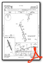
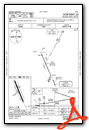
Instrument Approach Procedure (IAP) Charts
Nearby Airports with Instrument Procedures
| ID | Name | Heading / Distance | ||
|---|---|---|---|---|
 |
KMIT | Shafter-Minter Field Airport | 171° | 14.4 |
|
KPTV | Porterville Municipal Airport | 026° | 19.0 |
|
KBFL | Meadows Field Airport | 154° | 20.6 |
|
KTLR | Mefford Field Airport | 349° | 25.0 |
|
L45 | Bakersfield Municipal Airport | 154° | 27.8 |
|
KVIS | Visalia Municipal Airport | 347° | 35.2 |
|
KHJO | Hanford Municipal Airport | 331° | 39.2 |
|
O32 | Reedley Municipal Airport | 349° | 56.4 |
|
C80 | New Coalinga Municipal Airport | 296° | 57.3 |
|
KFCH | Fresno Chandler Exec Airport | 334° | 65.6 |
|
KFAT | Fresno Yosemite International Airport | 339° | 66.1 |
|
KMHV | Mojave Air & Space Port/Rutan Field Airport | 127° | 67.3 |
Airport Images

By: Skydog222

By: Skydog222


