Login
Register


DRO
Durango-La Plata County Airport
Official FAA Data Effective 2024-04-18 0901Z
Chart Supplement

VFR Chart of KDRO
Sectional Charts at SkyVector.com
IFR Chart of KDRO
Enroute Charts at SkyVector.com
Location Information for KDRO
Coordinates: N37°9.09' / W107°45.23'Located 10 miles SE of Durango, Colorado on 1281 acres of land. View all Airports in Colorado.
Surveyed Elevation is 6689 feet MSL.
Operations Data
|
|
Airport Communications
| ASOS: | 120.625 Tel. 970-259-3579 |
|---|---|
| UNICOM: | 122.800 |
| CTAF: | 122.800 |
| ASOS at FMN (33.5 SW): | 127.15 505-325-9268 |
| ATIS at FMN (33.6 SW): | 127.15 |
| AWOS-3 at PSO (34.4 E): | 127.175 970-731-0365 |
- APCH/DEP CTL SVC PRVDD BY DENVER ARTCC (ZDV) ON FREQS 118.575/348.7 (DURANGO RCAG).
Nearby Navigation Aids
|
| ||||||||||||||||||||||||||||||||||||


Runway 03/21
| Dimensions: | 9201 x 150 feet / 2804 x 46 meters | |
|---|---|---|
| Surface: | Asphalt / Grooved in Good Condition | |
| Weight Limits: | 59 /F/C/X/T, S-95, D-150, ST-210 | |
| Edge Lighting: | High Intensity | |
| Runway 03 | Runway 21 | |
| Coordinates: | N37°8.49' / W107°45.80' | N37°9.69' / W107°44.65' |
| Elevation: | 6619.7 | 6689.3 |
| Traffic Pattern: | Left | Left |
| Runway Heading: | 37° True | 217° True |
| Declared Distances: | TORA:9201 TODA:9201 ASDA:9201 LDA:9201 | TORA:9201 TODA:9201 ASDA:9201 LDA:9201 |
| Markings: | Precision Instrument in good condition. | Precision Instrument in good condition. |
| Glide Slope Indicator | P4L (3.00° Glide Path Angle) | P4L (3.00° Glide Path Angle) |
| Approach Lights: | MALSR 1,400 Foot Medium-intensity Approach Lighting System with runway alignment indicator lights. | |
| REIL: | Yes | |
Services Available
| Fuel: | 100LL (blue), Jet-A |
|---|---|
| Transient Storage: | Hangars,Tiedowns |
| Airframe Repair: | MAJOR |
| Engine Repair: | MAJOR |
| Bottled Oxygen: | LOW |
| Bulk Oxygen: | NOT AVAILABLE |
| Other Services: | AIR FREIGHT SERVICES,AIR AMBULANCE SERVICES,CHARTER SERVICE |
Ownership Information
| Ownership: | Publicly owned | |
|---|---|---|
| Owner: | DURANGO CITY LA PLATA CO | |
| 1000 AIRPORT ROAD BOX 15 | ||
| DURANGO, CO 81303 | ||
| 970-382-6050 | ||
| Manager: | ANTHONY VICARI - DIR OF AVIATION | |
| 1000 AIRPORT ROAD BOX 15 | ||
| DURANGO, CO 81303 | ||
| (970) 382-6051 | ||
Operational Statistics
| Single Engine Aircraft Based on Field: | 58 | Statistics collected for 12 month period ending 2023-07-31 | |
|---|---|---|---|
| Multi-Engine Aircraft Based on Field: | 12 | Annual Commercial Operations: | 7652 |
| Jet Aircraft Based on Field: | 6 | Annual Commuter Operations: | none |
| Helicopters Based on Field: | 3 | Annual Air Taxi Operations: | 1488 |
| Military Aircraft Based on Field: | none | Annual Military Operations: | 72 |
| Gliders Based on Field: | 2 | Annual GA Local Operations: | 2685 |
| Ultralights Based on Field: | none | Annual GA Itinerant Operations: | 8503 |
Other Remarks
- COND UNMNT AT NGT AFT LAST ACR ARR UNTIL 0400; SEE NOTAMS.
- ARFF COVERAGE PRVDD DURG ACR TFC OPS; OTR TIMES 24 HR PPR - ARPT OPS 970-759-4342.
- HOP ON & INVOF ARPT.
- FOR CD CTC DENVER ARTCC ON FREQ. IF UNA, CTC FSS ON FREQ VIA RCO. IF UNA, CTC DENVER ARTCC AT 303-651-4257.
- MALSR RWY 03; REIL RWY 21; HIRL RWY 03/21 OPER ON PHOTOCELL; INCR/DECR INTST - CTAF. PAPI RWY 03 & 21 ON CONSLY; INCR/DECR INTST - CTAF.
Weather Minimums
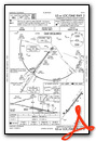
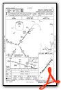
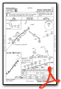
Instrument Approach Procedure (IAP) Charts
Nearby Airports with Instrument Procedures
| ID | Name | Heading / Distance | ||
|---|---|---|---|---|
 |
KFMN | Four Corners Regional Airport | 223° | 33.6 |
|
KPSO | Stevens Field Airport | 076° | 34.4 |
|
KCEZ | Cortez Municipal Airport | 282° | 42.9 |
|
KTEX | Telluride Regional Airport | 351° | 48.6 |
|
KRCV | Astronaut Kent Rominger Airport | 062° | 75.0 |
|
KAIB | Hopkins Field Airport | 329° | 75.7 |
|
KMTJ | Montrose Regional Airport | 355° | 81.7 |
|
KMVI | Monte Vista Municipal Airport | 074° | 84.8 |
|
KBDG | Blanding Municipal Airport | 287° | 86.7 |
|
U64 | Monticello Airport | 302° | 89.0 |
|
KALS | San Luis Valley Regional/Bergman Field Airport | 078° | 91.9 |
|
KGUC | Gunnison-Crested Butte Regional Airport | 024° | 91.6 |
Airport Images

By: animas


