Login
Register


DVK
Stuart Powell Field Airport
Official FAA Data Effective 2024-04-18 0901Z
Chart Supplement

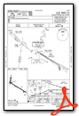
VFR Chart of KDVK
Sectional Charts at SkyVector.com
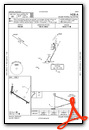
IFR Chart of KDVK
Enroute Charts at SkyVector.com
Location Information for KDVK
Coordinates: N37°34.65' / W84°46.17'Located 03 miles S of Danville, Kentucky on 170 acres of land. View all Airports in Kentucky.
Surveyed Elevation is 1022 feet MSL.
Operations Data
|
|
Airport Communications
| AWOS-3: | 128.325 Tel. 859-854-0058 |
|---|---|
| LEXINGTON APPROACH: | 120.15 259.3 |
| LEXINGTON DEPARTURE: | 120.15 259.3 |
| CTAF: | 122.800 |
| UNICOM: | 122.800 |
| AWOS-3 at RGA (21.0 E): | 119.625 859-985-5969 |
| AWOS-3P at 6I2 (22.7 W): | 119.725 859-336-0340 |
| ASOS at LEX (28.6 N): | 126.3 859-281-5700 |
Nearby Navigation Aids
|
| ||||||||||||||||||||||||||||||||||||||||||||||||||||||||||||


Runway 13/31
| Dimensions: | 5000 x 75 feet / 1524 x 23 meters | |
|---|---|---|
| Surface: | Asphalt in Fair Condition | |
| Weight Limits: | 23 /F/D/X/T, S-30 | |
| Edge Lighting: | Medium Intensity | |
| Runway 13 | Runway 31 | |
| Coordinates: | N37°34.79' / W84°46.50' | N37°34.36' / W84°45.62' |
| Elevation: | 1014.5 | 1015.5 |
| Traffic Pattern: | Left | Left |
| Runway Heading: | 122° True | 302° True |
| Markings: | Non-Precision Instrument in good condition. | Non-Precision Instrument in good condition. |
| Glide Slope Indicator | P4L (3.00° Glide Path Angle) | P4L (3.00° Glide Path Angle) |
| REIL: | Yes | |
| Obstacles: | 45 ft Trees 467 ft from runway, 250 ft right of center | |
Runway 01/19
| Dimensions: | 1971 x 75 feet / 601 x 23 meters | |
|---|---|---|
| Surface: | Asphalt / Rubberized Friction Seal Coated in Excellent Condition | |
| Weight Limits: | S-12 | |
| Runway 01 | Runway 19 | |
| Coordinates: | N37°34.69' / W84°46.47' | N37°35.02' / W84°46.41' |
| Elevation: | 1013.6 | 1021.3 |
| Runway Heading: | 8° True | 188° True |
| Displaced Threshold: | 162 Feet | |
| Markings: | Basic in good condition. | Basic in good condition. |
| Obstacles: | 48 ft Trees 542 ft from runway, 87 ft left of center WIND CONE ON HNGR. 6 FT FENCE 196 FT FM THR. |
27 ft Hangar 429 ft from runway, 107 ft right of center 21:1 TO DTHR. |
Services Available
| Fuel: | 100LL (blue), Jet A+ |
|---|---|
| Transient Storage: | Hangars,Tiedowns |
| Airframe Repair: | MAJOR |
| Engine Repair: | MAJOR |
| Bottled Oxygen: | NONE |
| Bulk Oxygen: | NONE |
| Other Services: | AIR AMBULANCE SERVICES,CARGO HANDLING SERVICES,CHARTER SERVICE,PILOT INSTRUCTION,AIRCRAFT RENTAL |
Ownership Information
| Ownership: | Publicly owned | |
|---|---|---|
| Owner: | CITY OF DANVILLE & BOYLE COUNTY | |
| CITY HALL | ||
| DANVILLE, KY 40422-9424 | ||
| 859-236-8917 | ROB CALDWELL 859-319-9414. | |
| Manager: | CHRISTIAN BARKER | NICK BARKER 859-853-1701 |
| 420 AIRPORT ROAD | ||
| DANVILLE, KY 40422-9424 | ||
| 859-854-5994 | ||
Operational Statistics
| Single Engine Aircraft Based on Field: | 52 | Statistics collected for 12 month period ending 2021-04-13 | |
|---|---|---|---|
| Multi-Engine Aircraft Based on Field: | 4 | Annual Commercial Operations: | none |
| Jet Aircraft Based on Field: | 5 | Annual Commuter Operations: | none |
| Helicopters Based on Field: | 6 | Annual Air Taxi Operations: | 3570 |
| Military Aircraft Based on Field: | none | Annual Military Operations: | 420 |
| Gliders Based on Field: | none | Annual GA Local Operations: | 7000 |
| Ultralights Based on Field: | none | Annual GA Itinerant Operations: | 11495 |
Other Remarks
- FOR CD CTC LEXINGTON APPROACH AT 859-514-7890.
- ACTVT REIL RWY 31; PAPI RWY 13 & 31; MIRL RWY 13/31 - CTAF.
Weather Minimums
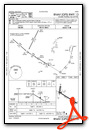
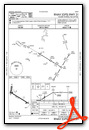
Instrument Approach Procedure (IAP) Charts
Nearby Airports with Instrument Procedures
| ID | Name | Heading / Distance | ||
|---|---|---|---|---|
 |
KRGA | Central Kentucky Regional Airport | 081° | 21.1 |
|
6I2 | Lebanon Springfield-George Hoerter Field Airport | 278° | 22.8 |
|
KLEX | Blue Grass Airport | 015° | 28.6 |
|
KAAS | Taylor County Airport | 243° | 28.9 |
|
KSME | Lake Cumberland Regional Airport | 166° | 32.3 |
|
KFFT | Capital City Airport | 349° | 36.8 |
|
KBRY | Samuels Field Airport | 292° | 37.6 |
|
K24 | Russell County Airport | 205° | 37.6 |
|
27K | Georgetown-Scott County Regional Airport | 021° | 42.5 |
|
KEKQ | Wayne County Airport | 185° | 43.5 |
|
KLOZ | London/Corbin/Magee Airport | 131° | 44.3 |
|
KIOB | Mount Sterling/Montgomery County Airport | 052° | 47.3 |
Airport Images
Do you have a recent image of this airport? Upload it here!


Comments
Runway 30 and 12
Incorrect on the charts and on ForeFlight Correct runways are 31 and 13