Login
Register


DVT
Phoenix Deer Valley Airport
Official FAA Data Effective 2024-03-21 0901Z
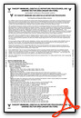
From the Flight Deck
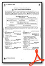
Chart Supplement

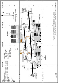
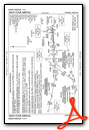
KDVT Airport Diagram
VFR Chart of KDVT
Sectional Charts at SkyVector.com
IFR Chart of KDVT
Enroute Charts at SkyVector.com
Location Information for KDVT
Coordinates: N33°41.30' / W112°4.95'Located 15 miles N of Phoenix, Arizona on 914 acres of land. View all Airports in Arizona.
Surveyed Elevation is 1478 feet MSL.
TPA-2500 (1022) PISTON ENGINE AND 3000 (1522) TURBINE ENGINE.
Operations Data
|
|
Airport Communications
| ATIS: | 126.5 |
|---|---|
| ASOS: | 126.5 Tel. 623-587-7764 |
| DEER VALLEY TOWER: | 118.4 ;ARR FM 070-250 AND RWY 07R/25L DEP 120.2 ;ARR FM 251-069 AND RWY 07L/25R DEP, 0600-0000 FT |
| DEER VALLEY GROUND: | 121.8 |
| PHOENIX APPROACH: | 120.7 239.0 |
| PHOENIX DEPARTURE: | 120.7 239.0 |
| CLEARANCE DELIVERY: | 123.9 |
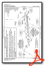
| SUNSS STAR: | 124.1 256.9 |
| CTAF: | 118.400 |
| UNICOM: | 122.950 |
| DSERT STAR: | 120.7 |
| BLYTHE STAR: | 124.1 |
| ATIS at SDL (9.5 SE): | 118.6 |
| ASOS at SDL (9.5 SE): | 480-483-3049 |
| AWOS-1 at 18AZ (12.1 NE): | 125.625 480-488-7882 |
- EMERG FREQ 121.5 NOT AVBL AT ATCT.
Nearby Navigation Aids
|
| ||||||||||||||||||||||||||||||||||||

Runway 07R/25L
| Dimensions: | 8196 x 100 feet / 2498 x 30 meters | |
|---|---|---|
| Surface: | Asphalt in Good Condition | |
| Weight Limits: | 29 /F/C/Y/T, S-20, D-91, ST-255 | |
| Edge Lighting: | Medium Intensity | |
| Runway 07R | Runway 25L | |
| Coordinates: | N33°41.21' / W112°5.78' | N33°41.30' / W112°4.16' |
| Elevation: | 1439.9 | 1478.1 |
| Traffic Pattern: | Right | Left |
| Runway Heading: | 86° True | 266° True |
| Displaced Threshold: | 898 Feet | 916 Feet |
| Declared Distances: | TORA:8196 TODA:8196 ASDA:8196 LDA:7299 | TORA:8196 TODA:8196 ASDA:8196 LDA:7281 |
| Markings: | Non-Precision Instrument in good condition. | Non-Precision Instrument in good condition. |
| Glide Slope Indicator | P4L (3.00° Glide Path Angle) | P4L (3.00° Glide Path Angle) UNUSBL BYD 5-DEGS LEFT OF CTRLN AND 6-DEGS RIGHT OF CTRLN. |
| REIL: | Yes | Yes |
| Obstacles: | 38 ft Sign 1257 ft from runway, 359 ft right of center APCH SLOPE 50:1 AT DTHR. |
76 ft Hill 2527 ft from runway, 565 ft left of center APCH SLOPE 50:1 AT DTHR. |
Runway 07L/25R
TRNG RWY. | ||
| Dimensions: | 4500 x 75 feet / 1372 x 23 meters | |
|---|---|---|
| Surface: | Asphalt in Good Condition | |
| Weight Limits: | 50 /F/C/Y/T, S-70, D-117 | |
| Edge Lighting: | Medium Intensity | |
| Runway 07L | Runway 25R | |
| Coordinates: | N33°41.35' / W112°5.37' | N33°41.40' / W112°4.48' |
| Elevation: | 1455.1 | 1476.8 |
| Traffic Pattern: | Left | Right |
| Runway Heading: | 86° True | 266° True |
| Markings: | Non-Precision Instrument in good condition. | Non-Precision Instrument in good condition. |
| Glide Slope Indicator | P4L (3.50° Glide Path Angle) | P4L (4.00° Glide Path Angle) |
| REIL: | Yes | Yes |
| Obstacles: | 180 ft Hill 3732 ft from runway, 122 ft left of center | |
Services Available
| Fuel: | 100LL (blue), Jet A+ |
|---|---|
| Transient Storage: | Hangars,Tiedowns CALL AHEAD FOR AVBLTY - 623-581-1444. |
| Airframe Repair: | MAJOR |
| Engine Repair: | MAJOR |
| Bottled Oxygen: | HIGH |
| Bulk Oxygen: | HIGH |
| Other Services: | AIR AMBULANCE SERVICES,AVIONICS,CHARTER SERVICE,PILOT INSTRUCTION,AIRCRAFT RENTAL,AIRCRAFT SALES |
Ownership Information
| Ownership: | Publicly owned | |
|---|---|---|
| Owner: | CITY OF PHOENIX | |
| 3400 SKY HARBOR BLVD | ||
| PHOENIX, AZ 85034 | ||
| 623-869-0975 | ||
| Manager: | ED FARON | |
| 702 W DEER VALLEY DR | ||
| PHOENIX, AZ 85027 | ||
| 623-869-0975 | EMERG - 623-869-0977. | |
Operational Statistics
| Single Engine Aircraft Based on Field: | 754 | Statistics collected for 12 month period ending 2020-12-31 | |
|---|---|---|---|
| Multi-Engine Aircraft Based on Field: | 84 | Annual Commercial Operations: | 10 |
| Jet Aircraft Based on Field: | 18 | Annual Commuter Operations: | none |
| Helicopters Based on Field: | 21 | Annual Air Taxi Operations: | 4963 |
| Military Aircraft Based on Field: | 2 | Annual Military Operations: | 142 |
| Gliders Based on Field: | 10 | Annual GA Local Operations: | 139066 |
| Ultralights Based on Field: | 2 | Annual GA Itinerant Operations: | 258263 |
Other Remarks
- CTN: LGTD HILLS NE, E, SE & W; HOT AIR BLN OPS N, NE & NW; PILOT TRNG WI 20 NM; AEROBATIC PRACTICE AREA 8.5 MI NW; SFC-6000 MSL.
- SPL ATC RULE (SATR) IN EFCT W OF ARPT; CK SECTIONAL/TAC.
- TWY D1 & D13 RUNUP PADS CLSD TO WINGSPAN MORE THAN 49 FT.
- FOR CD WHEN ATCT CLSD, CTC PHOENIX APCH AT 602-306-2565.
- CHARTER, TRAVEL CLUB & REVENUE ACFT FEE.
- BIRDS & WILDLIFE ON & INVOF ARPT.
- 0LL CREDIT CARD SELF SVC AVBL H24.
- WHEN ATCT CLSD, REIL RWY 07R, 07L, 25R & 25L; PAPI RWY 07R, 07L, 25R & 25L; MIRL RWY 07R/25L & 07L/25R ON CONSLY.
- TPA-2500 (1022) PISTON ENGINE AND 3000 (1522) TURBINE ENGINE.
Weather Minimums
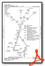
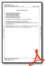
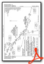
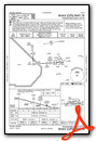
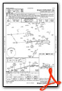
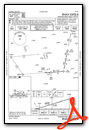
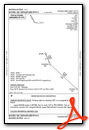
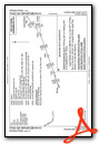
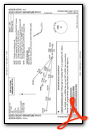
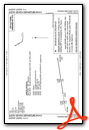
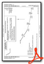
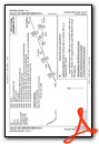
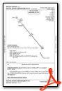
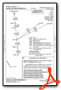
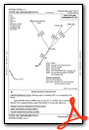
Standard Terminal Arrival (STAR) Charts
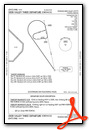
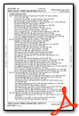
Instrument Approach Procedure (IAP) Charts
Departure Procedure (DP) Charts
Departure Procedure Obstacles (DPO) Charts
Nearby Airports with Instrument Procedures
| ID | Name | Heading / Distance | ||
|---|---|---|---|---|
 |
KSDL | Scottsdale Airport | 114° | 9.5 |
|
KGEU | Glendale Municipal Airport | 227° | 14.4 |
|
KPHX | Phoenix Sky Harbor International Airport | 166° | 15.6 |
|
KLUF | Luke AFB Airport | 238° | 17.6 |
|
KGYR | Phoenix Goodyear Airport | 222° | 21.6 |
|
KFFZ | Falcon Field Airport | 127° | 22.4 |
|
P19 | Stellar Airpark Airport | 160° | 24.8 |
|
KCHD | Chandler Municipal Airport | 151° | 28.6 |
|
KIWA | Phoenix-Mesa Gateway Airport | 136° | 31.3 |
|
KCGZ | Casa Grande Municipal Airport | 160° | 46.7 |
|
KPAN | Payson Airport | 047° | 50.4 |
|
P08 | Coolidge Municipal Airport | 143° | 55.8 |


