Login
Register


EFC
Belle Fourche Municipal Airport
Official FAA Data Effective 2024-04-18 0901Z
Chart Supplement

VFR Chart of KEFC
Sectional Charts at SkyVector.com
IFR Chart of KEFC
Enroute Charts at SkyVector.com
Location Information for KEFC
Coordinates: N44°44.07' / W103°51.71'Located 04 miles N of Belle Fourche, South Dakota on 279 acres of land. View all Airports in South Dakota.
Surveyed Elevation is 3190 feet MSL.
Operations Data
|
|
Airport Communications
| UNICOM: | 122.800 |
|---|---|
| CTAF: | 122.800 |
| AWOS-3 at SPF (15.6 S): | 118.325 605-642-8536 |
| AWOS-3P at 49B (28.0 SE): | 119.275 605-347-3356 |
| AWOS-3PT at W43 (30.4 W): | 128.775 307-467-5575 |
- APCH/DEP CTL SVC PRVDD BY DENVER ARTCC (ZDV) ON FREQS 127.95/338.2 (CRAWFORD RCAG).
Nearby Navigation Aids
|
| ||||||||||||||||||||||||||||||||||||||||||


Runway 14/32
| Dimensions: | 4501 x 60 feet / 1372 x 18 meters | |
|---|---|---|
| Surface: | Asphalt in Good Condition | |
| Weight Limits: | S-12 | |
| Edge Lighting: | Medium Intensity | |
| Runway 14 | Runway 32 | |
| Coordinates: | N44°44.38' / W103°51.96' | N44°43.72' / W103°51.48' |
| Elevation: | 3169.9 | 3180.1 |
| Runway Heading: | 152° True | 332° True |
| Markings: | Non-Precision Instrument in fair condition. | Non-Precision Instrument in fair condition. |
| Glide Slope Indicator | P2L (3.00° Glide Path Angle) | P2L (3.00° Glide Path Angle) |
Runway 18/36
MARKED WITH WHITE/BLACK MARKER CONES. | ||
| Dimensions: | 3639 x 120 feet / 1109 x 37 meters | |
|---|---|---|
| Surface: | Turf in Good Condition | |
| Runway 18 | Runway 36 | |
| Coordinates: | N44°44.39' / W103°51.61' | N44°43.81' / W103°51.78' |
| Elevation: | 3190.6 | 3189.7 |
| Runway Heading: | 192° True | 12° True |
Services Available
| Fuel: | 100LL (blue), Jet-A |
|---|---|
| Transient Storage: | Hangars,Tiedowns |
| Airframe Repair: | MAJOR |
| Engine Repair: | MAJOR |
| Bottled Oxygen: | NOT AVAILABLE |
| Bulk Oxygen: | NOT AVAILABLE |
| Other Services: | CROP DUSTING SERVICES,GLIDER SERVICE,PILOT INSTRUCTION |
Ownership Information
| Ownership: | Publicly owned | |
|---|---|---|
| Owner: | CITY OF BELLE FOURCHE | |
| 511 6TH AVE. | ||
| BELLE FOURCHE, SD 57717 | ||
| 605-892-2494 | ||
| Manager: | JAMES DERANLEAU | |
| 10970 AIRPORT ROAD | ||
| BELLE FOURCHE, SD 57717 | ||
| 605-892-6345 | ||
Operational Statistics
| Single Engine Aircraft Based on Field: | 17 | Statistics collected for 12 month period ending 2023-07-25 | |
|---|---|---|---|
| Multi-Engine Aircraft Based on Field: | 1 | Annual Commercial Operations: | none |
| Jet Aircraft Based on Field: | none | Annual Commuter Operations: | none |
| Helicopters Based on Field: | none | Annual Air Taxi Operations: | none |
| Military Aircraft Based on Field: | none | Annual Military Operations: | 6 |
| Gliders Based on Field: | none | Annual GA Local Operations: | 3600 |
| Ultralights Based on Field: | none | Annual GA Itinerant Operations: | 600 |
Other Remarks
- ULTRALIGHT OPNS ON & INVOF ARPT.
- WATERFOWL ON AND INVOF ARPT.
- FOR CD CTC DENVER ARTCC AT 303-651-4257.
- HIGH VOL OF ACFT OPRNG INVOF OF MT RUSHMORE AND CRAZY HORSE MONUMENTS AT OR BLW 7500 FT; PILOTS ARE ADVISED TO MNT 122.85 FOR TFC ADVISORIES.
- ACTVT MIRL RWY 14/32 - CTAF.
- AUTOMATED UNICOM.
Weather Minimums
Instrument Approach Procedure (IAP) Charts
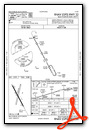
Nearby Airports with Instrument Procedures
| ID | Name | Heading / Distance | ||
|---|---|---|---|---|
 |
KSPF | Black Hills-Clyde Ice Field Airport | 167° | 15.6 |
|
49B | Sturgis Municipal Airport | 132° | 28.1 |
|
W43 | Hulett Municipal Airport | 262° | 30.5 |
|
KRCA | Ellsworth AFB Airport | 137° | 48.1 |
|
KRAP | Rapid City Regional Airport | 139° | 53.9 |
|
KECS | Mondell Field Airport | 201° | 54.6 |
|
KGCC | Northeast Wyoming Regional Airport | 252° | 75.6 |
|
KHSR | Hot Springs Municipal Airport | 165° | 84.5 |
|
KBWW | Bowman Regional Airport | 015° | 89.1 |
|
KHEI | Hettinger/Jb Lindquist Regional Airport | 033° | 92.2 |
|
KBHK | Baker Municipal Airport | 350° | 98.2 |
|
KLEM | Lemmon Municipal Airport | 045° | 102.8 |
Airport Images
Do you have a recent image of this airport? Upload it here!


