Login
Register


EHO
Shelby-Cleveland County Regional Airport
Official FAA Data Effective 2024-04-18 0901Z
Chart Supplement

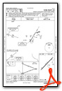
VFR Chart of KEHO
Sectional Charts at SkyVector.com
IFR Chart of KEHO
Enroute Charts at SkyVector.com
Location Information for KEHO
Coordinates: N35°15.34' / W81°36.05'Located 03 miles SW of Shelby, North Carolina on 225 acres of land. View all Airports in North Carolina.
Surveyed Elevation is 846 feet MSL.
Operations Data
|
|
Airport Communications
| AWOS-3: | 118.425 Tel. 704-487-0100 |
|---|---|
| CHARLOTTE APPROACH: | 120.05 257.2 |
| CHARLOTTE DEPARTURE: | 120.05 257.2 |
| UNICOM: | 122.800 |
| JOOLS STAR: | 135.6 377.15 |
| CTAF: | 122.800 |
| RASLN STAR: | 126.15 282.325 |
| AWOS-3 at FQD (19.4 NW): | 118.275 828-287-6498 |
| ASOS at AKH (22.1 E): | 135.725 704-868-9034 |
| AWOS-3 at IPJ (25.5 NE): | 119.675 704-735-6954 |
Nearby Navigation Aids
|
| ||||||||||||||||||||||||||||||||||||||||||||||||||||||||||||


Runway 05/23
| Dimensions: | 5001 x 100 feet / 1524 x 30 meters | |
|---|---|---|
| Surface: | Asphalt in Good Condition | |
| Weight Limits: | S-21 | |
| Edge Lighting: | Medium Intensity | |
| Runway 05 | Runway 23 | |
| Coordinates: | N35°15.05' / W81°36.39' | N35°15.64' / W81°35.70' |
| Elevation: | 833.8 | 836.8 |
| Traffic Pattern: | Left | Left |
| Runway Heading: | 44° True | 224° True |
| Markings: | Non-Precision Instrument in good condition. | Non-Precision Instrument in good condition. |
| Glide Slope Indicator | P2L (3.00° Glide Path Angle) | P2L (3.00° Glide Path Angle) |
| Obstacles: | 44 ft Trees 955 ft from runway, 307 ft right of center | 40 ft Trees 994 ft from runway, 38 ft left of center |
Services Available
| Fuel: | 100LL (blue), Jet A-1+ |
|---|---|
| Transient Storage: | Tiedowns |
| Airframe Repair: | MAJOR |
| Engine Repair: | MAJOR |
| Bottled Oxygen: | NONE |
| Bulk Oxygen: | NONE |
| Other Services: | PILOT INSTRUCTION,AIRCRAFT RENTAL |
Ownership Information
| Ownership: | Publicly owned | |
|---|---|---|
| Owner: | CITY OF SHELBY | |
| 830 COLLEGE AVE, HIGHWAY 150 | ||
| SHELBY, NC 28152 | ||
| 704-487-1161 | ||
| Manager: | JACK POOLE | |
| 830 COLLEGE AVE, HIGHWAY 150 | ||
| SHELBY, NC 28152 | ||
| 704-487-1161 | ||
Operational Statistics
| Single Engine Aircraft Based on Field: | 65 | Statistics collected for 12 month period ending 2023-07-02 | |
|---|---|---|---|
| Multi-Engine Aircraft Based on Field: | 6 | Annual Commercial Operations: | none |
| Jet Aircraft Based on Field: | 1 | Annual Commuter Operations: | none |
| Helicopters Based on Field: | none | Annual Air Taxi Operations: | none |
| Military Aircraft Based on Field: | none | Annual Military Operations: | 200 |
| Gliders Based on Field: | none | Annual GA Local Operations: | 10000 |
| Ultralights Based on Field: | none | Annual GA Itinerant Operations: | 8000 |
Other Remarks
- FOR SERVICE AFTER HOURS CALL 704 284-3321.
- RY 23 HAS 35 FT DROP-OFF 600 FT FM THLD 0B.
- RY 05 HAS 45 FT DROP-OFF 100 FT FM THLD 0B.
- FOR CD CTC CHARLOTTE APCH AT 704-359-0241.
- REFER TO CHARLOTTE SECTIONAL CHART FOR TOWERS OFF BOTH RWY ENDS.
- 0LL 100LL FUEL 24 HR CREDIT CARD SVC AVBL.
- DUSK-2300. AFTER 2300 ACTVT MIRL RWY 05/23 - CTAF. PAPI RWY 05 & 23 OPER CONSLY.
Weather Minimums

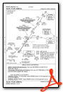
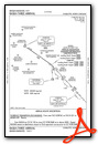
Standard Terminal Arrival (STAR) Charts
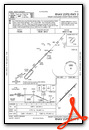
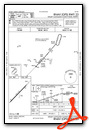
Instrument Approach Procedure (IAP) Charts
Nearby Airports with Instrument Procedures
| ID | Name | Heading / Distance | ||
|---|---|---|---|---|
 |
KFQD | Rutherford County/Marchman Field Airport | 302° | 19.4 |
|
KAKH | Gastonia Municipal Airport | 098° | 22.4 |
|
KIPJ | Lincolnton-Lincoln County Regional Airport | 057° | 25.5 |
|
KSPA | Spartanburg Downtown Memorial/Simpson Field Airport | 220° | 26.8 |
|
KHKY | Hickory Regional Airport | 019° | 30.9 |
|
KUZA | Rock Hill/York County/Bryant Field Airport | 120° | 31.2 |
|
KCLT | Charlotte/Douglas International Airport | 094° | 32.1 |
|
KMRN | Foothills Regional Airport | 359° | 33.8 |
|
35A | Union County, Troy Shelton Field Airport | 183° | 34.1 |
|
KDCM | Chester Catawba Regional Airport | 144° | 34.3 |
|
KGSP | Greenville Spartanburg International Airport | 234° | 37.3 |
|
14A | Lake Norman Airpark Airport | 057° | 40.5 |
Airport Images
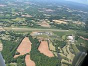
By: Big Orange Bird

By: airport@cityofs...


