Login
Register


ELO
Ely Municipal Airport
Official FAA Data Effective 2024-04-18 0901Z
Chart Supplement

VFR Chart of KELO
Sectional Charts at SkyVector.com
IFR Chart of KELO
Enroute Charts at SkyVector.com
Location Information for KELO
Coordinates: N47°49.44' / W91°49.76'Located 04 miles S of Ely, Minnesota on 560 acres of land. View all Airports in Minnesota.
Surveyed Elevation is 1456 feet MSL.
Operations Data
|
|
Airport Communications
| AWOS-3PT: | 132.025 Tel. 218-365-3814 |
|---|---|
| UNICOM: | 122.800 |
| CTAF: | 122.800 |
| AWOS-3 at CQM (34.7 W): | 118.175 218-666-2539 |
| AWOS-3 at EVM (36.1 SW): | 118.825 218-744-2369 |
| AWOS-3 at CDD (37.4 NW): | 118.2 218-993-2467 |
- APCH/DEP SVC PRVDD BY MINNEAPOLIS ARTCC (ZMP) ON FREQS 127.9/281.45 (DULUTH RCAG).
Nearby Navigation Aids
|
| ||||||||||||||||||||||||||||||||||||||||||||||||||||||||||||


Runway 12/30
| Dimensions: | 5596 x 100 feet / 1706 x 30 meters | |
|---|---|---|
| Surface: | Asphalt in Good Condition | |
| Weight Limits: | 39 /F/B/X/U, S-99, D-159 | |
| Edge Lighting: | Medium Intensity | |
| Runway 12 | Runway 30 | |
| Coordinates: | N47°49.67' / W91°50.35' | N47°49.21' / W91°49.17' |
| Elevation: | 1443.0 | 1455.6 |
| Traffic Pattern: | Left | Left |
| Runway Heading: | 120° True | 300° True |
| Markings: | Non-Precision Instrument in good condition. | Non-Precision Instrument in good condition. |
| Glide Slope Indicator | P4L (3.00° Glide Path Angle) | P4L (3.00° Glide Path Angle) |
| REIL: | Yes | Yes |
| Obstacles: | 90 ft Tree 2760 ft from runway, 616 ft left of center | |
Services Available
| Fuel: | 100LL (blue), Jet-A |
|---|---|
| Transient Storage: | Hangars,Tiedowns |
| Airframe Repair: | NONE |
| Engine Repair: | NONE |
| Bottled Oxygen: | NONE |
| Bulk Oxygen: | NONE |
Ownership Information
| Ownership: | Publicly owned | |
|---|---|---|
| Owner: | CITY OF ELY | |
| 209 E CHAPMAN ST | ||
| ELY, MN 55731-1471 | ||
| 218-365-3224 | ||
| Manager: | JIM PREBLICH | |
| 1583 HIGHWAY 1 | ||
| ELY, MN 55731-8209 | ||
| 218-365-5600 | ||
Operational Statistics
| Single Engine Aircraft Based on Field: | 22 | Statistics collected for 12 month period ending 2017-06-30 | |
|---|---|---|---|
| Multi-Engine Aircraft Based on Field: | none | Annual Commercial Operations: | none |
| Jet Aircraft Based on Field: | 1 | Annual Commuter Operations: | none |
| Helicopters Based on Field: | none | Annual Air Taxi Operations: | 200 |
| Military Aircraft Based on Field: | none | Annual Military Operations: | none |
| Gliders Based on Field: | none | Annual GA Local Operations: | 5000 |
| Ultralights Based on Field: | none | Annual GA Itinerant Operations: | 3000 |
Other Remarks
- FOR CD CTC MINNEAPOLIS ARTCC AT 651-463-5588.
- ACTVT OR INCR INTST REIL RWY 12 & 30; PAPI RWY 12 & 30; MIRL RWY 12/30 - CTAF. MIRL RWY 12/30 PRESET LOW INTST.
Weather Minimums
Instrument Approach Procedure (IAP) Charts
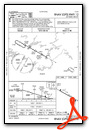
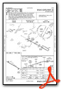
Nearby Airports with Instrument Procedures
| ID | Name | Heading / Distance | ||
|---|---|---|---|---|
 |
12D | Tower Municipal Airport | 269° | 18.5 |
|
KCQM | Cook Municipal Airport | 270° | 34.8 |
|
KEVM | Eveleth/Virginia Municipal Airport | 228° | 36.2 |
|
KORB | Orr Regional Airport | 285° | 43.0 |
|
KTWM | Richard B Helgeson Airport | 175° | 46.6 |
|
KHIB | Range Regional Airport | 237° | 48.7 |
|
KCKC | Grand Marais/Cook County Airport | 088° | 58.4 |
|
KDLH | Duluth International Airport | 194° | 60.8 |
|
KDYT | Sky Harbor Airport | 187° | 66.7 |
|
KSUW | Richard I Bong Airport | 189° | 69.0 |
|
KCOQ | Cloquet/Carlton County Airport | 202° | 72.8 |
|
KFOZ | Bigfork Municipal Airport | 268° | 73.7 |
Airport Images
Do you have a recent image of this airport? Upload it here!


