Login
Register


EOE
Newberry County Airport
Official FAA Data Effective 2024-04-18 0901Z
Chart Supplement

VFR Chart of KEOE
Sectional Charts at SkyVector.com
IFR Chart of KEOE
Enroute Charts at SkyVector.com
Location Information for KEOE
Coordinates: N34°18.56' / W81°38.44'Located 03 miles N of Newberry, South Carolina on 196 acres of land. View all Airports in South Carolina.
Surveyed Elevation is 570 feet MSL.
Operations Data
|
|
Airport Communications
| AWOS-3: | 124.275 Tel. 803-276-2419 |
|---|---|
| COLUMBIA APPROACH: | 133.4 285.6 |
| COLUMBIA DEPARTURE: | 133.4 285.6 |
| CTAF: | 122.800 |
| UNICOM: | 122.800 |
| AWOS-3 at LUX (19.3 NW): | 123.975 864-682-3639 |
| AWOS-3PT at 35A (22.5 N): | 119.45 864-427-1514 |
| ASOS at GRD (25.8 W): | 121.125 864-388-9115 |
Nearby Navigation Aids
|
| ||||||||||||||||||||||||||||||||||||||||||||||||||||||||||||


Runway 04/22
| Dimensions: | 4001 x 75 feet / 1220 x 23 meters | |
|---|---|---|
| Surface: | Asphalt / Aggregate Friction Seal Coated in Excellent Condition | |
| Weight Limits: | S-23, D-30 | |
| Edge Lighting: | Medium Intensity | |
| Runway 04 | Runway 22 | |
| Coordinates: | N34°18.30' / W81°38.68' | N34°18.82' / W81°38.20' |
| Elevation: | 535.6 | 570.1 |
| Traffic Pattern: | Left | Right |
| Runway Heading: | 37° True | 217° True |
| Markings: | Non-Precision Instrument in good condition. | Non-Precision Instrument in good condition. |
| Glide Slope Indicator | P2L (3.15° Glide Path Angle) | P2L (3.15° Glide Path Angle) |
| Obstacles: | 96 ft Trees 2379 ft from runway, 271 ft right of center | 34 ft Pole 1025 ft from runway, 191 ft left of center |
Services Available
| Fuel: | 100LL (blue) |
|---|---|
| Transient Storage: | Tiedowns |
| Airframe Repair: | MAJOR |
| Engine Repair: | MAJOR |
| Bottled Oxygen: | NONE |
| Bulk Oxygen: | NONE |
| Other Services: | PILOT INSTRUCTION |
Ownership Information
| Ownership: | Publicly owned | |
|---|---|---|
| Owner: | NEWBERRY COUNTY | |
| PO BOX 156 | ||
| NEWBERRY, SC 29108 | ||
| 803-321-2100 | ||
| Manager: | MIKE PISANO | PUBLIC WORKS DIRECTOR |
| P.O. BOX 156, 1309 COLLEGE STREET | ||
| NEWBERRY, SC 29108 | ||
| (803) 944-4298 | (803) 321-2383 FAX. | |
Operational Statistics
| Single Engine Aircraft Based on Field: | 14 | Statistics collected for 12 month period ending 2023-06-13 | |
|---|---|---|---|
| Multi-Engine Aircraft Based on Field: | 2 | Annual Commercial Operations: | none |
| Jet Aircraft Based on Field: | none | Annual Commuter Operations: | none |
| Helicopters Based on Field: | none | Annual Air Taxi Operations: | 132 |
| Military Aircraft Based on Field: | none | Annual Military Operations: | 100 |
| Gliders Based on Field: | none | Annual GA Local Operations: | 1758 |
| Ultralights Based on Field: | none | Annual GA Itinerant Operations: | 2110 |
Other Remarks
- DEER ON & INVOF ARPT.
- FOR CD CTC COLUMBIA APCH AT 803-822-4511.
- 0LL SELF-SERVE.
- ACTIVATE - PAPI, MIRL RY 04/22 - CTAF.
Weather Minimums

Instrument Approach Procedure (IAP) Charts
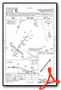
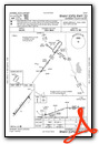
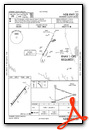
Nearby Airports with Instrument Procedures
| ID | Name | Heading / Distance | ||
|---|---|---|---|---|
 |
KLUX | Laurens County Airport | 308° | 19.3 |
|
35A | Union County, Troy Shelton Field Airport | 359° | 22.6 |
|
6J4 | Saluda County Airport | 198° | 24.2 |
|
KGRD | Greenwood County Airport | 262° | 26.0 |
|
KFDW | Fairfield County Airport | 089° | 26.4 |
|
KCAE | Columbia Metro Airport | 130° | 34.2 |
|
KDCM | Chester Catawba Regional Airport | 037° | 36.2 |
|
6J0 | Lexington County Airport | 147° | 36.6 |
|
KCUB | Jim Hamilton L B Owens Airport | 122° | 38.0 |
|
KSPA | Spartanburg Downtown Memorial/Simpson Field Airport | 336° | 39.6 |
|
KAIK | Aiken Regional Airport | 183° | 39.6 |
|
KGYH | Donaldson Field Airport | 306° | 45.3 |
Airport Images
Do you have a recent image of this airport? Upload it here!


