Login
Register


ESC
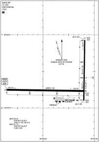
Delta County Airport
Official FAA Data Effective 2024-04-18 0901Z
Chart Supplement

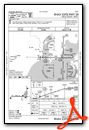
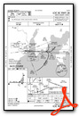
KESC Airport Diagram
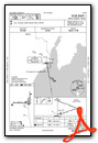
VFR Chart of KESC
Sectional Charts at SkyVector.com
IFR Chart of KESC
Enroute Charts at SkyVector.com
Location Information for KESC
Coordinates: N45°43.36' / W87°5.62'Located 02 miles SW of Escanaba, Michigan on 944 acres of land. View all Airports in Michigan.
Surveyed Elevation is 609 feet MSL.
Operations Data
|
|
Airport Communications
| AWOS-3PT: | 121.425 Tel. 906-786-9001 |
|---|---|
| UNICOM: | 122.800 |
| CTAF: | 122.800 |
| AWOS-3PT at 2P2 (21.4 S): | 118.525 920 847 3024 |
| AWOS-3PT at 3D2 (35.5 S): | 124.175 920-854-5559 |
| AWOS-3PT at SAW (39.2 N): | 118.375 906-346-5126 |
- APCH/DEP SVC PRVDD BY MINNEAPOLIS ARTCC ON FREQ 127.65 (ESCANABA RCAG).
Nearby Navigation Aids
|
| ||||||||||||||||||||||||||||||||||||||||||||||||||||||


Runway 10/28
| Dimensions: | 6498 x 150 feet / 1981 x 46 meters | |
|---|---|---|
| Surface: | Asphalt / Porous Friction Course in Good Condition | |
| Weight Limits: | 80 /F/A/X/T, S-80, D-120, ST-210 | |
| Edge Lighting: | High Intensity | |
| Runway 10 | Runway 28 | |
| Coordinates: | N45°43.25' / W87°6.72' | N45°43.23' / W87°5.19' |
| Elevation: | 609.1 | 593.1 |
| Traffic Pattern: | Left | Left |
| Runway Heading: | 91° True | 271° True |
| Declared Distances: | TORA:6498 TODA:6498 ASDA:6498 LDA:6498 | TORA:6498 TODA:6498 ASDA:6498 LDA:6498 |
| Markings: | Precision Instrument in good condition. | Precision Instrument in good condition. |
| Glide Slope Indicator | P4R (3.00° Glide Path Angle) | |
| Approach Lights: | MALSR 1,400 Foot Medium-intensity Approach Lighting System with runway alignment indicator lights. | |
| REIL: | Yes | |
Runway 01/19
| Dimensions: | 5016 x 100 feet / 1529 x 30 meters | |
|---|---|---|
| Surface: | Asphalt / Porous Friction Course in Good Condition | |
| Weight Limits: | 79 /F/A/X/T, S-40, D-60 | |
| Edge Lighting: | Medium Intensity | |
| Runway 01 | Runway 19 | |
| Coordinates: | N45°43.10' / W87°5.20' | N45°43.93' / W87°5.19' |
| Elevation: | 592.2 | 607.0 |
| Traffic Pattern: | Left | Left |
| Runway Heading: | 1° True | 181° True |
| Declared Distances: | TORA:5015 TODA:5015 ASDA:5015 LDA:5015 | TORA:5015 TODA:5015 ASDA:5015 LDA:5015 |
| Markings: | Non-Precision Instrument in good condition. | Non-Precision Instrument in good condition. |
| Glide Slope Indicator | P4L (3.00° Glide Path Angle) | P4L (3.00° Glide Path Angle) |
| REIL: | Yes | |
| Obstacles: | 51 ft Tree 1871 ft from runway, 61 ft right of center | |
Services Available
| Fuel: | 100LL (blue), Jet-A |
|---|---|
| Transient Storage: | Hangars |
| Airframe Repair: | MAJOR |
| Engine Repair: | MAJOR |
| Bottled Oxygen: | HIGH/LOW |
| Bulk Oxygen: | NONE |
| Other Services: | PILOT INSTRUCTION,AIRCRAFT RENTAL |
Ownership Information
| Ownership: | Publicly owned | |
|---|---|---|
| Owner: | DELTA COUNTY | |
| 310 LUDINGTON ST | ||
| ESCANABA, MI 49829-4057 | ||
| 906-789-5100 | ||
| Manager: | ROBERT RANSTADLER | |
| DELTA COUNTY AIRPORT, 3300 AIRPORT RD | ||
| ESCANABA, MI 49829-1057 | ||
| 906-217-7593 | ||
Operational Statistics
| Single Engine Aircraft Based on Field: | none | Statistics collected for 12 month period ending 2022-12-31 | |
|---|---|---|---|
| Multi-Engine Aircraft Based on Field: | none | Annual Commercial Operations: | 1260 |
| Jet Aircraft Based on Field: | none | Annual Commuter Operations: | none |
| Helicopters Based on Field: | none | Annual Air Taxi Operations: | 7000 |
| Military Aircraft Based on Field: | none | Annual Military Operations: | 100 |
| Gliders Based on Field: | none | Annual GA Local Operations: | 10000 |
| Ultralights Based on Field: | 1 | Annual GA Itinerant Operations: | 8000 |
Other Remarks
- FLD CONDS UNMON 2130-0600.
- FOR CD IF UNA TO CTC ON FSS FREQ, CTC MINNEAPOLIS ARTCC AT 651-463-5588.
- BIRDS ON & INVOF ARPT.
- 0LL 100LL AVBL H24 SELF SVC.
- ACTVT MALSR RWY 10; REIL RWY 01 & 28; PAPI RWY 28, 01, & 19; HIRL RWY 10/28; MIRL RWY 01/19 - CTAF.
Weather Minimums
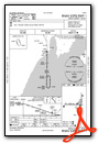
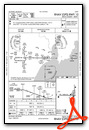
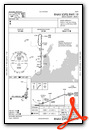
Instrument Approach Procedure (IAP) Charts
Nearby Airports with Instrument Procedures
| ID | Name | Heading / Distance | ||
|---|---|---|---|---|
 |
2P2 | Washington Island Airport | 160° | 21.3 |
|
3D2 | Ephraim/Gibraltar Airport | 186° | 35.4 |
|
KSAW | Marquette/Sawyer Regional Airport | 341° | 39.7 |
|
KISQ | Schoolcraft County Airport | 068° | 41.5 |
|
KMNM | Menominee Regional Airport | 212° | 42.5 |
|
KIMT | Ford Airport | 277° | 43.3 |
|
KSUE | Door County Cherryland Airport | 194° | 54.5 |
|
KOCQ | Oconto/J Douglas Bake Municipal Airport | 214° | 61.5 |
|
KSJX | Beaver Island Airport | 091° | 64.2 |
|
KFKS | Frankfort Dow Memorial Field Airport | 149° | 76.0 |
|
KERY | Luce County Airport | 062° | 77.0 |
|
Y55 | Crandon/Steve Conway Municipal Airport | 261° | 78.2 |
Airport Images
Do you have a recent image of this airport? Upload it here!


