Login
Register


EUF
Weedon Field Airport
Official FAA Data Effective 2024-04-18 0901Z
Chart Supplement

VFR Chart of KEUF
Sectional Charts at SkyVector.com
IFR Chart of KEUF
Enroute Charts at SkyVector.com
Location Information for KEUF
Coordinates: N31°57.08' / W85°7.74'Located 03 miles N of Eufaula, Alabama on 208 acres of land. View all Airports in Alabama.
Surveyed Elevation is 285 feet MSL.
Operations Data
|
|
Airport Communications
| ASOS: | 128.325 Tel. 334-687-5596 |
|---|---|
| ATLANTA APPROACH: | 125.5 126.55 ;7000 FT & ABV 323.1 ;BLW 7000 FT 353.75 ;7000 FT & ABV |
| ATLANTA DEPARTURE: | 125.5 126.55 ;7000 FT & ABV 323.1 ;BLW 7000 FT 353.75 ;7000 FT & ABV |
| CLEARANCE DELIVERY: | 134.25 339.8 |
| UNICOM: | 122.800 |
| CTAF: | 122.800 |
| ATIS at LSF (24.0 N): | 134.375 |
| ASOS at CSG (35.2 N): | 706-576-4715 |
| ATIS at CSG (35.3 N): | 127.75 |
- APCH/DEP SVC PRVDD BY ATLANTA LARGE TRACON 125.5 (0515-2200) OTHER TIMES ATLANTA ARTCC 120.45/298.850 (COLUMBUS RCAG)
- CLNC DEL PRVDD BY ATLANTA LARGE TRACON 134.25 (0515-2200) OTHER TIMES ATLANTA ARTCC 120.45/298.850 (COLUMBUS RCAG).
Nearby Navigation Aids
|
| ||||||||||||||||||||||||||||||||||||||||||||||||||||||||||||


Runway 18/36
| Dimensions: | 5000 x 100 feet / 1524 x 30 meters | |
|---|---|---|
| Surface: | Asphalt in Good Condition | |
| Weight Limits: | 11 /F/A/X/T | |
| Edge Lighting: | Medium Intensity | |
| Runway 18 | Runway 36 | |
| Coordinates: | N31°57.49' / W85°7.71' | N31°56.67' / W85°7.77' |
| Elevation: | 283.0 | 277.4 |
| Traffic Pattern: | Left | Left |
| Runway Heading: | 184° True | 4° True |
| Markings: | Non-Precision Instrument in good condition. | Non-Precision Instrument in good condition. |
| Glide Slope Indicator | P4L (3.00° Glide Path Angle) | P4L (3.00° Glide Path Angle) |
| Obstacles: | 42 ft Trees 669 ft from runway, 19 ft right of center | 24 ft Trees 374 ft from runway, 175 ft right of center |
Services Available
| Fuel: | 100LL (blue), Jet A+ |
|---|---|
| Transient Storage: | Hangars,Tiedowns |
| Airframe Repair: | NONE |
| Engine Repair: | NONE |
| Bottled Oxygen: | NONE |
| Bulk Oxygen: | NONE |
| Other Services: | PILOT INSTRUCTION,AIRCRAFT RENTAL |
Ownership Information
| Ownership: | Publicly owned | |
|---|---|---|
| Owner: | CITY OF EUFAULA | |
| BOX 219 | ||
| EUFAULA, AL 36027 | ||
| 334-688-2000 | ||
| Manager: | NIKKI OGLETREE | |
| 1730 N. EUFALA AVE | ||
| EUFAULA, AL 36027 | ||
| 334-695-0285 | 334-695-0285 AFT HRS. | |
Operational Statistics
| Single Engine Aircraft Based on Field: | 11 | Statistics collected for 12 month period ending 2020-02-11 | |
|---|---|---|---|
| Multi-Engine Aircraft Based on Field: | 1 | Annual Commercial Operations: | none |
| Jet Aircraft Based on Field: | none | Annual Commuter Operations: | none |
| Helicopters Based on Field: | none | Annual Air Taxi Operations: | none |
| Military Aircraft Based on Field: | none | Annual Military Operations: | 9500 |
| Gliders Based on Field: | none | Annual GA Local Operations: | 9047 |
| Ultralights Based on Field: | none | Annual GA Itinerant Operations: | 18091 |
Other Remarks
- LOW FLYING HELICOPTERS IN TFC PAT.
- ARPT LCTD IN WILDLIFE REFUGE - CONSTANT BIRD HAZARD.
- DUSK-2200. AFTER 2200, ACTVT PAPI RWYS 18 & 36; MIRL RWY 18/36 - CTAF.
Weather Minimums

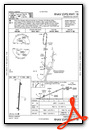
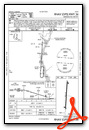
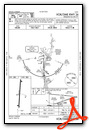
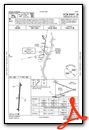
Instrument Approach Procedure (IAP) Charts
Nearby Airports with Instrument Procedures
| ID | Name | Heading / Distance | ||
|---|---|---|---|---|
 |
11A | Clayton Municipal Airport | 257° | 18.6 |
|
KLSF | Lawson AAF (Fort Moore) Airport | 017° | 23.9 |
|
KCSG | Columbus Airport | 015° | 35.2 |
|
KBIJ | Early County Airport | 160° | 35.3 |
|
KHDL | Headland Municipal Airport | 195° | 36.4 |
|
71J | Ozark/Blackwell Field Airport | 219° | 40.0 |
|
KDHN | Dothan Regional Airport | 203° | 41.2 |
|
06A | Moton Field Municipal Airport | 317° | 41.4 |
|
KAUO | Auburn University Regional Airport | 338° | 42.7 |
|
KTOI | Troy Municipal At N Kenneth Campbell Field Airport | 263° | 45.5 |
|
KACJ | Jimmy Carter Regional Airport | 078° | 48.9 |
|
KOZR | Cairns AAF (Fort Novosel) Airport | 216° | 50.3 |
Airport Images
Do you have a recent image of this airport? Upload it here!


