Login
Register


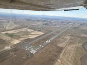
EUG
Mahlon Sweet Field Airport
Official FAA Data Effective 2024-04-18 0901Z
Chart Supplement

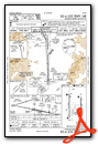
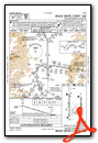
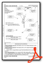
KEUG Airport Diagram

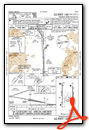
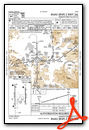
VFR Chart of KEUG
Sectional Charts at SkyVector.com
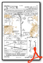
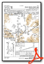
IFR Chart of KEUG
Enroute Charts at SkyVector.com
Location Information for KEUG
Coordinates: N44°7.47' / W123°12.72'Located 07 miles NW of Eugene, Oregon on 2600 acres of land. View all Airports in Oregon.
Surveyed Elevation is 373 feet MSL.
Operations Data
|
|
Airport Communications
| ATIS: | 125.225 (541-607-4699) |
|---|---|
| ASOS: | Tel. 541-461-3114 |
| EUGENE TOWER: | 118.9 ;RWY 16R/34L 124.15 ;RWY 16L/34R 371.9 |
| EUGENE GROUND: | 121.7 269.5 |
| CASCADE APPROACH: | 119.6 ;340-159 120.25 ;160-339 298.9 ;160-339 348.7 ;340-159 |
| CASCADE DEPARTURE: | 119.6 ;340-159 120.25 ;160-339 298.9 ;160-339 348.7 ;340-159 |
| IC: | 119.6 ;340-159 348.7 ;340-159 |
| CLEARANCE DELIVERY: | 121.7 269.5 |
| UNICOM: | 122.950 |
| CTAF: | 118.900 |
| EMERG: | 121.5 243.0 |
| AWOS-3 at 77S (14.6 SE): | 119.275 541 895 2349 |
| AWOS-3PT at CVO (22.9 N): | 135.775 541-754-0081 |
| AWOS-3PT at S12 (31.6 N): | 119.925 541-967-3508 |
- APCH/DEP CTL SVC PRVDD BY SEATTLE ARTCC (ZSE) ON FREQS 125.8/291.7 (HORTON RCAG) WHEN CASCADE APCH CTL (EUG) CLSD.
Nearby Navigation Aids
|
| ||||||||||||||||||||||||||||||||||||||||||||||||


Runway 16R/34L
| Dimensions: | 8009 x 150 feet / 2441 x 46 meters | |
|---|---|---|
| Surface: | Asphalt / Grooved in Good Condition | |
| Weight Limits: | 90 /F/C/X/T, S-120, D-250, ST-550 | |
| Edge Lighting: | High Intensity | |
| Runway 16R | Runway 34L | |
| Coordinates: | N44°8.13' / W123°13.15' | N44°6.81' / W123°13.13' |
| Elevation: | 360.2 | 365.5 |
| Traffic Pattern: | Left | Left |
| Runway Heading: | 179° True | 359° True |
| Declared Distances: | TORA:8009 TODA:8009 ASDA:8009 LDA:8009 | TORA:8009 TODA:8009 ASDA:8009 LDA:8009 |
| Markings: | Precision Instrument in good condition. | Precision Instrument in good condition. |
| Glide Slope Indicator | P4L (3.00° Glide Path Angle) | V4L (3.00° Glide Path Angle) |
| RVR Equipment | Touchdown Midfield Rollout | Touchdown Midfield Rollout |
| Approach Lights: | ALSF2 Standard 2,400 Foot High-intensity Approach Lighting System with sequenced flashers, CATEGORY II or III Configuration. | ODALS Omnidirectional Approach Lighting System |
| Centerline Lights: | Yes | Yes |
Runway 16L/34R
| Dimensions: | 6000 x 150 feet / 1829 x 46 meters | |
|---|---|---|
| Surface: | Asphalt / Grooved in Good Condition | |
| Weight Limits: | 60 /F/C/X/T, S-120, D-211, ST-342 | |
| Edge Lighting: | High Intensity | |
| Runway 16L | Runway 34R | |
| Coordinates: | N44°7.98' / W123°12.16' | N44°6.99' / W123°12.15' |
| Elevation: | 363.5 | 373.6 |
| Runway Heading: | 179° True | 359° True |
| Declared Distances: | TORA:6000 TODA:6000 ASDA:6000 LDA:6000 | TORA:6000 TODA:6000 ASDA:6000 LDA:6000 |
| Markings: | Precision Instrument in good condition. | Precision Instrument in good condition. |
| Glide Slope Indicator | P4L (3.00° Glide Path Angle) | P4L (3.00° Glide Path Angle) |
| Approach Lights: | MALSR 1,400 Foot Medium-intensity Approach Lighting System with runway alignment indicator lights. | |
| REIL: | Yes | |
Services Available
| Fuel: | 100LL (blue), Jet-A |
|---|---|
| Transient Storage: | Tiedowns |
| Airframe Repair: | MAJOR |
| Engine Repair: | MAJOR |
| Bottled Oxygen: | HIGH/LOW |
| Bulk Oxygen: | HIGH/LOW |
| Other Services: | AIR FREIGHT SERVICES,CROP DUSTING SERVICES,AIR AMBULANCE SERVICES,AVIONICS,CARGO HANDLING SERVICES,CHARTER SERVICE,PILOT INSTRUCTION,AIRCRAFT RENTAL,AIRCRAFT SALES |
Ownership Information
| Ownership: | Publicly owned | |
|---|---|---|
| Owner: | CITY OF EUGENE | |
| 125 E. 8TH | ||
| EUGENE, OR 97401 | ||
| (541) 682-5010 | ||
| Manager: | CATHRYN STEPHENS | |
| 28855 LOCKHEED DRIVE | ||
| EUGENE, OR 97402 | ||
| 541-682-5430 | ||
Operational Statistics
| Single Engine Aircraft Based on Field: | 88 | Statistics collected for 12 month period ending 2018-12-31 | |
|---|---|---|---|
| Multi-Engine Aircraft Based on Field: | 14 | Annual Commercial Operations: | 8658 |
| Jet Aircraft Based on Field: | 9 | Annual Commuter Operations: | none |
| Helicopters Based on Field: | 8 | Annual Air Taxi Operations: | 10125 |
| Military Aircraft Based on Field: | none | Annual Military Operations: | 7580 |
| Gliders Based on Field: | none | Annual GA Local Operations: | 15560 |
| Ultralights Based on Field: | none | Annual GA Itinerant Operations: | 22470 |
Other Remarks
- MIGRATORY WATERFOWL & OTR BIRDS ON & INVOF ARPT.
- TWYS H & K UNAVBL TO ACFT 21000 LBS SW & 40000 LBS DW GWT.
- TRML APRON CLSD TO ACFT EXCP SKEDD ACRS & FLTS WITH PRIOR PMSN.
- HELS LNDG AND DEPARTING AVOID OVERFLYING THE AIRLINE PSGR TRML AND RAMP LCTD E OF RY 16R/34L.
- NO ACES TO RWY 34L BYD TWY A6.
- FOR CD IF UNA TO CTC ON FSS FREQ, CTC SEATTLE ARTCC AT 253-351-3694.
- PAPI RYS 16R & 16L & 34R & VASI RY 34L OPER 24 HRS. WHEN ATCT CLSD HIRL RYS 16L/34R & 16R/34L PRE-SET MED INTST. WHEN ATCT CLSD ACTVT ALSF2 RY 16R, ODALS RY 34L, MALSR RY 16L & REIL RY 34R - CTAF.
Weather Minimums
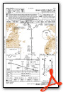
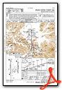
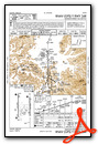
Instrument Approach Procedure (IAP) Charts
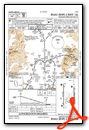
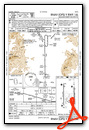
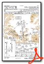
Departure Procedure (DP) Charts
Nearby Airports with Instrument Procedures
| ID | Name | Heading / Distance | ||
|---|---|---|---|---|
 |
77S | Hobby Field Airport | 142° | 14.6 |
|
KCVO | Corvallis Municipal Airport | 351° | 22.6 |
|
S12 | Albany Municipal Airport | 011° | 31.5 |
|
KONP | Newport Municipal Airport | 307° | 45.5 |
|
KSLE | Mcnary Field Airport | 010° | 47.9 |
|
KRBG | Roseburg Regional Airport | 186° | 53.5 |
|
KOTH | Southwest Oregon Regional Airport | 227° | 61.9 |
|
KMMV | Mc Minnville Municipal Airport | 002° | 64.3 |
|
KUAO | Aurora State Airport | 015° | 70.0 |
|
S21 | Sunriver Airport | 100° | 77.6 |
|
KTMK | Tillamook Airport | 341° | 81.8 |
|
KHIO | Portland-Hillsboro Airport | 007° | 85.8 |