Login
Register


EUL
Caldwell Exec Airport
Official FAA Data Effective 2024-04-18 0901Z
Chart Supplement

VFR Chart of KEUL
Sectional Charts at SkyVector.com
IFR Chart of KEUL
Enroute Charts at SkyVector.com
Location Information for KEUL
Coordinates: N43°38.51' / W116°38.15'Located 03 miles SE of Caldwell, Idaho on 154 acres of land. View all Airports in Idaho.
Surveyed Elevation is 2431 feet MSL.
Operations Data
|
|
Airport Communications
| AWOS-3PT: | 135.075 Tel. 208-454-3953 |
|---|---|
| BIG SKY APPROACH: | 119.6 269.4 |
| BIG SKY DEPARTURE: | 119.6 269.4 |
| UNICOM: | 123.000 |
| CTAF: | 123.000 |
| AWOS-3 at MAN (6.1 SE): | 118.325 208 318-0040 |
| D-ATIS at BOI (18.5 E): | 123.9 |
| ASOS at BOI (18.5 E): | 208-388-4640 |
Nearby Navigation Aids
|
| ||||||||||||||||||||||||

Runway 12/30
| Dimensions: | 5500 x 100 feet / 1676 x 30 meters | |
|---|---|---|
| Surface: | Asphalt in Excellent Condition | |
| Weight Limits: | S-72, D-86 | |
| Edge Lighting: | Medium Intensity | |
| Runway 12 | Runway 30 | |
| Coordinates: | N43°38.83' / W116°38.59' | N43°38.19' / W116°37.71' |
| Elevation: | 2425.9 | 2431.4 |
| Traffic Pattern: | Left | Right |
| Runway Heading: | 135° True | 315° True |
| Markings: | Non-Precision Instrument in good condition. | Non-Precision Instrument in good condition. |
| Glide Slope Indicator | P4L (3.00° Glide Path Angle) | P4L (3.00° Glide Path Angle) |
| Obstacles: | 12 ft Road 330 ft from runway, 260 ft left of center | |
Services Available
| Fuel: | 100LL (blue), Jet-A, Jet A+ |
|---|---|
| Transient Storage: | Tiedowns |
| Airframe Repair: | MAJOR |
| Engine Repair: | MAJOR |
| Bottled Oxygen: | NONE |
| Bulk Oxygen: | HIGH/LOW 208-459-2360. |
| Other Services: | AVIONICS,PILOT INSTRUCTION,PARACHUTE JUMP ACTIVITY,AIRCRAFT RENTAL,AIRCRAFT SALES |
Ownership Information
| Ownership: | Publicly owned | |
|---|---|---|
| Owner: | CITY OF CALDWELL | |
| PO BOX 1179 | ||
| CALDWELL, ID 83606 | ||
| 208-455-3000 | ||
| Manager: | ROB OATES | |
| 4814 E. LINDEN STREET | ||
| CALDWELL, ID 83605 | ||
| 208-459-9779 | ||
Operational Statistics
| Single Engine Aircraft Based on Field: | 473 | Statistics collected for 12 month period ending 2020-12-15 | |
|---|---|---|---|
| Multi-Engine Aircraft Based on Field: | 25 | Annual Commercial Operations: | none |
| Jet Aircraft Based on Field: | 6 | Annual Commuter Operations: | none |
| Helicopters Based on Field: | 26 | Annual Air Taxi Operations: | 2000 |
| Military Aircraft Based on Field: | none | Annual Military Operations: | 325 |
| Gliders Based on Field: | 2 | Annual GA Local Operations: | 110000 |
| Ultralights Based on Field: | 1 | Annual GA Itinerant Operations: | 35000 |
Other Remarks
- +363 FT RADIO TWR LCTD 1.4 MILES NORTH OF ARPT.
- FUEL AVBL 24 HRS BY CREDIT CARD. JET A FROM TRUCK MON-SAT 1500-2300Z++. CALL 208-453-8577 FOR JET A AND AFTER HOURS CALLOUT.
- RWY 12 CALM WIND RWY.
- PREFERRED PARKING FOR JET AND LARGE TURBOPROP ACFT AVBL ON TERMINAL APRON ON NORTH SIDE OF RWY.
- COURTESY CAR AVBL FOR TRAN AIRCREWS. CALL 208-459-9779 TO REQ COURTESY CAR.
- TRANSIENT RAMP PREFERRED FOR USE BY TRAINING HELICOPTERS FOR LAUNCH AND RECOVERY.
- PREFERRED HELICOPTER PAT SW OF RWY.
- FOR CD CTC BIG SKY APCH AT 208-364-5860/5861.
- ACTVT MIRL RY 12/30 - CTAF. PAPI RYS 12 & 30 OPER CONTINUOUSLY.
Weather Minimums
Instrument Approach Procedure (IAP) Charts

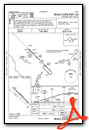
Nearby Airports with Instrument Procedures
| ID | Name | Heading / Distance | ||
|---|---|---|---|---|
 |
KMAN | Nampa Municipal Airport | 126° | 6.1 |
|
KBOI | Boise Air Trml/Gowen Field Airport | 104° | 18.6 |
|
KONO | Ontario Municipal Airport | 324° | 28.0 |
|
S87 | Weiser Municipal Airport | 337° | 36.6 |
|
KMUO | Mountain Home AFB Airport | 136° | 49.0 |
|
U76 | Mountain Home Municipal Airport | 127° | 50.1 |
|
KMYL | Mc Call Municipal Airport | 016° | 78.3 |
|
KBKE | Baker City Municipal Airport | 325° | 87.8 |
|
KGNG | Gooding Municipal Airport | 117° | 92.8 |
|
KBNO | Burns Municipal Airport | 269° | 101.1 |
|
KSUN | Friedman Memorial Airport | 093° | 102.4 |
|
10U | Owyhee Airport | 168° | 103.2 |
Airport Images
Do you have a recent image of this airport? Upload it here!


