Login
Register


F34
Firebaugh Airport
Official FAA Data Effective 2024-04-18 0901Z
Chart Supplement

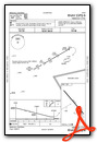
VFR Chart of F34
Sectional Charts at SkyVector.com
IFR Chart of F34
Enroute Charts at SkyVector.com
Location Information for F34
Coordinates: N36°51.60' / W120°27.87'Located 01 miles W of Firebaugh, California on 37 acres of land. View all Airports in California.
Surveyed Elevation is 157 feet MSL.
Operations Data
|
|
Airport Communications
| NORCAL APPROACH: | 120.95 269.45 |
|---|---|
| NORCAL DEPARTURE: | 120.95 269.45 |
| CTAF: | 122.900 |
| ASOS at MAE (18.5 NE): | 134.725 559-674-1781 |
| AWOS-3 at LSN (22.9 NW): | 118.675 209-827-7084 |
| ASOS at MCE (25.9 N): | 132.175 209-381-0926 |
- COMMUNICATIONS PRVDD BY FRESNO RADIO ON FREQ 122.1R (PANOCHE RCO).
Nearby Navigation Aids
|
| ||||||||||||||||||||||||||||||||||||||||||||||||


Runway 12/30
| Dimensions: | 3102 x 60 feet / 945 x 18 meters | |
|---|---|---|
| Surface: | Asphalt in Good Condition | |
| Weight Limits: | S-12 | |
| Edge Lighting: | Medium Intensity | |
| Runway 12 | Runway 30 | |
| Coordinates: | N36°51.79' / W120°28.07' | N36°51.40' / W120°27.66' |
| Elevation: | 156.9 | 157.0 |
| Traffic Pattern: | Right | Left |
| Runway Heading: | 140° True | 320° True |
| Markings: | Basic in fair condition. | Basic in fair condition. |
| Glide Slope Indicator | V2L (3.00° Glide Path Angle) | |
| Obstacles: | 10 ft Road 400 ft from runway RWY 12 +2' BERM, 6' FENCE & 5' DITCH 80'-140' FM RWY END 125'L TO 125'R. |
15 ft Road 700 ft from runway |
Services Available
| Fuel: | NONE |
|---|---|
| Transient Storage: | Tiedowns |
| Airframe Repair: | NONE |
| Engine Repair: | NONE |
| Bottled Oxygen: | NONE |
| Bulk Oxygen: | NONE |
| Other Services: | CROP DUSTING SERVICES |
Ownership Information
| Ownership: | Publicly owned | |
|---|---|---|
| Owner: | CITY OF FIREBAUGH | |
| 1133 P STREET | ||
| FIREBAUGH, CA 93622 | ||
| 559-659-2043 | ||
| Manager: | BEN GALLEGOS | CITY MGR. MAINTENANCE CONTACT PUBLIC WORKS, BEN GALLEGOS 559-659-2043 |
| 1133 P STREET | ||
| FIREBAUGH, CA 93622 | ||
| 559-659-2043 | ||
Operational Statistics
| Single Engine Aircraft Based on Field: | 7 | Statistics collected for 12 month period ending 2022-10-12 | |
|---|---|---|---|
| Multi-Engine Aircraft Based on Field: | 1 | Annual Commercial Operations: | none |
| Jet Aircraft Based on Field: | none | Annual Commuter Operations: | none |
| Helicopters Based on Field: | none | Annual Air Taxi Operations: | none |
| Military Aircraft Based on Field: | none | Annual Military Operations: | none |
| Gliders Based on Field: | none | Annual GA Local Operations: | 6000 |
| Ultralights Based on Field: | none | Annual GA Itinerant Operations: | 4000 |
Other Remarks
- FOR CD CTC NORCAL APCH AT 916-361-6874.
- RWY SAFETY AREA 140 FT BYD RWY 30 END.
- ACTVT MIRL RY 12/30 AND VASI RY 30 - CTAF.
Weather Minimums
Instrument Approach Procedure (IAP) Charts
Nearby Airports with Instrument Procedures
| ID | Name | Heading / Distance | ||
|---|---|---|---|---|
 |
KMAE | Madera Municipal Airport | 065° | 18.6 |
|
KLSN | Los Banos Municipal Airport | 302° | 23.0 |
|
KMCE | Merced Yosemite Regional Airport | 354° | 25.6 |
|
KMER | Castle Airport | 350° | 31.6 |
|
KFCH | Fresno Chandler Exec Airport | 103° | 32.0 |
|
KFAT | Fresno Yosemite International Airport | 097° | 36.3 |
|
C80 | New Coalinga Municipal Airport | 168° | 42.6 |
|
KMPI | Mariposa-Yosemite Airport | 027° | 44.0 |
|
KCVH | Hollister Municipal Airport | 272° | 45.6 |
|
O32 | Reedley Municipal Airport | 102° | 50.2 |
|
KMOD | Modesto City-County-Harry Sham Field Airport | 333° | 51.5 |
|
KHJO | Hanford Municipal Airport | 128° | 51.9 |
Airport Images
Do you have a recent image of this airport? Upload it here!


