Login
Register


FGX
Fleming-Mason Airport
Official FAA Data Effective 2024-04-18 0901Z
Chart Supplement

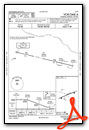
VFR Chart of KFGX
Sectional Charts at SkyVector.com
IFR Chart of KFGX
Enroute Charts at SkyVector.com
Location Information for KFGX
Coordinates: N38°32.50' / W83°44.64'Located 07 miles N of Flemingsburg, Kentucky on 77 acres of land. View all Airports in Kentucky.
Surveyed Elevation is 913 feet MSL.
Operations Data
|
|
Airport Communications
| AWOS-3: | 118.125 Tel. 606-742-2008 |
|---|---|
| CTAF: | 123.000 |
| UNICOM: | 123.000 |
| AWOS-3 at SYM (20.9 S): | 119.95 606-780-0279 |
| AWOS-3 at IOB (31.1 S): | 120.675 859-498-7001 |
| AWOS-3 at K62 (32.1 W): | 123.825 859-654-1345 |
- APCH/DEP SVC PRVDD BY INDIANAPOLIS ARTCC ON FREQS 124.225/360.725 (PORTSMOUTH RCAG).
Nearby Navigation Aids
|
| ||||||||||||||||||||||||||||||||||||||||||||||||||||||||||||


Runway 07/25
| Dimensions: | 5002 x 100 feet / 1525 x 30 meters | |
|---|---|---|
| Surface: | Asphalt in Good Condition | |
| Weight Limits: | 22 /F/C/X/T, S-58, D-79 | |
| Edge Lighting: | Medium Intensity | |
| Runway 07 | Runway 25 | |
| Coordinates: | N38°32.34' / W83°45.12' | N38°32.66' / W83°44.16' |
| Elevation: | 905.0 | 910.7 |
| Traffic Pattern: | Left | Left |
| Runway Heading: | 67° True | 247° True |
| Declared Distances: | TORA:5002 TODA:5002 ASDA:5002 LDA:4703 | TORA:5002 TODA:5002 ASDA:4703 LDA:4703 |
| Markings: | Non-Precision Instrument in poor condition. | Non-Precision Instrument in poor condition. |
| Glide Slope Indicator | P4R (3.00° Glide Path Angle) | P4L (3.00° Glide Path Angle) |
| REIL: | Yes | Yes |
| Obstacles: | 19 ft Tree 588 ft from runway, 197 ft left of center | 20 ft Tree 299 ft from runway, 153 ft left of center |
Services Available
| Fuel: | 100LL (blue), Jet A+ |
|---|---|
| Transient Storage: | Hangars,Tiedowns |
| Airframe Repair: | MINOR |
| Engine Repair: | MINOR |
| Bottled Oxygen: | NOT AVAILABLE |
| Bulk Oxygen: | NOT AVAILABLE |
| Other Services: | PILOT INSTRUCTION,AIRCRAFT RENTAL |
Ownership Information
| Ownership: | Publicly owned | |
|---|---|---|
| Owner: | FLEMING-MASON ARPT BOARD | DAVID MAHER |
| PO BOX 460,, POB 460 | ||
| MAYSVILLE, KY 41056 | ||
| (606) 407-2966 | ||
| Manager: | DERON MULLIKIN | |
| 7079 AIRPORT RD. | ||
| MAYSVILLE, KY 41056 | ||
| 606-742-2411 | MANAGER'S CELL (606) 541-2957 | |
Operational Statistics
| Single Engine Aircraft Based on Field: | 20 | Statistics collected for 12 month period ending 2022-06-24 | |
|---|---|---|---|
| Multi-Engine Aircraft Based on Field: | none | Annual Commercial Operations: | none |
| Jet Aircraft Based on Field: | none | Annual Commuter Operations: | none |
| Helicopters Based on Field: | 1 | Annual Air Taxi Operations: | none |
| Military Aircraft Based on Field: | none | Annual Military Operations: | 250 |
| Gliders Based on Field: | 1 | Annual GA Local Operations: | 6320 |
| Ultralights Based on Field: | none | Annual GA Itinerant Operations: | 10500 |
Other Remarks
- FOR CD CTC INDIANAPOLIS ARTCC AT 317-247-2411.
- MARKINGS FADED.
- MARKINGS FADED.
- ACTVT REIL RWY 07 & 25; PAPI RWY 07 & 25; MIRL RWY 07/25 - CTAF.
Weather Minimums
Instrument Approach Procedure (IAP) Charts
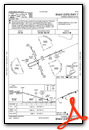
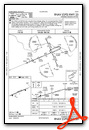
Nearby Airports with Instrument Procedures
| ID | Name | Heading / Distance | ||
|---|---|---|---|---|
 |
KAMT | Alexander Salamon Airport | 024° | 20.4 |
|
KSYM | Morehead-Rowan County Clyde A Thomas Regional Airport | 159° | 20.9 |
|
KGEO | Brown County Airport | 342° | 21.4 |
|
0I8 | Cynthiana-Harrison County Airport | 247° | 27.5 |
|
KIOB | Mount Sterling/Montgomery County Airport | 201° | 31.0 |
|
K62 | Gene Snyder Airport | 287° | 32.0 |
|
27K | Georgetown-Scott County Regional Airport | 240° | 37.4 |
|
I69 | Clermont County Airport | 325° | 38.9 |
|
KHOC | Highland County Airport | 013° | 40.0 |
|
KPMH | Greater Portsmouth Regional Airport | 066° | 45.8 |
|
KLUK | Cincinnati Municipal/Lunken Field Airport | 316° | 46.2 |
|
KDWU | Ashland Regional Airport | 088° | 47.4 |
Airport Images

By: Big Orange Bird


