Login
Register


FOZ
Bigfork Municipal Airport
Official FAA Data Effective 2024-04-18 0901Z
Chart Supplement

VFR Chart of KFOZ
Sectional Charts at SkyVector.com
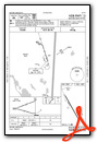
IFR Chart of KFOZ
Enroute Charts at SkyVector.com
Location Information for KFOZ
Coordinates: N47°47.04' / W93°39.06'Located 02 miles N of Bigfork, Minnesota on 160 acres of land. View all Airports in Minnesota.
Surveyed Elevation is 1351 feet MSL.
Operations Data
|
|
Airport Communications
| AWOS-3PT: | 118.025 Tel. 218-743-3289 |
|---|---|
| CTAF: | 122.900 |
| AWOS-3 at ORB (34.9 NE): | 118.325 218-757-3169 |
| AWOS-3PT at GPZ (35.4 S): | 118.425 218-326-8337 |
| AWOS-3 at CQM (38.8 E): | 118.175 218-666-2539 |
- APCH/DEP SVC PRVDD BY MINNEAPOLIS ARTCC ON FREQS 127.9/281.45(DULUTH RCAG).
Nearby Navigation Aids
|
| ||||||||||||||||||||||||||||||||||||||||||||||||||||||


Runway 15/33
| Dimensions: | 3998 x 75 feet / 1219 x 23 meters | |
|---|---|---|
| Surface: | Asphalt in Good Condition | |
| Edge Lighting: | Medium Intensity | |
| Runway 15 | Runway 33 | |
| Coordinates: | N47°47.32' / W93°39.30' | N47°46.75' / W93°38.82' |
| Elevation: | 1350.9 | 1345.9 |
| Traffic Pattern: | Left | Left |
| Runway Heading: | 151° True | 331° True |
| Markings: | Non-Precision Instrument in good condition. | Non-Precision Instrument in good condition. |
Services Available
| Fuel: | NONE |
|---|---|
| Transient Storage: | Tiedowns |
| Airframe Repair: | NONE |
| Engine Repair: | NONE |
| Bottled Oxygen: | NONE |
| Bulk Oxygen: | NONE |
Ownership Information
| Ownership: | Publicly owned | |
|---|---|---|
| Owner: | CITY OF BIGFORK | |
| PO BOX 196 | ||
| BIGFORK, MN 56628-0196 | ||
| 218-743-3782 | ||
| Manager: | KEVIN HOVILA | |
| PO BOX 196 | ||
| BIGFORK, MN 56628-0196 | ||
| 218-259-7443 | ||
Operational Statistics
| Single Engine Aircraft Based on Field: | 3 | Statistics collected for 12 month period ending 2017-08-31 | |
|---|---|---|---|
| Multi-Engine Aircraft Based on Field: | none | Annual Commercial Operations: | none |
| Jet Aircraft Based on Field: | none | Annual Commuter Operations: | none |
| Helicopters Based on Field: | none | Annual Air Taxi Operations: | none |
| Military Aircraft Based on Field: | none | Annual Military Operations: | none |
| Gliders Based on Field: | none | Annual GA Local Operations: | 2100 |
| Ultralights Based on Field: | none | Annual GA Itinerant Operations: | 1000 |
Other Remarks
- 350 FT TWR 2 NM SOUTH OF ARPT.
- DEER & WATERFOWL ON & INVOF ARPT.
- FOR CD CTC MINNEAPOLIS ARTCC AT 651-463-5588.
- ACTVT OR INCR INTST MIRL RWY 15/33 - CTAF. MIRL RWY 15/33 PRESET LOW INTST SS-SR.
Weather Minimums
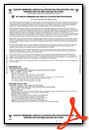
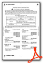
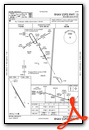
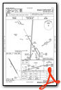
Instrument Approach Procedure (IAP) Charts
Nearby Airports with Instrument Procedures
| ID | Name | Heading / Distance | ||
|---|---|---|---|---|
 |
KORB | Orr Regional Airport | 066° | 35.0 |
|
KGPZ | Grand Rapids/Itasca County-Gordon Newstrom Field Airport | 170° | 35.0 |
|
KCQM | Cook Municipal Airport | 086° | 39.0 |
|
KHIB | Range Regional Airport | 125° | 40.7 |
|
KINL | Falls International/Einarson Field Airport | 011° | 48.0 |
|
KEVM | Eveleth/Virginia Municipal Airport | 114° | 51.6 |
|
KXVG | Longville Municipal Airport | 205° | 52.7 |
|
KBJI | Bemidji Regional Airport | 252° | 54.6 |
|
Y49 | Walker Municipal Airport | 227° | 55.2 |
|
12D | Tower Municipal Airport | 087° | 55.2 |
|
KBDE | Baudette International Airport | 326° | 68.6 |
|
KPWC | Pine River Regional Airport | 205° | 70.2 |
Airport Images
Do you have a recent image of this airport? Upload it here!


