Login
Register


FSM
Fort Smith Regional (Ebbing Field Angb) Airport
Official FAA Data Effective 2024-04-18 0901Z
From the Flight Deck
Chart Supplement

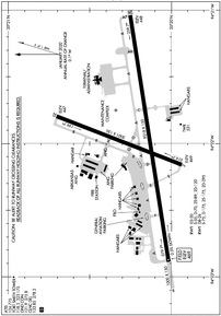
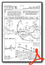
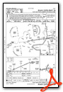
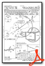
KFSM Airport Diagram
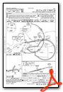
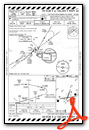
VFR Chart of KFSM
Sectional Charts at SkyVector.com
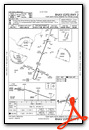
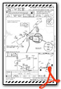
IFR Chart of KFSM
Enroute Charts at SkyVector.com
Location Information for KFSM
Coordinates: N35°20.20' / W94°21.97'Located 03 miles SE of Fort Smith, Arkansas on 1359 acres of land. View all Airports in Arkansas.
Surveyed Elevation is 469 feet MSL.
Operations Data
|
|
Airport Communications
| ATIS: | 124.775 |
|---|---|
| ASOS: | Tel. 479-649-2425 |
| FORT SMITH TOWER: | 118.3 323.175 |
| FORT SMITH GROUND: | 121.9 275.8 |
| RAZORBACK APPROACH: | 120.175 120.9 134.525 317.55 343.75 353.575 |
| RAZORBACK DEPARTURE: | 120.9 343.75 |
| CLEARANCE DELIVERY: | 133.85 278.3 |
| UNICOM: | 122.950 |
| CTAF: | 118.300 |
| TRSA: | 120.9 343.75 |
| EMERG: | 121.5 243.0 |
| AWOS-3 at JSV (22.2 W): | 118.475 918-775-4136 |
| AWOS-3 at RKR (22.8 SW): | 120.625 918-647-4063 |
| AWOS-3PT at GZL (35.8 W): | 118.575 918-967-8982 |
- TRSA SVC NOT PRVDD WITHIN R2401 AND R2402 WHEN ACTIVATED.
- TRSA SVC NOT PRVDD TO FORT CHAFFEE AAF FLIGHTS WITHIN THE FORT CHAFFEE TRAFFIC PATTERN.
- APCH/DEP SVC PRVDD BY MEMPHIS ARTCC ON FREQS 126.1/269.0 (FAYETTEVILLE RCAG) WHEN RAZORBACK APCH CTL CLSD.
Nearby Navigation Aids
|
| ||||||||||||||||||||||||||||||||||||||||||||||||||||||||||||


Runway 08/26
| Dimensions: | 9318 x 150 feet / 2840 x 46 meters | |
|---|---|---|
| Surface: | Asphalt / Grooved in Good Condition | |
| Weight Limits: | S-75, D-175, ST-295 | |
| Edge Lighting: | High Intensity | |
| Runway 08 | Runway 26 | |
| Coordinates: | N35°20.02' / W94°22.89' | N35°20.25' / W94°21.03' |
| Elevation: | 469.0 | 447.8 |
| Traffic Pattern: | Left | Left |
| Runway Heading: | 81° True | 261° True |
| Markings: | Precision Instrument in good condition. | Precision Instrument in good condition. |
| Glide Slope Indicator | P4R (3.00° Glide Path Angle) | P4L (3.00° Glide Path Angle) |
| RVR Equipment | Rollout | Touchdown |
| Approach Lights: | MALSR 1,400 Foot Medium-intensity Approach Lighting System with runway alignment indicator lights. | MALSR 1,400 Foot Medium-intensity Approach Lighting System with runway alignment indicator lights. |
| Obstacles: | 78 ft Tree 2102 ft from runway, 692 ft left of center | 100 ft Tree 3910 ft from runway, 1032 ft right of center |
Runway 02/20
| Dimensions: | 5001 x 150 feet / 1524 x 46 meters | |
|---|---|---|
| Surface: | Asphalt / Grooved in Good Condition | |
| Weight Limits: | S-55, D-70, ST-120 | |
| Edge Lighting: | Medium Intensity | |
| Runway 02 | Runway 20 | |
| Coordinates: | N35°19.94' / W94°22.16' | N35°20.70' / W94°21.79' |
| Elevation: | 448.8 | 447.4 |
| Traffic Pattern: | Left | Left |
| Runway Heading: | 21° True | 201° True |
| Declared Distances: | TORA:5001 TODA:5001 ASDA:5001 LDA:5001 | TORA:5001 TODA:5001 ASDA:5001 LDA:5001 |
| Markings: | Non-Precision Instrument in good condition. | Non-Precision Instrument in good condition. |
| Glide Slope Indicator | P4R (3.00° Glide Path Angle) PAPI UNUSBL BYD 8 DEGS LEFT OF CNTRLN. | P4L (3.00° Glide Path Angle) PAPI UNUSBL BYD 5 DEGS RIGHT OF CNTRLN. |
| Obstacles: | 21 ft Railroad 640 ft from runway, 313 ft right of center | 56 ft Tree 1495 ft from runway, 365 ft right of center |
Services Available
| Fuel: | 100LL (blue), Jet-A |
|---|---|
| Transient Storage: | Hangars,Tiedowns |
| Airframe Repair: | MAJOR |
| Engine Repair: | MAJOR |
| Bottled Oxygen: | NONE |
| Bulk Oxygen: | NONE |
| Other Services: | AIR FREIGHT SERVICES,AVIONICS,CHARTER SERVICE,PILOT INSTRUCTION |
Ownership Information
| Ownership: | Publicly owned | |
|---|---|---|
| Owner: | FORT SMITH ARPT COMMISSION | |
| 6700 MCKENNON BLVD SUITE 200 | ||
| FORT SMITH, AR 72903 | ||
| 479-452-7000 | ||
| Manager: | MICHAEL GRIFFIN | MICHAEL@FORTSMITHAIRPORT.COM |
| 6700 MC KENNON BLVD SUITE 200 | ||
| FORT SMITH, AR 72903 | ||
| 479-452-7000 | ||
Operational Statistics
| Single Engine Aircraft Based on Field: | 58 | Statistics collected for 12 month period ending 2021-06-30 | |
|---|---|---|---|
| Multi-Engine Aircraft Based on Field: | 12 | Annual Commercial Operations: | 1048 |
| Jet Aircraft Based on Field: | 5 | Annual Commuter Operations: | none |
| Helicopters Based on Field: | 1 | Annual Air Taxi Operations: | 2802 |
| Military Aircraft Based on Field: | none | Annual Military Operations: | 7894 |
| Gliders Based on Field: | 1 | Annual GA Local Operations: | 7095 |
| Ultralights Based on Field: | none | Annual GA Itinerant Operations: | 12978 |
Other Remarks
- RWY 02 AIMING POINTS 1390 FT FM THLD.
- FOR CD CTC MEMPHIS ARTCC AT 901-368-8453/8449.
- LNDG FEE FOR ALL FAR 121 & FAR 135 OPNS ABOVE 12,500 LBS.
- PPR FOR ALL ACFT (INCLUDING US GOVT) ABOVE 100,000 LBS. CTC AMGR 0800-1700 MON-FRI 479-452-7000; MINIMUM 24 HRS IN ADVANCE.
- FLOCK OF MIGRATORY BIRDS ON & INVOF ARPT.
- 0LL 100LL AVBL 24 HRS SELF SERVE. FOR JET A SAT & SUN 2200-0600, CALL 479-646-1611.
- WHEN ATCT CLSD ACTVT MALSR RWY 08 & 26; MIRL RWY 02/20; HIRL RWY 08/26 - CTAF.
Weather Minimums

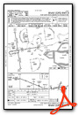
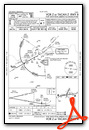
Instrument Approach Procedure (IAP) Charts
Nearby Airports with Instrument Procedures
| ID | Name | Heading / Distance | ||
|---|---|---|---|---|
 |
KJSV | Sallisaw Municipal Airport | 285° | 22.3 |
|
KRKR | Robert S Kerr Airport | 213° | 22.7 |
|
7M5 | Ozark/Franklin County Airport | 067° | 27.9 |
|
KGZL | Stigler Regional Airport | 265° | 35.9 |
|
KFYV | Drake Field Airport | 013° | 41.2 |
|
H35 | Clarksville Municipal Airport | 079° | 46.7 |
|
KTQH | Tahlequah Municipal Airport | 318° | 47.3 |
|
KMEZ | Mena Intermountain Municipal Airport | 170° | 48.1 |
|
32A | Danville Municipal Airport | 107° | 48.4 |
|
KSLG | Smith Field Airport | 353° | 51.6 |
|
KASG | Springdale Municipal Airport | 013° | 51.7 |
|
KMKO | Muskogee-Davis Regional Airport | 291° | 52.4 |
Airport Images
Do you have a recent image of this airport? Upload it here!


