Login
Register


FSO
Franklin County State Airport
Official FAA Data Effective 2024-04-18 0901Z
Chart Supplement

VFR Chart of KFSO
Sectional Charts at SkyVector.com
IFR Chart of KFSO
Enroute Charts at SkyVector.com
Location Information for KFSO
Coordinates: N44°56.42' / W73°5.85'Located 03 miles W of Highgate, Vermont on 348 acres of land. View all Airports in Vermont.
Surveyed Elevation is 227 feet MSL.
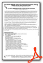
Operations Data
|
|
Airport Communications
| AWOS-3: | 119.025 Tel. 802-868-9941 |
|---|---|
| BURLINGTON APPROACH: | 121.1 278.8 ;EAST 360.8 ;WEST |
| BURLINGTON DEPARTURE: | 121.1 278.8 ;EAST 360.8 ;WEST |
| CTAF: | 122.800 |
| UNICOM: | 122.800 |
| ASOS at PBG (23.9 SW): | 132.225 518-324-5539 |
| ATIS at BTV (28.2 S): | 123.8 |
| ASOS at BTV (28.4 S): | 123.8 802-657-4490 |
- APCH/DEP SVC PRVDD BY BOSTON ARTCC ON FREQS 120.35/342.25 (ST. ALBANS RCAG) WHEN BURLINGTON APCH CTL CLSD.
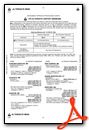
Nearby Navigation Aids
|
| ||||||||||||||||||||||||||||||||||||||||||||||||||||||||||||


Runway 01/19
| Dimensions: | 3001 x 60 feet / 915 x 18 meters | |
|---|---|---|
| Surface: | Asphalt in Good Condition | |
| Weight Limits: | S-12 | |
| Edge Lighting: | Medium Intensity | |
| Runway 01 | Runway 19 | |
| Coordinates: | N44°56.17' / W73°5.78' | N44°56.66' / W73°5.91' |
| Elevation: | 227.6 | 227.7 |
| Traffic Pattern: | Left | Left |
| Runway Heading: | 349° True | 169° True |
| Markings: | Non-Precision Instrument in good condition. | Non-Precision Instrument in good condition. |
| Glide Slope Indicator | P2L (4.00° Glide Path Angle) | |
| REIL: | Yes | Yes |
| Obstacles: | 93 ft Trees 1771 ft from runway, 250 ft left of center | 27 ft Trees 580 ft from runway, 27 ft right of center |
Services Available
| Fuel: | 100LL (blue), Jet A-1+ |
|---|---|
| Transient Storage: | Hangars,Tiedowns |
| Airframe Repair: | MAJOR |
| Engine Repair: | MAJOR |
| Bottled Oxygen: | NONE |
| Bulk Oxygen: | NONE |
| Other Services: | AVIONICS,PILOT INSTRUCTION,PARACHUTE JUMP ACTIVITY,AIRCRAFT RENTAL,AIRCRAFT SALES |
Ownership Information
| Ownership: | Publicly owned | |
|---|---|---|
| Owner: | STATE OF VERMONT | |
| 219 N MAIN ST | ||
| BARRE, VT 05641 | ||
| 802-279-2647 | ||
| Manager: | ROLLIN TEBBETTS | |
| 219 N MAIN ST | ||
| BARRE, VT 05641 | ||
| 802-585-5586 | ||
Operational Statistics
| Single Engine Aircraft Based on Field: | 57 | Statistics collected for 12 month period ending 2019-06-30 | |
|---|---|---|---|
| Multi-Engine Aircraft Based on Field: | 1 | Annual Commercial Operations: | none |
| Jet Aircraft Based on Field: | none | Annual Commuter Operations: | none |
| Helicopters Based on Field: | none | Annual Air Taxi Operations: | none |
| Military Aircraft Based on Field: | none | Annual Military Operations: | 400 |
| Gliders Based on Field: | none | Annual GA Local Operations: | 6000 |
| Ultralights Based on Field: | none | Annual GA Itinerant Operations: | 630 |
Other Remarks
- RWY CONDS MAY NOT BE MNT OR RPRTD WHEN ARPT IS UNATNDD.
- MIL EQPT MAY BE NEAR RWY.
- SEAGULLS INVOF ARPT.
- FOR CD CTC BURLINGTON APCH AT 802-657-4413, WHEN APCH CLSD CTC BOSTON ARTCC AT 603-879-6859.
- 0LL FUEL AVBL 24 HRS SELF-SERVE. AFT HRS SELF-SERVE FUEL KIOSK DOES NOT ACPT MASTERCARD.
- DUSK-DAWN. ACTVT REIL RWYS 01 & 19; PAPI RWY 01; MIRL RWY 01/19 - CTAF.
Weather Minimums
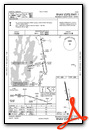
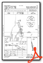
Instrument Approach Procedure (IAP) Charts
Nearby Airports with Instrument Procedures
| ID | Name | Heading / Distance | ||
|---|---|---|---|---|
 |
CYJN | St Jean Airport | 339° | 22.6 |
|
KPBG | Plattsburgh International Airport | 222° | 23.5 |
|
KBTV | Patrick Leahy Burlington International Airport | 184° | 28.2 |
|
KMVL | Morrisville-Stowe State Airport | 139° | 31.9 |
|
KEFK | Northeast Kingdom International Airport | 094° | 37.2 |
|
KMPV | Edward F Knapp State Airport | 152° | 49.8 |
|
KCDA | Caledonia County Airport | 115° | 51.2 |
|
KMAL | Malone-Dufort Airport | 264° | 52.8 |
|
KLKP | Lake Placid Airport | 222° | 54.9 |
|
KSLK | Adirondack Regional Airport | 235° | 58.0 |
|
4B6 | Ticonderoga Municipal Airport | 192° | 65.2 |
|
CYSC | Sherbrooke Airport | 062° | 66.7 |
Airport Images
Do you have a recent image of this airport? Upload it here!


