Login
Register


FTY
Fulton County Exec/Charlie Brown Field Airport
Official FAA Data Effective 2024-04-18 0901Z
Chart Supplement

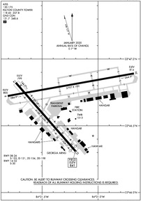
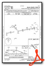
KFTY Airport Diagram
VFR Chart of KFTY
Sectional Charts at SkyVector.com
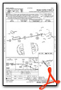
IFR Chart of KFTY
Enroute Charts at SkyVector.com
Location Information for KFTY
Coordinates: N33°46.75' / W84°31.28'Located 06 miles W of Atlanta, Georgia on 985 acres of land. View all Airports in Georgia.
Surveyed Elevation is 841 feet MSL.
Operations Data
|
|
Airport Communications
| ATIS: | 120.175 |
|---|---|
| ASOS: | Tel. 404-696-5660 |
| FULTON COUNTY TOWER: | 118.45 257.8 |
| FULTON COUNTY GROUND: | 121.7 348.6 |
| ATLANTA APPROACH: | 121.0 268.7 |
| ATLANTA DEPARTURE: | 121.0 268.7 |
| WRGNZ STAR: | 128.575 343.675 |
| OPS: | 141.35 |
| BOKRT STAR: | 119.8 354.125 |
| UNICOM: | 122.950 |
| ATIS at MGE (8.1 N): | 269.5 |
| ASOS at ATL (9.7 SE): | 404-559-5166 |
| D-ATIS at ATL (9.7 SE): | 119.65 ;ARR |
- EMERG FREQ 121.5 NOT AVBL.
Nearby Navigation Aids
|
| ||||||||||||||||||||||||||||||||||||||||||||||||||||||||||||


Runway 08/26
| Dimensions: | 5797 x 100 feet / 1767 x 30 meters | |
|---|---|---|
| Surface: | Asphalt / Grooved in Good Condition | |
| Weight Limits: | S-105, D-121, ST-198 | |
| Edge Lighting: | High Intensity | |
| Runway 08 | Runway 26 | |
| Coordinates: | N33°46.72' / W84°31.81' | N33°46.89' / W84°30.68' |
| Elevation: | 799.9 | 814.1 |
| Traffic Pattern: | Left | Right |
| Runway Heading: | 80° True | 260° True |
| Markings: | Precision Instrument in good condition. | Precision Instrument in good condition. |
| Glide Slope Indicator | V4L (3.00° Glide Path Angle) | |
| Approach Lights: | MALSR 1,400 Foot Medium-intensity Approach Lighting System with runway alignment indicator lights. | |
| REIL: | Yes | |
| Obstacles: | 30 ft Trees 201 ft from runway, 300 ft right of center 20+ FT TREES AT THLD 300-500 FT R OUT TO 200 FT. |
|
Runway 14/32
| Dimensions: | 4158 x 100 feet / 1267 x 30 meters | |
|---|---|---|
| Surface: | Asphalt in Fair Condition | |
| Weight Limits: | S-30 | |
| Edge Lighting: | Medium Intensity | |
| Runway 14 | Runway 32 | |
| Coordinates: | N33°46.82' / W84°31.74' | N33°46.31' / W84°31.20' |
| Elevation: | 798.7 | 841.1 |
| Traffic Pattern: | Left | Left |
| Runway Heading: | 139° True | 319° True |
| Displaced Threshold: | 200 Feet | |
| Declared Distances: | TORA:4158 TODA:4158 ASDA:4158 LDA:4158 | TORA:4158 TODA:4158 |
| Markings: | Basic in fair condition. | Basic in fair condition. |
| Glide Slope Indicator | P2L (4.00° Glide Path Angle) | |
| REIL: | Yes | Yes |
| Obstacles: | 27 ft Trees 551 ft from runway, 84 ft right of center | 90 ft Trees 1550 ft from runway, 164 ft right of center THREE LGTD TOWERS ON CNTRLN 32 FT & 650 FT FROM THLD. RY 32 APCH RATIO 20:1 TO DSPLCD THLD. 87FT TREES 1740FT FROM DSPLCD THLD. |
Services Available
| Fuel: | 100LL (blue), Jet A+ |
|---|---|
| Transient Storage: | Hangars,Tiedowns |
| Airframe Repair: | MAJOR |
| Engine Repair: | MAJOR |
| Bottled Oxygen: | HIGH/LOW |
| Bulk Oxygen: | HIGH/LOW |
| Other Services: | AIR FREIGHT SERVICES,AIR AMBULANCE SERVICES,AVIONICS,CARGO HANDLING SERVICES,CHARTER SERVICE,PILOT INSTRUCTION,AIRCRAFT RENTAL |
Ownership Information
| Ownership: | Publicly owned | |
|---|---|---|
| Owner: | FULTON COUNTY | |
| COUNTY COURTHOUSE, 141 PRYOR ST. | ||
| ATLANTA, GA 30303 | ||
| 404-699-4200 | ||
| Manager: | JONATHAN GAUTHIER | |
| 3952 AVIATION CIRCLE NW | ||
| ATLANTA, GA 30336 | ||
| 404-613-4205 | ||
Operational Statistics
| Single Engine Aircraft Based on Field: | 30 | Statistics collected for 12 month period ending 2021-12-31 | |
|---|---|---|---|
| Multi-Engine Aircraft Based on Field: | 5 | Annual Commercial Operations: | none |
| Jet Aircraft Based on Field: | 41 | Annual Commuter Operations: | none |
| Helicopters Based on Field: | 3 | Annual Air Taxi Operations: | none |
| Military Aircraft Based on Field: | none | Annual Military Operations: | none |
| Gliders Based on Field: | none | Annual GA Local Operations: | 34209 |
| Ultralights Based on Field: | none | Annual GA Itinerant Operations: | 45240 |
Other Remarks
- FLOCKS OF BIRDS ON AND INVOF ARPT DURING DALGT HRS.
- NOISE SENSITIVE AREA ALL QUADRANTS; NO RUN UPS AUTHORIZED ON ANY RAMPS.
- DEER AND OTHER WILDLIFE ON & INVOF ARPT.
- 0LL FUEL SVC HILL AVN, C404-691-3330.
Weather Minimums

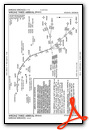
Standard Terminal Arrival (STAR) Charts
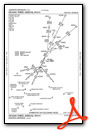
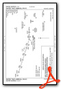
Instrument Approach Procedure (IAP) Charts


Nearby Airports with Instrument Procedures
| ID | Name | Heading / Distance | ||
|---|---|---|---|---|
 |
KMGE | Dobbins Arb Airport | 002° | 8.1 |
|
KATL | Hartsfield - Jackson Atlanta International Airport | 151° | 9.7 |
|
KPDK | Dekalb-Peachtree Airport | 062° | 12.4 |
|
KRYY | Cobb County International/Mccollum Field Airport | 344° | 14.5 |
|
KPUJ | Paulding Northwest Atlanta Airport | 290° | 22.4 |
|
KHMP | Atlanta Speedway Airport | 157° | 25.2 |
|
KFFC | Atlanta Regional Falcon Field Airport | 185° | 25.4 |
|
KVPC | Cartersville Airport | 321° | 26.3 |
|
KLZU | Gwinnett County/Briscoe Field Airport | 066° | 30.4 |
|
KCCO | Newnan Coweta County Airport | 204° | 30.6 |
|
KCNI | Cherokee County Regional Airport | 008° | 32.3 |
|
KCTJ | West Georgia Regional - O V Gray Field Airport | 254° | 32.8 |
Fuel Providers

Airport Images
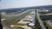
By: posi211


Comments
Procedure Printing
I have just noticed that when I select a procedure to print, it now downloads a pdf file that I now must open. this extra step is negatively impacting my use of your system as I print of many procedures every week.
Please advise.
Stephen Koch