Login
Register


FYV
Drake Field Airport
Official FAA Data Effective 2024-03-21 0901Z
Chart Supplement

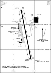
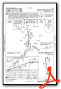
KFYV Airport Diagram
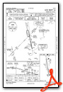
VFR Chart of KFYV
Sectional Charts at SkyVector.com
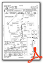
IFR Chart of KFYV
Enroute Charts at SkyVector.com
Location Information for KFYV
Coordinates: N36°0.30' / W94°10.20'Located 03 miles S of Fayetteville, Arkansas on 631 acres of land. View all Airports in Arkansas.
Surveyed Elevation is 1252 feet MSL.
Operations Data
|
|
Airport Communications
| ATIS: | 119.575 |
|---|---|
| ASOS: | 119.575 Tel. 479-442-5237 |
| DRAKE TOWER: | 128.0 371.9 |
| DRAKE GROUND: | 121.8 |
| RAZORBACK APPROACH: | 121.0 244.575 |
| RAZORBACK DEPARTURE: | 121.0 244.575 |
| UNICOM: | 122.950 |
| CTAF: | 128.000 |
| AWOS-3 at ASG (10.6 N): | 124.675 479-750-2967 |
| ASOS at XNA (17.9 N): | 119.425 479-203-0109 |
| ATIS at XNA (17.9 N): | 119.425 |
- APCH/DEP SVC PRVDD BY MEMPHIS ARTCC ON FREQS 126.1/269.0 (FAYETTEVILLE RCAG) WHEN RAZORBACK APCH CTL CLSD.
Nearby Navigation Aids
|
| ||||||||||||||||||||||||||||||||||||||||||||||||||||||||||||


Runway 16/34
| Dimensions: | 6005 x 100 feet / 1830 x 30 meters | |
|---|---|---|
| Surface: | Asphalt / Grooved in Good Condition | |
| Weight Limits: | S-90, D-150, ST-175 | |
| Edge Lighting: | Medium Intensity | |
| Runway 16 | Runway 34 | |
| Coordinates: | N36°0.79' / W94°10.32' | N35°59.82' / W94°10.09' |
| Elevation: | 1250.8 | 1237.9 |
| Traffic Pattern: | Left | Left |
| Runway Heading: | 169° True | 349° True |
| Declared Distances: | TORA:6005 TODA:6005 ASDA:6005 LDA:6005 | TORA:6005 TODA:6005 ASDA:6005 LDA:6005 |
| Markings: | Precision Instrument in good condition. | Precision Instrument in good condition. |
| Glide Slope Indicator | P4L (3.00° Glide Path Angle) | P4L (3.50° Glide Path Angle) |
| Approach Lights: | ODALS Omnidirectional Approach Lighting System | ODALS Omnidirectional Approach Lighting System |
| Obstacles: | 263 ft Tree 5585 ft from runway, 958 ft right of center | |
Services Available
| Fuel: | 100LL (blue), Jet-A |
|---|---|
| Transient Storage: | Hangars,Tiedowns |
| Airframe Repair: | MINOR |
| Engine Repair: | MINOR |
| Bottled Oxygen: | NOT AVAILABLE |
| Bulk Oxygen: | NONE |
| Other Services: | AIR FREIGHT SERVICES,AVIONICS,CARGO HANDLING SERVICES,CHARTER SERVICE,PILOT INSTRUCTION |
Ownership Information
| Ownership: | Publicly owned | |
|---|---|---|
| Owner: | CITY OF FAYETTEVILLE | |
| 113 MOUNTAIN ST | ||
| FAYETTEVILLE, AR 72701 | ||
| 479-575-8330 | ||
| Manager: | JARED RABREN | DIRECTOR, AVIATION. |
| 4500 S SCHOOL SUITE F | ||
| FAYETTEVILLE, AR 72701 | ||
| (479) 718-7644 | ||
Operational Statistics
| Single Engine Aircraft Based on Field: | 88 | Statistics collected for 12 month period ending 2023-06-30 | |
|---|---|---|---|
| Multi-Engine Aircraft Based on Field: | 6 | Annual Commercial Operations: | 92 |
| Jet Aircraft Based on Field: | 17 | Annual Commuter Operations: | none |
| Helicopters Based on Field: | 2 | Annual Air Taxi Operations: | 1522 |
| Military Aircraft Based on Field: | none | Annual Military Operations: | 790 |
| Gliders Based on Field: | none | Annual GA Local Operations: | 8487 |
| Ultralights Based on Field: | none | Annual GA Itinerant Operations: | 15877 |
Other Remarks
- DEER ON & INVOF ARPT.
- FOR CD CTC MEMPHIS ARTCC AT 901-368-8453/8449.
- 0LL FOR FUEL AFTER HRS CALL 479-443-4343; FEE CHARGED. SELF SERVICE AVBL 24 HRS.
- WHEN ATCT CLSD MIRL RWY 16/34 PRESET MED INTST. ACTVT ODALS RWY 16 & 34; PAPI RWY 34 - CTAF.
Weather Minimums
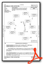
Instrument Approach Procedure (IAP) Charts
Departure Procedure (DP) Charts
Nearby Airports with Instrument Procedures
| ID | Name | Heading / Distance | ||
|---|---|---|---|---|
 |
KASG | Springdale Municipal Airport | 013° | 10.6 |
|
KXNA | Northwest Arkansas Ntl Airport | 338° | 17.9 |
|
KSLG | Smith Field Airport | 305° | 19.2 |
|
KVBT | Bentonville Municipal/Louise M Thaden Field Airport | 353° | 20.5 |
|
H34 | Huntsville Municipal Airport | 077° | 20.7 |
|
KROG | Rogers Exec - Carter Field Airport | 007° | 22.2 |
|
5M5 | Crystal Lake Airport | 326° | 24.3 |
|
7M5 | Ozark/Franklin County Airport | 151° | 33.7 |
|
4M1 | Carroll County Airport | 049° | 34.8 |
|
KTQH | Tahlequah Municipal Airport | 263° | 40.9 |
|
KFSM | Fort Smith Regional (Ebbing Field Angb) Airport | 193° | 41.2 |
|
94K | Cassville Municipal Airport | 017° | 43.5 |
Fuel Providers

Airport Images
Do you have a recent image of this airport? Upload it here!


