Login
Register


FZG
Fitzgerald Municipal Airport
Official FAA Data Effective 2024-04-18 0901Z
Chart Supplement

VFR Chart of KFZG
Sectional Charts at SkyVector.com
IFR Chart of KFZG
Enroute Charts at SkyVector.com
Location Information for KFZG
Coordinates: N31°41.03' / W83°16.25'Located 02 miles SW of Fitzgerald, Georgia on 271 acres of land. View all Airports in Georgia.
Surveyed Elevation is 364 feet MSL.
Operations Data
|
|
Airport Communications
| AWOS-3: | 118.625 Tel. 229-426-5072 |
|---|---|
| UNICOM: | 123.000 |
| CTAF: | 123.000 |
| AWOS-3PT at TMA (18.9 SW): | 118.525 229-386-8937 |
| AWOS-3 at DQH (24.4 SE): | 119.075 912-383-7258 |
| AWOS-3PT at CKF (31.5 NW): | 119.325 229-276-2669 |
- APCH/DEP SVC PRVDD BY JACKSONVILLE ARTCC ON FREQS 127.575/269.025 (ALMA RCAG).
Nearby Navigation Aids
|
| ||||||||||||||||||||||||||||||||||||||||||||||||||||||||||||


Runway 02/20
| Dimensions: | 5000 x 101 feet / 1524 x 31 meters | |
|---|---|---|
| Surface: | Asphalt in Good Condition | |
| Weight Limits: | D-28 | |
| Edge Lighting: | Medium Intensity | |
| Runway 02 | Runway 20 | |
| Coordinates: | N31°40.59' / W83°16.48' | N31°41.40' / W83°16.28' |
| Elevation: | 355.4 | 364.3 |
| Traffic Pattern: | Left | Left |
| Runway Heading: | 12° True | 192° True |
| Markings: | Non-Precision Instrument in good condition. | Non-Precision Instrument in good condition. |
| Glide Slope Indicator | P2L (3.00° Glide Path Angle) | P2L (3.00° Glide Path Angle) |
| Approach Lights: | ODALS Omnidirectional Approach Lighting System | |
| REIL: | Yes | |
| Obstacles: | 43 ft Trees 802 ft from runway, 325 ft right of center | 35 ft Trees 410 ft from runway, 266 ft right of center |
Runway 15/33
| Dimensions: | 2984 x 300 feet / 910 x 91 meters | |
|---|---|---|
| Surface: | Turf in Good Condition | |
| Runway 15 | Runway 33 | |
| Coordinates: | N31°41.29' / W83°16.23' | N31°40.91' / W83°15.86' |
| Elevation: | 362.1 | 338.5 |
| Traffic Pattern: | Left | Left |
| Runway Heading: | 141° True | 321° True |
| Obstacles: | 78 ft Trees 1014 ft from runway, 133 ft right of center | 60 ft Trees 360 ft from runway, 154 ft right of center |
Services Available
| Fuel: | 100LL (blue), Jet-A |
|---|---|
| Transient Storage: | Tiedowns |
| Airframe Repair: | MAJOR |
| Engine Repair: | MAJOR |
| Bottled Oxygen: | NONE |
| Bulk Oxygen: | NONE |
| Other Services: | PILOT INSTRUCTION |
Ownership Information
| Ownership: | Publicly owned | |
|---|---|---|
| Owner: | CITY OF FITZGERALD & BEN HILL | |
| 302 E CENTRAL AVE | ||
| FITZGERALD, GA 31750 | ||
| 229-426-5060 | ||
| Manager: | WILL HAMMOND | |
| BOX 963, 125 TERMINAL DRIVE | ||
| FITZGERALD, GA 31750 | ||
| 229-426-5071 | ||
Operational Statistics
| Single Engine Aircraft Based on Field: | 24 | Statistics collected for 12 month period ending 2023-12-31 | |
|---|---|---|---|
| Multi-Engine Aircraft Based on Field: | 7 | Annual Commercial Operations: | none |
| Jet Aircraft Based on Field: | 1 | Annual Commuter Operations: | none |
| Helicopters Based on Field: | 2 | Annual Air Taxi Operations: | none |
| Military Aircraft Based on Field: | none | Annual Military Operations: | none |
| Gliders Based on Field: | none | Annual GA Local Operations: | 2500 |
| Ultralights Based on Field: | none | Annual GA Itinerant Operations: | 2500 |
Other Remarks
- PAEW ADJ RWY 02/20.
- FOR CD CTC JACKSONVILLE ARTCC AT 904-845-1592.
- 15/33 THLDS MKD WITH WHITE TIRES.
- MIRL RWY 02/20 PRESET MED INTST DUSK-2200; AFT 2200 - CTAF. ACTVT ODALS RWY 02; REILS RWY 02; PAPI RWY 02 & 20 - CTAF.
Weather Minimums

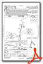
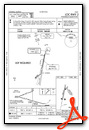
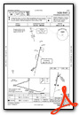
Instrument Approach Procedure (IAP) Charts
Nearby Airports with Instrument Procedures
| ID | Name | Heading / Distance | ||
|---|---|---|---|---|
 |
75J | Turner County Airport | 270° | 18.5 |
|
KTMA | Henry Tift Myers Airport | 216° | 18.9 |
|
KDQH | Douglas Municipal Airport | 120° | 24.4 |
|
4J2 | Berrien County Airport | 175° | 28.3 |
|
KCKF | Crisp County-Cordele Airport | 305° | 31.5 |
|
KMQW | Telfair-Wheeler Airport | 038° | 31.8 |
|
KEZM | Heart of Georgia Regional Airport | 012° | 32.7 |
|
KAZE | Hazlehurst Airport | 069° | 34.1 |
|
15J | Cook County Airport | 196° | 34.1 |
|
KAMG | Bacon County Airport | 102° | 40.2 |
|
48A | Cochran Airport | 359° | 42.9 |
|
KVAD | Moody AFB Airport | 174° | 43.0 |
Airport Images
Do you have a recent image of this airport? Upload it here!


