Login
Register


GAD
Northeast Alabama Regional Airport
Official FAA Data Effective 2024-04-18 0901Z
Chart Supplement

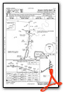
VFR Chart of KGAD
Sectional Charts at SkyVector.com
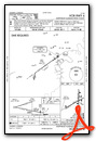
IFR Chart of KGAD
Enroute Charts at SkyVector.com
Location Information for KGAD
Coordinates: N33°58.36' / W86°5.35'Located 04 miles SW of Gadsden, Alabama on 1480 acres of land. View all Airports in Alabama.
Surveyed Elevation is 569 feet MSL.
Operations Data
|
|
Airport Communications
| AWOS-3PT: | 127.825 Tel. 256-442-7094 |
|---|---|
| BIRMINGHAM APPROACH: | 125.45 279.65 |
| BIRMINGHAM DEPARTURE: | 125.45 279.65 |
| CLEARANCE DELIVERY: | 120.05 257.7 |
| CTAF: | 122.800 |
| UNICOM: | 122.800 |
| AWOS-3PT at 8A0 (17.4 NW): | 119.575 256-891-8259 |
| AWOS-3PT at ASN (24.3 S): | 118.425 256-362-5847 |
| ASOS at ANB (25.8 SE): | 119.675 256-835-3931 |
Nearby Navigation Aids
|
| ||||||||||||||||||||||||||||||||||||||||||||||||||||||||||||


Runway 06/24
| Dimensions: | 6802 x 150 feet / 2073 x 46 meters | |
|---|---|---|
| Surface: | Asphalt / Grooved in Fair Condition | |
| Weight Limits: | S-90, D-115, ST-195 | |
| Edge Lighting: | High Intensity | |
| Runway 06 | Runway 24 | |
| Coordinates: | N33°57.95' / W86°6.06' | N33°58.50' / W86°4.89' |
| Elevation: | 569.2 | 549.3 |
| Traffic Pattern: | Left | Left |
| Runway Heading: | 61° True | 241° True |
| Markings: | Precision Instrument in fair condition. | Precision Instrument in fair condition. |
| Glide Slope Indicator | P4L (3.00° Glide Path Angle) | P4L (3.00° Glide Path Angle) |
| REIL: | Yes | Yes |
| Obstacles: | 52 ft Tree 1621 ft from runway, 222 ft right of center | 55 ft Tree 2724 ft from runway, 172 ft left of center |
Runway 18/36
| Dimensions: | 4806 x 100 feet / 1465 x 30 meters | |
|---|---|---|
| Surface: | Asphalt in Fair Condition | |
| Weight Limits: | S-25, D-40, ST-78 | |
| Edge Lighting: | Medium Intensity | |
| Runway 18 | Runway 36 | |
| Coordinates: | N33°58.95' / W86°5.16' | N33°58.15' / W86°5.16' |
| Elevation: | 541.9 | 553.0 |
| Traffic Pattern: | Left | Left |
| Runway Heading: | 180° True | 0 |
| Markings: | Non-Precision Instrument in fair condition. | Non-Precision Instrument in fair condition. |
| Glide Slope Indicator | P2L (2.75° Glide Path Angle) | P2L (2.75° Glide Path Angle) |
| Obstacles: | 27 ft Tree 677 ft from runway, 105 ft right of center | 67 ft Tree 1883 ft from runway, 127 ft right of center |
Services Available
| Fuel: | 100LL (blue), Jet A-1+ |
|---|---|
| Transient Storage: | Hangars,Tiedowns |
| Airframe Repair: | MAJOR |
| Engine Repair: | MAJOR |
| Bottled Oxygen: | NOT AVAILABLE |
| Bulk Oxygen: | NOT AVAILABLE |
| Other Services: | AVIONICS,CARGO HANDLING SERVICES,CHARTER SERVICE,PILOT INSTRUCTION,AIRCRAFT RENTAL |
Ownership Information
| Ownership: | Publicly owned | |
|---|---|---|
| Owner: | GADSDEN AIRPORT AUTHORITY | |
| 185 IRA GRAY DR. | ||
| GADSDEN, AL 35904 | ||
| 256-442-3313 | ||
| Manager: | ANTHONY TARVER | |
| 185 IRA GRAY DRIVE | ||
| GADSDEN, AL 35904 | ||
| 256-328-4700 | ||
Operational Statistics
| Single Engine Aircraft Based on Field: | 26 | Statistics collected for 12 month period ending 2020-07-31 | |
|---|---|---|---|
| Multi-Engine Aircraft Based on Field: | 6 | Annual Commercial Operations: | none |
| Jet Aircraft Based on Field: | 3 | Annual Commuter Operations: | none |
| Helicopters Based on Field: | 1 | Annual Air Taxi Operations: | 1200 |
| Military Aircraft Based on Field: | none | Annual Military Operations: | 430 |
| Gliders Based on Field: | none | Annual GA Local Operations: | 4736 |
| Ultralights Based on Field: | none | Annual GA Itinerant Operations: | 17520 |
Other Remarks
- MARKINGS FADED.
- MARKINGS FADED.
- ACTVT REIL RWYS 6 & 24; PAPI RWYS 6, 24, 18 & 36; HIRL RWY 6/24; MIRL RWY 18/36; TWY LGTS - CTAF.
Weather Minimums

Instrument Approach Procedure (IAP) Charts
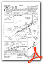

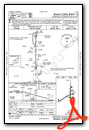
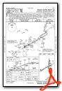
Nearby Airports with Instrument Procedures
| ID | Name | Heading / Distance | ||
|---|---|---|---|---|
 |
20A | Robbins Field Airport | 269° | 14.5 |
|
8A0 | Albertville Regional/Thomas J Brumlik Field Airport | 331° | 17.5 |
|
KASN | Talladega Municipal Airport | 175° | 24.2 |
|
KPYP | Centre-Piedmont-Cherokee County Regional Airport | 073° | 24.9 |
|
KANB | Anniston Regional Airport | 153° | 25.8 |
|
KPLR | St Clair County Airport | 197° | 26.0 |
|
8A1 | Guntersville Municipal/Joe Starnes Field Airport | 341° | 27.3 |
|
4A9 | Isbell Field Airport | 031° | 35.1 |
|
KBHM | Birmingham-Shuttlesworth International Airport | 233° | 41.2 |
|
KCMD | Cullman Regional/Folsom Field Airport | 295° | 42.2 |
|
4A6 | Scottsboro Municipal-Word Field Airport | 005° | 43.1 |
|
4A4 | Polk County/Cornelius Moore Field Airport | 086° | 47.2 |
Airport Images
Do you have a recent image of this airport? Upload it here!


