Login
Register


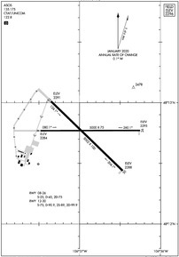
GGW
Wokal Field/Glasgow-Valley County Airport
Official FAA Data Effective 2024-04-18 0901Z
Chart Supplement

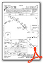
KGGW Airport Diagram
VFR Chart of KGGW
Sectional Charts at SkyVector.com
IFR Chart of KGGW
Enroute Charts at SkyVector.com
Location Information for KGGW
Coordinates: N48°12.75' / W106°36.89'Located 01 miles NE of Glasgow, Montana on 1552 acres of land. View all Airports in Montana.
Surveyed Elevation is 2295 feet MSL.
Operations Data
|
|
Airport Communications
| ASOS: | 135.175 Tel. 406-228-8294 |
|---|---|
| CTAF: | 122.800 |
| UNICOM: | 122.800 |
| ASOS at OLF (42.2 E): | 118.325 406-653-3865 |
| AWOS-3 at M75 (52.9 W): | 119.250 406 654 1279 |
| AWOS-3PT at PO1 (58.3 E): | 135.325 406-448-2453 |
- APCH/DEP CTL SVC PRVDD BY SALT LAKE ARTCC ( ZLC) ON FREQS 126.85/305.2 (GLASGOW RCAG).
Nearby Navigation Aids
|
| ||||||||||||||||||

Runway 12/30
| Dimensions: | 5002 x 100 feet / 1525 x 30 meters | |
|---|---|---|
| Surface: | Asphalt / Grooved in Good Condition | |
| Weight Limits: | S-75, D-90, ST-99 | |
| Edge Lighting: | Medium Intensity | |
| Runway 12 | Runway 30 | |
| Coordinates: | N48°13.01' / W106°37.35' | N48°12.44' / W106°36.46' |
| Elevation: | 2290.9 | 2287.7 |
| Traffic Pattern: | Left | Left |
| Runway Heading: | 134° True | 314° True |
| Declared Distances: | TORA:5001 TODA:5001 ASDA:5001 LDA:5001 | TORA:5001 TODA:5001 ASDA:5001 LDA:5001 |
| Markings: | Non-Precision Instrument in good condition. | Non-Precision Instrument in good condition. |
| Glide Slope Indicator | P4L (3.00° Glide Path Angle) | P4L (3.00° Glide Path Angle) |
| REIL: | Yes | Yes |
Runway 08/26
| Dimensions: | 5000 x 75 feet / 1524 x 23 meters | |
|---|---|---|
| Surface: | Asphalt / Grooved in Excellent Condition | |
| Weight Limits: | S-25, D-45, ST-75 | |
| Edge Lighting: | Medium Intensity | |
| Runway 08 | Runway 26 | |
| Coordinates: | N48°12.77' / W106°37.48' | N48°12.77' / W106°36.25' |
| Elevation: | 2284.2 | 2295.4 |
| Traffic Pattern: | Left | Left |
| Runway Heading: | 90° True | 270° True |
| Declared Distances: | TORA:5000 TODA:5000 ASDA:5000 LDA:5000 | TORA:5000 TODA:5000 ASDA:5000 LDA:5000 |
| Markings: | Basic in fair condition. | Basic in good condition. |
| Glide Slope Indicator | P2L (3.00° Glide Path Angle) | P2L (3.00° Glide Path Angle) |
| REIL: | Yes | Yes |
Services Available
| Fuel: | 100LL (blue), Jet A-1+ |
|---|---|
| Transient Storage: | Hangars,Tiedowns |
| Airframe Repair: | MAJOR |
| Engine Repair: | MAJOR |
| Bottled Oxygen: | HIGH/LOW |
| Bulk Oxygen: | HIGH/LOW |
| Other Services: | AIR FREIGHT SERVICES,CROP DUSTING SERVICES,AIR AMBULANCE SERVICES,CARGO HANDLING SERVICES,CHARTER SERVICE,PILOT INSTRUCTION,AIRCRAFT RENTAL,AIRCRAFT SALES |
Ownership Information
| Ownership: | Publicly owned | |
|---|---|---|
| Owner: | GLASGOW VALLEY CO | |
| 89 AIRPORT RD | ||
| GLASGOW, MT 59230 | ||
| 406-228-2719 | ||
| Manager: | LUCAS LOCKE | |
| 89 AIRPORT RD | ||
| GLASGOW, MT 59230 | ||
| (406) 228-2719 | ||
Operational Statistics
| Single Engine Aircraft Based on Field: | 44 | Statistics collected for 12 month period ending 2023-05-15 | |
|---|---|---|---|
| Multi-Engine Aircraft Based on Field: | none | Annual Commercial Operations: | none |
| Jet Aircraft Based on Field: | none | Annual Commuter Operations: | none |
| Helicopters Based on Field: | 1 | Annual Air Taxi Operations: | 3460 |
| Military Aircraft Based on Field: | none | Annual Military Operations: | 20 |
| Gliders Based on Field: | none | Annual GA Local Operations: | 3500 |
| Ultralights Based on Field: | none | Annual GA Itinerant Operations: | 1250 |
Other Remarks
- FOR CD IF UNA TO CTC ON FSS FREQ, CTC SALT LAKE ARTCC AT 801-320-2568.
- ACTVT MIRL RYS 08/26 & 12/30, REIL RYS 8,12,26, & 30 - CTAF. PAPI RYS 08, 12, 26, & 30, OPER 24 HRS.
Weather Minimums
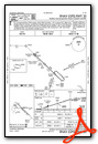
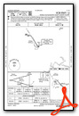
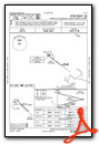
Instrument Approach Procedure (IAP) Charts
Nearby Airports with Instrument Procedures
| ID | Name | Heading / Distance | ||
|---|---|---|---|---|
 |
KOLF | L M Clayton Airport | 099° | 42.4 |
|
M75 | Malta Airport | 280° | 53.1 |
|
PO1 | Poplar Municipal Airport | 094° | 58.5 |
|
9S2 | Scobey Airport | 052° | 59.0 |
|
4U6 | Circle Town County Airport | 137° | 63.9 |
|
KPWD | Sher-Wood Airport | 066° | 90.4 |
|
KGDV | Dawson Community Airport | 130° | 97.6 |
|
KSDY | Sidney-Richland Regional Airport | 106° | 102.3 |
|
KMLS | Frank Wiley Field Airport | 164° | 111.2 |
|
KXWA | Williston Basin International Airport | 087° | 114.9 |
|
1S3 | Tillitt Field Airport | 180° | 116.5 |
|
KRPX | Roundup Airport | 217° | 130.6 |
Airport Images
Do you have a recent image of this airport? Upload it here!


