Login
Register


GHM
Centerville Municipal Airport
Official FAA Data Effective 2024-04-18 0901Z
Chart Supplement

VFR Chart of KGHM
Sectional Charts at SkyVector.com
IFR Chart of KGHM
Enroute Charts at SkyVector.com
Location Information for KGHM
Coordinates: N35°50.24' / W87°26.72'Located 03 miles N of Centerville, Tennessee on 100 acres of land. View all Airports in Tennessee.
Surveyed Elevation is 765 feet MSL.
Operations Data
|
|
Airport Communications
| UNICOM: | 122.800 |
|---|---|
| CTAF: | 122.800 |
| AWOS-3 at M02 (17.5 N): | 123.875 615-446-5481 |
| AWOS-3 at MRC (21.3 SE): | 128.625 931-379-0844 |
| ATIS at JWN (34.2 NE): | 127.075 |
- APCH/DEP SVC PRVDD BY MEMPHIS ARTCC ON FREQS 125.85/379.25 (CENTERVILLE RCAG).
Nearby Navigation Aids
|
| ||||||||||||||||||||||||||||||||||||||||||||||||||||||||||||


Runway 02/20
| Dimensions: | 4002 x 75 feet / 1220 x 23 meters | |
|---|---|---|
| Surface: | Asphalt in Good Condition | |
| Weight Limits: | S-21, D-31 | |
| Edge Lighting: | Medium Intensity | |
| Runway 02 | Runway 20 | |
| Coordinates: | N35°49.93' / W87°26.85' | N35°50.56' / W87°26.60' |
| Elevation: | 765.0 | 765.0 |
| Traffic Pattern: | Left | Left |
| Runway Heading: | 18° True | 198° True |
| Displaced Threshold: | 250 Feet | |
| Markings: | Non-Precision Instrument in good condition. | Non-Precision Instrument in good condition. |
| Glide Slope Indicator | P4L (4.00° Glide Path Angle) | P4L (4.00° Glide Path Angle) PAPI UNUSBL BYD 5 DEGS LEFT OF CNTRLN. |
| REIL: | Yes | Yes |
| Obstacles: | 72 ft Trees 983 ft from runway, 980 ft right of center | 98 ft Tree 1519 ft from runway, 171 ft right of center |
Services Available
| Fuel: | 100LL (blue), Jet A+ |
|---|---|
| Transient Storage: | Hangars,Tiedowns |
| Airframe Repair: | NOT AVAILABLE |
| Engine Repair: | NOT AVAILABLE |
| Bottled Oxygen: | NOT AVAILABLE |
| Bulk Oxygen: | NOT AVAILABLE |
Ownership Information
| Ownership: | Publicly owned | |
|---|---|---|
| Owner: | TOWN OF CENTERVILLE | |
| 102 EAST SWAN | ||
| CENTERVILLE, TN 37033 | ||
| 931-729-4246 | ||
| Manager: | WOODY WOODRUFF | |
| 2650 AIRPORT RD | ||
| CENTERVILLE, TN 37033 | ||
| 931-729-3032 | ||
Operational Statistics
| Single Engine Aircraft Based on Field: | 14 | Statistics collected for 12 month period ending 2016-12-31 | |
|---|---|---|---|
| Multi-Engine Aircraft Based on Field: | 3 | Annual Commercial Operations: | none |
| Jet Aircraft Based on Field: | none | Annual Commuter Operations: | none |
| Helicopters Based on Field: | none | Annual Air Taxi Operations: | none |
| Military Aircraft Based on Field: | none | Annual Military Operations: | 200 |
| Gliders Based on Field: | none | Annual GA Local Operations: | 1912 |
| Ultralights Based on Field: | none | Annual GA Itinerant Operations: | 1000 |
Other Remarks
- FOR CD CTC MEMPHIS ARTCC AT 901-368-8453/8449.
- 0LL FUEL AVBL H24 WITH CREDIT CARD.
- MIRL RWY 02/20 OPR DUSK-DAWN & PRESET LOW INTST; INCR INTST & ACTVT - CTAF. 0730-1600 ACTVT VGSI RWY 02 - CTAF.
Weather Minimums
Instrument Approach Procedure (IAP) Charts
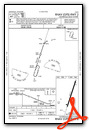
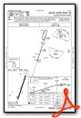
Nearby Airports with Instrument Procedures
| ID | Name | Heading / Distance | ||
|---|---|---|---|---|
 |
M02 | Dickson Municipal Airport | 002° | 17.4 |
|
0M3 | Paul Bridges Field Airport | 203° | 19.0 |
|
KMRC | Maury County Regional Airport | 142° | 21.4 |
|
0M5 | Humphreys County Airport | 319° | 22.0 |
|
KJWN | John C Tune Airport | 052° | 34.2 |
|
0M4 | Benton County Airport | 287° | 34.7 |
|
KLUG | Ellington Airport | 122° | 37.1 |
|
2M2 | Lawrenceburg-Lawrence County Airport | 165° | 37.3 |
|
KPVE | Beech River Regional Airport | 253° | 38.2 |
|
KBNA | Nashville International Airport | 065° | 41.1 |
|
KGZS | Abernathy Field Airport | 154° | 45.1 |
|
KMQY | Smyrna Airport | 076° | 46.2 |
Airport Images
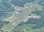
By: Big Orange Bird

By: Big Orange Bird


