Login
Register


GLE
Gainesville Municipal Airport
Official FAA Data Effective 2024-03-21 0901Z
Chart Supplement

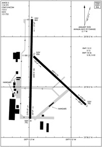
KGLE Airport Diagram
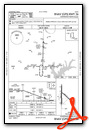
VFR Chart of KGLE
Sectional Charts at SkyVector.com
IFR Chart of KGLE
Enroute Charts at SkyVector.com
Location Information for KGLE
Coordinates: N33°39.13' / W97°11.84'Located 03 miles W of Gainesville, Texas on 1336 acres of land. View all Airports in Texas.
Surveyed Elevation is 845 feet MSL.
Operations Data
|
|
Airport Communications
| AWOS-3: | 118.375 Tel. 940-612-3549 |
|---|---|
| UNICOM: | 123.000 |
| CTAF: | 123.000 |
| ATIS at GYI (26.4 E): | 118.775 |
| AWOS-3 at GYI (26.4 E): | 118.775 903-786-7790 |
| ASOS at DTO (26.6 S): | 119.325 940-383-8457 |
- APCH/DEP CTL SVC PRVDD BY FORT WORTH ARTCC (ZFW) ON FREQS 124.75/323.0 (GAINESVILLE RCAG).
Nearby Navigation Aids
|
| ||||||||||||||||||||||||||||||||||||||||||||||||||||||||||||


Runway 18/36
| Dimensions: | 6000 x 100 feet / 1829 x 30 meters | |
|---|---|---|
| Surface: | Asphalt in Excellent Condition | |
| Weight Limits: | S-30, D-50 | |
| Edge Lighting: | Medium Intensity | |
| Runway 18 | Runway 36 | |
| Coordinates: | N33°39.67' / W97°11.97' | N33°38.69' / W97°11.99' |
| Elevation: | 845.4 | 792.4 |
| Traffic Pattern: | Left | Left |
| Runway Heading: | 181° True | 1° True |
| Markings: | Non-Precision Instrument in good condition. | Non-Precision Instrument in good condition. |
| Glide Slope Indicator | P2R (3.00° Glide Path Angle) | P2L (3.00° Glide Path Angle) |
| REIL: | Yes | Yes |
| Obstacles: | 52 ft Power Line 1968 ft from runway | |
Runway 13/31
| Dimensions: | 4307 x 75 feet / 1313 x 23 meters | |
|---|---|---|
| Surface: | Asphalt in Good Condition | |
| Weight Limits: | S-15 | |
| Runway 13 | Runway 31 | |
| Coordinates: | N33°39.31' / W97°11.95' | N33°38.82' / W97°11.32' |
| Elevation: | 826.3 | 792.2 |
| Traffic Pattern: | Left | Left |
| Runway Heading: | 133° True | 313° True |
| Markings: | Basic in poor condition. | Basic in poor condition. |
| Obstacles: | 59 ft Trees 1725 ft from runway, 275 ft right of center | |
Services Available
| Fuel: | 100LL (blue), Jet A+ |
|---|---|
| Transient Storage: | Hangars,Tiedowns |
| Airframe Repair: | MAJOR |
| Engine Repair: | MAJOR |
| Bottled Oxygen: | NOT AVAILABLE |
| Bulk Oxygen: | NONE |
| Other Services: | CROP DUSTING SERVICES,PILOT INSTRUCTION,AIRCRAFT RENTAL |
Ownership Information
| Ownership: | Publicly owned | |
|---|---|---|
| Owner: | CITY OF GAINESVILLE | |
| 200 S. RUSK | ||
| GAINESVILLE, TX 76240 | ||
| 940-668-4500 | ||
| Manager: | DAVID VINTON | |
| 2300 AIRPORT DR | ||
| GAINESVILLE, TX 76240 | ||
| 940-668-4565 | ||
Operational Statistics
| Single Engine Aircraft Based on Field: | 73 | Statistics collected for 12 month period ending 2022-09-16 | |
|---|---|---|---|
| Multi-Engine Aircraft Based on Field: | 10 | Annual Commercial Operations: | none |
| Jet Aircraft Based on Field: | 7 | Annual Commuter Operations: | none |
| Helicopters Based on Field: | 1 | Annual Air Taxi Operations: | none |
| Military Aircraft Based on Field: | none | Annual Military Operations: | 100 |
| Gliders Based on Field: | none | Annual GA Local Operations: | 12100 |
| Ultralights Based on Field: | none | Annual GA Itinerant Operations: | 12100 |
Other Remarks
- FOR CD CTC FORT WORTH ARTCC AT 817-858-7584.
- HEL SKID LDG PROHIBITED ON ALL PAVED SFCS.
- MARKINGS FADED
- RWY HAS AIM POINTS.
- MARKINGS FADED.
- RWY HAS AIM POINTS.
- 0LL 100LL SELF-SERVE & FULL SERVE.
- DUSK-DAWN. MIRL RWY 18/36 PRESET LOW INTST; TO INCR INTST ACTVT - CTAF. PAPI RWYS 18 & 36 OPR CONSLY.
Weather Minimums
Instrument Approach Procedure (IAP) Charts
Nearby Airports with Instrument Procedures
| ID | Name | Heading / Distance | ||
|---|---|---|---|---|
 |
KGYI | North Texas Regional/Perrin Field Airport | 081° | 26.4 |
|
KDTO | Denton Enterprise Airport | 180° | 27.0 |
|
0F2 | Bowie Municipal Airport | 264° | 29.1 |
|
1F0 | Ardmore Downtown Exec Airport | 007° | 29.9 |
|
KSWI | Sherman Municipal Airport | 092° | 30.7 |
|
KLUD | Decatur Municipal Airport | 219° | 30.6 |
|
1F4 | Madill Municipal Airport | 033° | 35.0 |
|
KADM | Ardmore Municipal Airport | 012° | 40.0 |
|
KAFW | Perot Field/Fort Worth Alliance Airport | 188° | 40.1 |
|
KTKI | Mckinney Ntl Airport | 132° | 41.8 |
|
KXBP | Bridgeport Municipal Airport | 228° | 42.7 |
|
4T2 | Kenneth Copeland Airport | 200° | 43.0 |
Airport Images

By: ayavner


