Login
Register


GXY
Greeley-Weld County Airport
Official FAA Data Effective 2024-04-18 0901Z
Chart Supplement

KGXY Airport Diagram
VFR Chart of KGXY
Sectional Charts at SkyVector.com
IFR Chart of KGXY
Enroute Charts at SkyVector.com
Location Information for KGXY
Coordinates: N40°26.25' / W104°37.99'Located 03 miles E of Greeley, Colorado on 1198 acres of land. View all Airports in Colorado.
Surveyed Elevation is 4696 feet MSL.
Operations Data
|
|
Airport Communications
| AWOS-3PT: | 135.175 Tel. 970-352-3511 |
|---|---|
| DENVER APPROACH: | 134.85 251.125 |
| DENVER DEPARTURE: | 134.85 251.125 |
| CLEARANCE DELIVERY: | 126.65 |
| LARKS: | 120.35 |
| QUAIL STAR: | 120.35 379.3 |
| RAMMS STAR: | 120.35 379.3 |
| CTAF: | 122.800 |
| POWDR STAR: | 120.35 379.3 |
| UNICOM: | 122.800 |
| DANDD STAR: | 120.35 379.3 |
| LARKS STAR: | 379.3 |
| TOMSN STAR: | 119.3 307.3 |
| ATIS at FNL (17.3 W): | 135.075 |
| AWOS-3PT at FNL (17.3 W): | 135.075 970-669-9187 |
| AWOS-3 at LMO (29.3 SW): | 120.0 303-684-7545 |
- COMMUNICATIONS PRVDD BY DENVER RADIO ON FREQ 122.5 (GILL RCO).
Nearby Navigation Aids
|
| ||||||||||||||||||||||||||||||||||||||||||


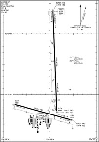
Runway 17/35
| Dimensions: | 10000 x 100 feet / 3048 x 30 meters | |
|---|---|---|
| Surface: | Asphalt in Good Condition | |
| Weight Limits: | S-30, D-45 | |
| Edge Lighting: | Medium Intensity | |
| Runway 17 | Runway 35 | |
| Coordinates: | N40°27.37' / W104°37.93' | N40°25.73' / W104°37.85' |
| Elevation: | 4696.8 | 4648.5 |
| Traffic Pattern: | Left | |
| Runway Heading: | 177° True | 357° True |
| Displaced Threshold: | 1100 Feet | |
| Markings: | Precision Instrument in good condition. | Precision Instrument in good condition. |
| Glide Slope Indicator | P2L (3.00° Glide Path Angle) | P2L (3.00° Glide Path Angle) |
| REIL: | Yes | Yes |
| Obstacles: | 56 ft Tree 2834 ft from runway, 514 ft right of center | |
Runway 10/28
| Dimensions: | 5801 x 100 feet / 1768 x 30 meters | |
|---|---|---|
| Surface: | Asphalt in Good Condition | |
| Weight Limits: | S-18, D-30 | |
| Edge Lighting: | Medium Intensity | |
| Runway 10 | Runway 28 | |
| Coordinates: | N40°25.84' / W104°38.77' | N40°25.59' / W104°37.56' |
| Elevation: | 4661.2 | 4644.8 |
| Traffic Pattern: | Left | Right |
| Runway Heading: | 105° True | 285° True |
| Markings: | Precision Instrument in good condition. | Precision Instrument in good condition. |
| Glide Slope Indicator | P2L (3.00° Glide Path Angle) | V4L (3.00° Glide Path Angle) |
| REIL: | Yes | Yes |
| Obstacles: | +10 FT DIRT ACCESS ROAD AT THLD & PARALLEL TO EXTDD CNTRLN; +9 FT CROPS 140 FT FM THLD 90 FT L & R OF CNTRLN. |
27 ft Pole 1485 ft from runway, 144 ft left of center |
Helipad H1
| Dimensions: | 20 x 20 feet / 6 x 6 meters | |
|---|---|---|
| Surface: | Concrete in Good Condition | |
Helipad H2
| Dimensions: | 20 x 20 feet / 6 x 6 meters | |
|---|---|---|
| Surface: | Concrete in Good Condition | |
Services Available
| Fuel: | 100LL (blue), Jet-A |
|---|---|
| Transient Storage: | Hangars,Tiedowns |
| Airframe Repair: | MAJOR |
| Engine Repair: | MAJOR |
| Bottled Oxygen: | HIGH/LOW |
| Bulk Oxygen: | NOT AVAILABLE |
| Other Services: | CROP DUSTING SERVICES,AIR AMBULANCE SERVICES,CHARTER SERVICE,PILOT INSTRUCTION,AIRCRAFT RENTAL |
Ownership Information
| Ownership: | Publicly owned | |
|---|---|---|
| Owner: | GREELEY-WELD CO ARPT AUTH | |
| PO BOX 727 | ||
| GREELEY, CO 80632 | ||
| 970-336-3000 | ||
| Manager: | COOPER ANDERSON | |
| PO BOX 727 | ||
| GREELEY, CO 80632 | ||
| (970) 336-3001 | ||
Operational Statistics
| Single Engine Aircraft Based on Field: | 125 | Statistics collected for 12 month period ending 2018-12-31 | |
|---|---|---|---|
| Multi-Engine Aircraft Based on Field: | 16 | Annual Commercial Operations: | none |
| Jet Aircraft Based on Field: | 6 | Annual Commuter Operations: | none |
| Helicopters Based on Field: | 3 | Annual Air Taxi Operations: | none |
| Military Aircraft Based on Field: | none | Annual Military Operations: | 500 |
| Gliders Based on Field: | none | Annual GA Local Operations: | 66096 |
| Ultralights Based on Field: | none | Annual GA Itinerant Operations: | 44064 |
Other Remarks
- THIS AIRPORT HAS BEEN SURVEYED BY THE NATIONAL GEODETIC SURVEY.
- RY 17/35 PREFERRED USE WHEN CROSS WIND COMPONENT EXCEEDS 12 KT ON RY 10/28.
- RWY 35 PREFERRED USE WHEN WIND LESS THAN 5 KNOTS. RY 35 PREFERRED FOR TGL.
- WILDLIFE AND BRIDS ON & INVOF APRT.
- OIL DRILLING RIGS UP TO 120 FT AGL ON AND INVICINTY OF AIRPORT.
- BE ALERT; INTENSIVE USAF STUDENT TRAINING IN VICINITY OF COLORADO SPRINGS & PUEBLO COLORADO.
- ACFT DEPG RWY28 AVOID SB TURN PRIOR TO XNG RWY10 THLD.
- FOR ATTENDANCE AFT HRS CALL 970-336-3010
- ACTVT MIRL RYS 10/28 & 17/35, & REIL RYS 10, 28, 17, & 35 - CTAF. PAPI RYS 10, 17, 35, & VASI RY 28 OPR 24 HRS.
Weather Minimums
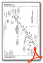
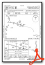
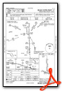
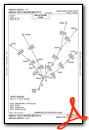
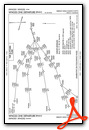
Standard Terminal Arrival (STAR) Charts
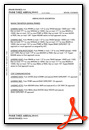
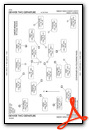
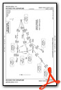
- BRNKO TWO (RNAV)
- BRNKO TWO (RNAV), CONT.1
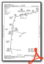
- BRNKO TWO (RNAV), CONT.2
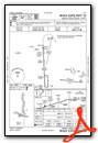
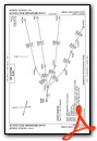
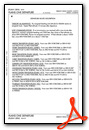
- DANDD ONE
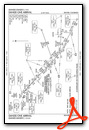
- DANDD ONE, CONT.1
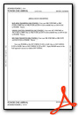
- LANDR THREE
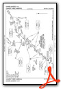
- LANDR THREE, CONT.1
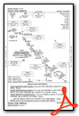
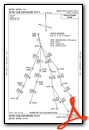
- LARKS THREE
- LARKS THREE, CONT.1
- PINNR THREE (RNAV)

- PINNR THREE (RNAV), CONT.1
- POWDR ONE
- POWDR ONE, CONT.1
- QUAIL ONE
- RAMMS EIGHT
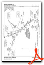
- RAMMS EIGHT, CONT.1
- TOMSN EIGHT

- TOMSN EIGHT, CONT.1

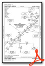
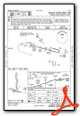
Instrument Approach Procedure (IAP) Charts
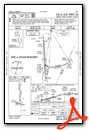
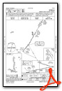
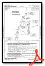
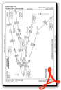
Departure Procedure (DP) Charts
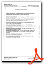
- DENVER TWO
- DENVER TWO, CONT.1
- ECHOO ONE (RNAV)
- ECHOO ONE (RNAV), CONT.1
- MRSHH TWO (RNAV)
- MRSHH TWO (RNAV), CONT.1
- PIKES TWO
- PLAINS ONE
- PLAINS ONE, CONT.1
- ROCKIES FIVE
- ROCKIES FIVE, CONT.1
- SKYEE ONE (RNAV)
- SKYEE ONE (RNAV), CONT.1
- WNGSS ONE (RNAV)
- WNGSS ONE (RNAV), CONT.1

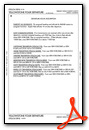
- YELLOWSTONE FOUR
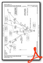
- YELLOWSTONE FOUR, CONT.1
Nearby Airports with Instrument Procedures
| ID | Name | Heading / Distance | ||
|---|---|---|---|---|
 |
KFNL | Northern Colorado Regional Airport | 272° | 17.3 |
|
KLMO | Vance Brand Airport | 236° | 29.3 |
|
KEIK | Erie Municipal Airport | 216° | 31.9 |
|
KDEN | Denver International Airport | 183° | 34.6 |
|
KFMM | Fort Morgan Municipal Airport | 098° | 38.5 |
|
KBJC | Rocky Mountain Metro Airport | 215° | 38.7 |
|
KCFO | Colorado Air and Space Port Airport | 173° | 39.4 |
|
KCYS | Cheyenne Regional/Jerry Olson Field Airport | 349° | 43.8 |
|
KBKF | Buckley Space Force Base Airport | 187° | 44.4 |
|
KAPA | Centennial Airport | 190° | 52.9 |
|
KGNB | Granby-Grand County Airport | 250° | 62.5 |
|
KIBM | Kimball Municipal/Robert E Arraj Field Airport | 043° | 62.6 |
Airport Images

By: gvermeulen


