Login
Register


GYH
Donaldson Field Airport
Official FAA Data Effective 2024-04-18 0901Z
Chart Supplement

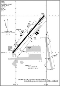
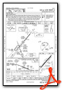
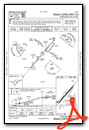
KGYH Airport Diagram
VFR Chart of KGYH
Sectional Charts at SkyVector.com
IFR Chart of KGYH
Enroute Charts at SkyVector.com
Location Information for KGYH
Coordinates: N34°45.50' / W82°22.58'Located 06 miles S of Greenville, South Carolina on 1300 acres of land. View all Airports in South Carolina.
Surveyed Elevation is 955 feet MSL.
Operations Data
|
|
Airport Communications
| AWOS-3: | 127.325 Tel. 864-277-5674 |
|---|---|
| DONALDSON TOWER: | 133.325 269.25 |
| DONALDSON GROUND: | 121.4 |
| GREER APPROACH: | 118.8 270.275 |
| GREER DEPARTURE: | 118.8 270.275 |
| CLEARANCE DELIVERY: | 121.4 |
| UNICOM: | 122.700 |
| BWALL DP: | 118.8 270.275 |
| CTAF: | 133.325 |
| BIMMR DP: | 118.8 270.275 |
| ATIS at GMU (5.5 N): | 127.075 |
| ASOS at GMU (5.5 N): | 127.075 864-239-0014 |
| ASOS at GSP (10.8 NE): | 134.25 864-879-0614 |
- APCH/DEP SVC PRVDD BY ATLANTA ARTCC ON FREQS 135.35/263.125 (OWING RCAG) WHEN APCH CTL CLSD.
Nearby Navigation Aids
|
| ||||||||||||||||||||||||||||||||||||||||||||||||||||||||||||


Runway 05/23
| Dimensions: | 8000 x 150 feet / 2438 x 46 meters | |
|---|---|---|
| Surface: | Concrete / Grooved in Good Condition | |
| Weight Limits: | 36 /R/C/W/T, S-94, D-121, ST-199 | |
| Edge Lighting: | High Intensity | |
| Runway 05 | Runway 23 | |
| Coordinates: | N34°44.99' / W82°23.10' | N34°46.00' / W82°22.07' |
| Elevation: | 955.8 | 918.9 |
| Traffic Pattern: | Right | Left |
| Runway Heading: | 40° True | 220° True |
| Markings: | Precision Instrument in good condition. | Precision Instrument in good condition. |
| Glide Slope Indicator | P4L (3.22° Glide Path Angle) | P4L (4.14° Glide Path Angle) |
| Approach Lights: | MALSR 1,400 Foot Medium-intensity Approach Lighting System with runway alignment indicator lights. | |
| Obstacles: | 42 ft Trees 1600 ft from runway, 650 ft left of center | |
Services Available
| Fuel: | 100LL (blue), Jet-A |
|---|---|
| Transient Storage: | Hangars,Tiedowns |
| Airframe Repair: | MAJOR |
| Engine Repair: | MAJOR |
| Bottled Oxygen: | NONE |
| Bulk Oxygen: | HIGH |
| Other Services: | CARGO HANDLING SERVICES,CHARTER SERVICE |
Ownership Information
| Ownership: | Publicly owned | |
|---|---|---|
| Owner: | GREENVILLE CITY/COUNTY | |
| 2 EXCHANGE ST | ||
| GREENVILLE, SC 29605 | ||
| (864) 918-8835 | ||
| Manager: | DANNY MOYD | |
| 2 EXCHANGE ST | ||
| GREENVILLE, SC 29605 | ||
| 864-277-3152 | ||
Operational Statistics
| Single Engine Aircraft Based on Field: | 30 | Statistics collected for 12 month period ending 2022-12-31 | |
|---|---|---|---|
| Multi-Engine Aircraft Based on Field: | 7 | Annual Commercial Operations: | none |
| Jet Aircraft Based on Field: | 3 | Annual Commuter Operations: | none |
| Helicopters Based on Field: | 1 | Annual Air Taxi Operations: | 11368 |
| Military Aircraft Based on Field: | 12 | Annual Military Operations: | 4052 |
| Gliders Based on Field: | none | Annual GA Local Operations: | 22093 |
| Ultralights Based on Field: | 1 | Annual GA Itinerant Operations: | 17130 |
Other Remarks
- LTD PRK, RAMP CLSD TO ALL TFC EXC MIL R/W ACFT WITH 24HR PPR. CTC ARNG OPS C803-299-5214. OPR 1230-2200Z++ MON-FRI, EXC HOL. LTD TRAN MAINT FOR CH47 AND UH72 ACFT ONLY.
- ARNG OPS PTD - 41.3 308.7 REMARKS: ARNG OPS C803-299-5214 (GREENVILLE OPS).
- TWY A CLSD TO WINGSPANS GTR THAN 79 FT WO PRIOR CDN WITH ARPT MGMT.
- SFC CONDS NOT RPRTD DAILY 9PM TO 7AM LOCAL.
- ACTVT MALSR RWY 05; HIRL RWY 05/23 - CTAF.
- BAK-14 (1502 FT).
- BAK-14 (1703 FT).
Weather Minimums

Standard Terminal Arrival (STAR) Charts
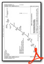
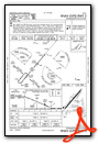
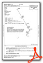
Instrument Approach Procedure (IAP) Charts
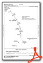
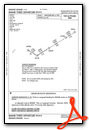
Departure Procedure (DP) Charts
Nearby Airports with Instrument Procedures
| ID | Name | Heading / Distance | ||
|---|---|---|---|---|
 |
KGMU | Greenville Downtown Airport | 013° | 5.5 |
|
KGSP | Greenville Spartanburg International Airport | 043° | 11.3 |
|
KLQK | Pickens County Airport | 280° | 16.4 |
|
KSPA | Spartanburg Downtown Memorial/Simpson Field Airport | 065° | 22.8 |
|
KAND | Anderson Regional Airport | 226° | 22.8 |
|
KCEU | Oconee County Regional Airport | 258° | 25.7 |
|
KLUX | Laurens County Airport | 125° | 26.0 |
|
KGRD | Greenwood County Airport | 160° | 32.3 |
|
35A | Union County, Troy Shelton Field Airport | 096° | 36.6 |
|
KAVL | Asheville Regional Airport | 348° | 41.4 |
|
18A | Franklin-Hart Airport | 236° | 45.0 |
|
KEOE | Newberry County Airport | 126° | 45.3 |
Airport Images
Do you have a recent image of this airport? Upload it here!


