Login
Register


GYL
Glencoe Municipal Airport
Official FAA Data Effective 2024-04-18 0901Z
Chart Supplement

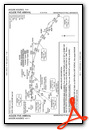
VFR Chart of KGYL
Sectional Charts at SkyVector.com
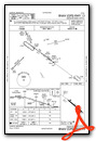
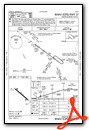
IFR Chart of KGYL
Enroute Charts at SkyVector.com
Location Information for KGYL
Coordinates: N44°45.36' / W94°4.89'Located 03 miles SE of Glencoe, Minnesota on 30 acres of land. View all Airports in Minnesota.
Surveyed Elevation is 992 feet MSL.
Operations Data
|
|
Airport Communications
| AWOS-3: | 119.625 Tel. 320-864-5830 |
|---|---|
| MINNEAPOLIS APPROACH: | 134.7 284.7 |
| MINNEAPOLIS DEPARTURE: | 134.7 284.7 |
| UNICOM: | 122.800 |
| AGUDE STAR: | 335.5 |
| CTAF: | 122.800 |
| AWOS-3 at HCD (14.3 NW): | 118.525 320-587-3343 |
| AWOS-3PT at CFE (26.2 NE): | 120.45 763-684-0762 |
| ASOS at FCM (26.4 E): | 952-941-4156 |
Nearby Navigation Aids
|
| ||||||||||||||||||||||||||||||||||||||||||||||||


Runway 13/31
| Dimensions: | 3300 x 75 feet / 1006 x 23 meters | |
|---|---|---|
| Surface: | Asphalt in Good Condition | |
| Edge Lighting: | Medium Intensity | |
| Runway 13 | Runway 31 | |
| Coordinates: | N44°45.52' / W94°5.19' | N44°45.20' / W94°4.58' |
| Elevation: | 992.4 | 991.3 |
| Traffic Pattern: | Left | Left |
| Runway Heading: | 127° True | 307° True |
| Markings: | Non-Precision Instrument in good condition. | Non-Precision Instrument in good condition. |
| Glide Slope Indicator | P4L (3.00° Glide Path Angle) | P4L (3.00° Glide Path Angle) |
| REIL: | Yes | Yes |
Services Available
| Fuel: | 100LL (blue) |
|---|---|
| Transient Storage: | Tiedowns |
| Airframe Repair: | NONE |
| Engine Repair: | NONE |
| Bottled Oxygen: | NONE |
| Bulk Oxygen: | NONE |
Ownership Information
| Ownership: | Publicly owned | |
|---|---|---|
| Owner: | CITY OF GLENCOE | |
| 1107 11TH ST E STE 107 | ||
| GLENCOE, MN 55336-2327 | ||
| 320-864-5586 | ||
| Manager: | MARK LARSON | |
| 1107 11TH ST E STE 107 | ||
| GLENCOE, MN 55336-2327 | ||
| 320-864-5586 | ||
Operational Statistics
| Single Engine Aircraft Based on Field: | 33 | Statistics collected for 12 month period ending 2018-04-30 | |
|---|---|---|---|
| Multi-Engine Aircraft Based on Field: | 1 | Annual Commercial Operations: | none |
| Jet Aircraft Based on Field: | none | Annual Commuter Operations: | none |
| Helicopters Based on Field: | none | Annual Air Taxi Operations: | none |
| Military Aircraft Based on Field: | none | Annual Military Operations: | none |
| Gliders Based on Field: | none | Annual GA Local Operations: | 7810 |
| Ultralights Based on Field: | none | Annual GA Itinerant Operations: | 2805 |
Other Remarks
- DEER ON & INVOF ARPT.
- ULTRALIGHT ACT ON & INVOF ARPT.
- FOR CD CTC MINNEAPOLIS APCH AT 612-726-9086.
- 0LL FUEL AVBL H24 VIA CREDIT CARD.
- ACTVT OR INCR INTST REIL RWY 13 & 31; PAPI RWY 13 & 31; MIRL RWY 13/31 - CTAF. MIRL RWY 13/31 PRESET LOW INTST.
Weather Minimums
Standard Terminal Arrival (STAR) Charts
Instrument Approach Procedure (IAP) Charts
Nearby Airports with Instrument Procedures
| ID | Name | Heading / Distance | ||
|---|---|---|---|---|
 |
KHCD | Hutchinson Municipal/Butler Field Airport | 295° | 14.3 |
|
KCFE | Buffalo Municipal Airport | 022° | 26.2 |
|
KFCM | Flying Cloud Airport | 080° | 27.0 |
|
KLJF | Litchfield Municipal Airport | 318° | 27.4 |
|
KMGG | Maple Lake Municipal-Bill Mavencamp Sr Field Airport | 008° | 29.1 |
|
KULM | New Ulm Municipal Airport | 214° | 31.9 |
|
KMKT | Mankato Regional Airport | 167° | 32.7 |
|
KMIC | Crystal Airport | 059° | 36.1 |
|
KLVN | Airlake Airport | 101° | 37.3 |
|
KMSP | Minneapolis-St Paul International/Wold-Chamberlain Airport | 078° | 37.5 |
|
KOVL | Olivia Regional Airport | 272° | 40.7 |
|
KFBL | Faribault Municipal-Liz Wall Strohfus Field Airport | 127° | 41.8 |
Airport Images
Do you have a recent image of this airport? Upload it here!


