Login
Register


GYY
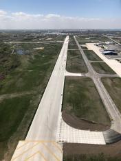
Gary/Chicago International Airport
Official FAA Data Effective 2024-04-18 0901Z
Chart Supplement

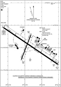
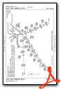
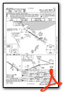
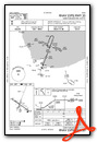
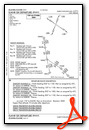
KGYY Airport Diagram
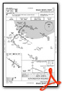
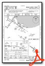
VFR Chart of KGYY
Sectional Charts at SkyVector.com
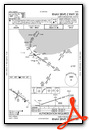
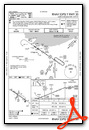
IFR Chart of KGYY
Enroute Charts at SkyVector.com
Location Information for KGYY
Coordinates: N41°37.03' / W87°24.87'Located 03 miles NW of Gary, Indiana on 763 acres of land. View all Airports in Indiana.
Surveyed Elevation is 596 feet MSL.
Operations Data
|
|
Airport Communications
| ATIS: | 134.575 |
|---|---|
| AWOS-3PT: | 134.575 Tel. 219-944-0010 |
| GARY TOWER: | 125.6 |
| GARY GROUND: | 121.9 |
| CHICAGO APPROACH: | 133.1 285.6 |
| CHICAGO DEPARTURE: | 133.1 285.6 |
| MOTIF STAR: | 128.2 353.875 |
| ARNG OPS: | 139.6 245.7 38.3 |
| GOSHEN STAR: | 128.2 353.875 |
| CTAF: | 125.600 |
| LUCIT STAR: | 133.1 285.6 |
| AWOS-3PT at IGQ (7.1 SW): | 119.275 708-889-6319 |
| ASOS at MDW (18.2 NW): | 773-884-4424 |
| D-ATIS at MDW (18.2 NW): | 132.75 |
- COMMUNICATIONS PRVDD BY TERRE HAUTE RADIO ON FREQ 122.3 (CROWNPOINT RCO).
Nearby Navigation Aids
|
| ||||||||||||||||||||||||||||||||||||||||||||||||||||||||||||


Runway 12/30
| Dimensions: | 8859 x 150 feet / 2700 x 46 meters | |
|---|---|---|
| Surface: | Concrete / Grooved in Good Condition | |
| Weight Limits: | 63 /F/A/X/T, S-75, D-157, ST-175, DT-250 | |
| Edge Lighting: | High Intensity | |
| Runway 12 | Runway 30 | |
| Coordinates: | N41°37.45' / W87°25.64' | N41°36.63' / W87°24.03' |
| Elevation: | 596.8 | 591.3 |
| Traffic Pattern: | Left | Left |
| Runway Heading: | 124° True | 304° True |
| Displaced Threshold: | 900 Feet | |
| Declared Distances: | TORA:8859 TODA:8859 ASDA:7959 LDA:7959 | TORA:8859 TODA:8859 ASDA:8859 LDA:7959 |
| Markings: | Precision Instrument in good condition. | Precision Instrument in good condition. |
| Glide Slope Indicator | P4L (3.00° Glide Path Angle) | P4L (3.00° Glide Path Angle) |
| RVR Equipment | Rollout | Touchdown |
| Approach Lights: | MALSR 1,400 Foot Medium-intensity Approach Lighting System with runway alignment indicator lights. | |
| REIL: | Yes | |
| Centerline Lights: | Yes | Yes |
| Obstacles: | 93 ft Antenna 3777 ft from runway, 1248 ft left of center | 68 ft Pole 3422 ft from runway, 220 ft left of center |
Runway 02/20
NA FOR UNSKED ACR WITH AT LEAST 31 PAX SEATS EXC FOR TAX BTN RWY 12/30 & TWY A. | ||
| Dimensions: | 3604 x 100 feet / 1098 x 30 meters | |
|---|---|---|
| Surface: | Asphalt in Fair Condition | |
| Weight Limits: | 21 /F/A/X/T, S-18, D-28 | |
| Edge Lighting: | Medium Intensity | |
| Runway 02 | Runway 20 | |
| Coordinates: | N41°36.74' / W87°25.10' | N41°37.29' / W87°24.82' |
| Elevation: | 589.1 | 589.3 |
| Traffic Pattern: | Left | Left |
| Runway Heading: | 21° True | 201° True |
| Declared Distances: | TORA:3604 TODA:3604 ASDA:3604 LDA:3604 | TORA:3604 TODA:3604 ASDA:3604 LDA:3604 |
| Markings: | Non-Precision Instrument in fair condition. | Non-Precision Instrument in fair condition. |
| Glide Slope Indicator | P2L (3.00° Glide Path Angle) | P2L (3.00° Glide Path Angle) |
| REIL: | Yes | Yes |
| Obstacles: | 42 ft Road 1050 ft from runway | 37 ft Pole 833 ft from runway, 289 ft right of center |
Services Available
| Fuel: | 100LL (blue), Jet-A |
|---|---|
| Transient Storage: | Hangars,Tiedowns |
| Airframe Repair: | MAJOR |
| Engine Repair: | MAJOR |
| Bottled Oxygen: | HIGH |
| Bulk Oxygen: | NOT AVAILABLE |
| Other Services: | CARGO HANDLING SERVICES,CHARTER SERVICE,PILOT INSTRUCTION,AIRCRAFT RENTAL |
Ownership Information
| Ownership: | Publicly owned | |
|---|---|---|
| Owner: | GARY/CHICAGO ARPT AUTH DIST | |
| 6001 INDUSTRIAL HWY | ||
| GARY, IN 46406 | ||
| 219-949-9722 | ||
| Manager: | DANIEL VICARI | |
| 6001-C AIRPORT RD | ||
| GARY, IN 46406 | ||
| 219-949-4925 | ||
Operational Statistics
| Single Engine Aircraft Based on Field: | 27 | Statistics collected for 12 month period ending 2022-12-31 | |
|---|---|---|---|
| Multi-Engine Aircraft Based on Field: | 5 | Annual Commercial Operations: | 470 |
| Jet Aircraft Based on Field: | 44 | Annual Commuter Operations: | none |
| Helicopters Based on Field: | 3 | Annual Air Taxi Operations: | 2622 |
| Military Aircraft Based on Field: | 7 | Annual Military Operations: | 1642 |
| Gliders Based on Field: | none | Annual GA Local Operations: | 5576 |
| Ultralights Based on Field: | none | Annual GA Itinerant Operations: | 11744 |
Other Remarks
- BIRDS & WILDLIFE ON & INVOF ARPT.
- UNCTLD VEHICLES N SIDE RAMPS.
- TWY A, A1-A8 & C NORTH OF RWY 12/30 AVBL TO ACR MORE THAN 9 PAX SEATS.
- TWY F MIL USE ONLY.
- LINE OF SIGHT NA BTN INTERSECTING RWY ENDS.
- ARNG: OPS 1230Z-2330Z++ TUES-FRI. MIL F/W OR R/W PRKG OR SVC ON ARNG RAMP 24 HR PPR - 219-977-2017.
- FOR CD WHEN ATCT IS CLSD CTC CHICAGO APCH AT 847-289-0926.
- WHEN ATCT CLSD ACTVT MALSR RWY 30; REIL RWY 02, 12 & 20; MIRL RWY 02/20; HIRL RWY 12/30 - CTAF.
Weather Minimums

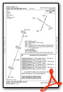
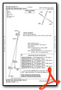
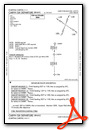
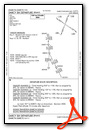
Standard Terminal Arrival (STAR) Charts
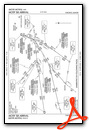
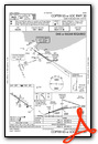
Instrument Approach Procedure (IAP) Charts
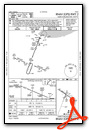
Departure Procedure (DP) Charts
Nearby Airports with Instrument Procedures
| ID | Name | Heading / Distance | ||
|---|---|---|---|---|
 |
05C | Griffith-Merrillville Airport | 173° | 5.9 |
|
KIGQ | Lansing Municipal Airport | 226° | 7.2 |
|
3HO | Hobart Sky Ranch Airport | 118° | 7.7 |
|
KMDW | Chicago Midway International Airport | 303° | 18.2 |
|
C56 | Bult Field Airport | 219° | 18.7 |
|
KVPZ | Porter County Regional Airport | 117° | 20.8 |
|
KMGC | Michigan City Municipal-Phillips Field Airport | 078° | 27.2 |
|
KLOT | Lewis University Airport | 269° | 30.7 |
|
KPPO | La Porte Municipal Airport | 094° | 30.7 |
|
KORD | Chicago O'Hare International Airport | 314° | 30.9 |
|
1C5 | Bolingbrook's Clow International Airport | 278° | 32.5 |
|
KPWK | Chicago Exec Airport | 323° | 36.9 |