Login
Register


GZH
Evergreen Regional/Middleton Field Airport
Official FAA Data Effective 2024-04-18 0901Z
Chart Supplement

VFR Chart of KGZH
Sectional Charts at SkyVector.com
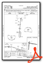
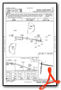
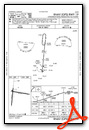
IFR Chart of KGZH
Enroute Charts at SkyVector.com
Location Information for KGZH
Coordinates: N31°24.90' / W87°2.60'Located 05 miles W of Evergreen, Alabama on 400 acres of land. View all Airports in Alabama.
Surveyed Elevation is 259 feet MSL.
Operations Data
|
|
Airport Communications
| ASOS: | 133.425 Tel. 251-578-1438 |
|---|---|
| CTAF: | 122.700 |
| UNICOM: | 122.700 |
| AWOS-3PT at 12J (21.8 S): | 119.325 251-809-2987 |
| ASOS at 79J (34.0 E): | 134.875 334-222-9770 |
| ASOS at PRN (34.0 NE): | 120.0 334-383-9676 |
- APCH/DEP SVC PRVDD BY JACKSONVILLE ARTCC ON FREQS 134.15/338.3 (CRESTVIEW RCAG).
Nearby Navigation Aids
|
| ||||||||||||||||||||||||||||||||||||||||||||||||||||||||||||


Runway 01/19
| Dimensions: | 5005 x 150 feet / 1526 x 46 meters | |
|---|---|---|
| Surface: | Asphalt in Fair Condition | |
| Edge Lighting: | Medium Intensity | |
| Runway 01 | Runway 19 | |
| Coordinates: | N31°24.39' / W87°2.87' | N31°25.21' / W87°2.78' |
| Elevation: | 251.7 | 257.8 |
| Traffic Pattern: | Left | Left |
| Runway Heading: | 5° True | 185° True |
| Markings: | Non-Precision Instrument in fair condition. | Non-Precision Instrument in fair condition. |
| Obstacles: | 85 ft Tree 1461 ft from runway, 227 ft right of center | |
Runway 10/28
| Dimensions: | 5004 x 150 feet / 1525 x 46 meters | |
|---|---|---|
| Surface: | Asphalt in Good Condition | |
| Weight Limits: | S-30, D-50 | |
| Edge Lighting: | Medium Intensity | |
| Runway 10 | Runway 28 | |
| Coordinates: | N31°25.07' / W87°2.86' | N31°24.93' / W87°1.91' |
| Elevation: | 258.9 | 248.8 |
| Traffic Pattern: | Left | Left |
| Runway Heading: | 100° True | 280° True |
| Markings: | Non-Precision Instrument in fair condition. | Non-Precision Instrument in fair condition. |
| Glide Slope Indicator | P4L (3.00° Glide Path Angle) | |
| Obstacles: | 64 ft Tree 1233 ft from runway, 29 ft left of center | 61 ft Tree 1426 ft from runway, 173 ft left of center |
Services Available
| Fuel: | 100LL (blue), Jet A+ |
|---|---|
| Transient Storage: | Hangars,Tiedowns |
| Airframe Repair: | NOT AVAILABLE |
| Engine Repair: | NOT AVAILABLE |
| Bottled Oxygen: | NONE |
| Bulk Oxygen: | NONE |
Ownership Information
| Ownership: | Publicly owned | |
|---|---|---|
| Owner: | CITY OF EVERGREEN | |
| 355 EAST FRONT ST PO BOX 229 | ||
| EVERGREEN, AL 36401 | ||
| 251-578-1574 | ||
| Manager: | ANDREW ASHBURN | |
| 14134 US HWY 84 WEST | ||
| EVERGREEN, AL 36401 | ||
| 251-369-2091 | ||
Operational Statistics
| Single Engine Aircraft Based on Field: | 10 | Statistics collected for 12 month period ending 2017-11-01 | |
|---|---|---|---|
| Multi-Engine Aircraft Based on Field: | none | Annual Commercial Operations: | none |
| Jet Aircraft Based on Field: | none | Annual Commuter Operations: | none |
| Helicopters Based on Field: | none | Annual Air Taxi Operations: | none |
| Military Aircraft Based on Field: | none | Annual Military Operations: | 127997 |
| Gliders Based on Field: | none | Annual GA Local Operations: | 2333 |
| Ultralights Based on Field: | none | Annual GA Itinerant Operations: | 3675 |
Other Remarks
- INTENSIVE NAVY PROP TRNG MON-FRI SR-SS.
- DIST MKRS ON BOTH SIDES OF RWYS 10/28 & 01/19 ARE US NAVY EQUIP.
- TRAILER MANNED BY USN RWY DUTY OFFICER WHEN A110-01 ACTIVE. PERM USN CRASH CREW.
- FOR CD CTC JACKSONVILLE ARTCC AT 904-845-1592.
- FOR AFT HRS SVC CALL 251-369-2091.
- MARKINGS FADED.
- MARKINGS FADED.
- MARKINGS FADED.
- MARKINGS FADED.
- ACTVT PAPI RWY 10; MIRL RWYS 01/19 & 10/28 - CTAF.
Weather Minimums

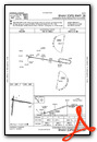
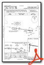
Instrument Approach Procedure (IAP) Charts
Nearby Airports with Instrument Procedures
| ID | Name | Heading / Distance | ||
|---|---|---|---|---|
 |
KMVC | Monroe County Aeroplex Airport | 279° | 16.0 |
|
12J | Brewton Municipal Airport | 183° | 21.8 |
|
0R1 | Atmore Municipal Airport | 221° | 31.6 |
|
79J | South Alabama Regional At Bill Benton Field Airport | 100° | 34.1 |
|
KPRN | Mac Crenshaw Memorial Airport | 040° | 34.0 |
|
61A | Camden Municipal Airport | 335° | 37.0 |
|
KNSE | Whiting Field NAS North Airport | 178° | 41.5 |
|
KNDZ | Whiting Field NAS South Airport | 177° | 42.9 |
|
0J4 | Florala Municipal Airport | 120° | 43.8 |
|
4R3 | Jackson Municipal Airport | 274° | 43.9 |
|
KCEW | Bob Sikes Airport | 144° | 46.6 |
|
2R4 | Peter Prince Field Airport | 176° | 46.6 |
Airport Images
Do you have a recent image of this airport? Upload it here!


