Login
Register


HEF
Manassas Regional/Harry P Davis Field Airport
Official FAA Data Effective 2024-04-18 0901Z
Chart Supplement

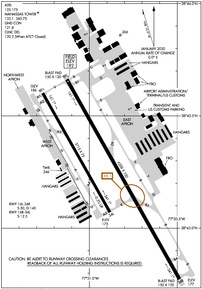
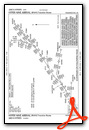
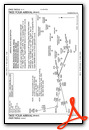
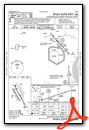
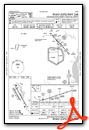
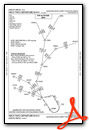
KHEF Airport Diagram
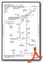
VFR Chart of KHEF
Sectional Charts at SkyVector.com
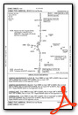
IFR Chart of KHEF
Enroute Charts at SkyVector.com
Location Information for KHEF
Coordinates: N38°43.26' / W77°30.91'Located 28 miles WSW of Washington, Dist. of Columbia on 888 acres of land. View all Airports in Dist. of Columbia.
Surveyed Elevation is 192 feet MSL.
TPA - 1200 MSL SINGLE ENGINE & LGT TWIN ACFT; 1500 MSL MED TWIN & TURBOPROP ACFT; 1000 MSL HELICOPTER.
Operations Data
|
|
Airport Communications
| ATIS: | 125.175 (703-361-6160) |
|---|---|
| AWOS-3PT: | Tel. 703-361-6160 |
| MANASSAS TOWER: | 133.1 360.75 |
| MANASSAS GROUND: | 121.8 |
| POTOMAC APPROACH: | 128.525 306.925 |
| POTOMAC DEPARTURE: | 128.525 306.925 |
| CLEARANCE DELIVERY: | 120.2 120.2 ;WHEN HEF TWR CLSD |
| TRSTN STAR: | 126.75 307.2 |
| GIBBZ STAR: | 120.45 306.925 |
| COATT STAR: | 128.525 306.925 |
| TIKEE STAR: | 120.45 306.925 |
| GABBE DP: | 128.525 306.925 |
| HYPER STAR: | 133.0 288.35 |
| HIICH DP: | 128.525 306.925 |
| CTAF: | 133.100 |
| AWOS-3 at HWY (12.3 SW): | 120.350 540-788-4078 |
| ASOS at IAD (13.3 N): | 134.85 703-661-2990 |
| D-ATIS at IAD (13.8 N): | 134.85 |
Nearby Navigation Aids
|
| ||||||||||||||||||||||||||||||||||||||||||||||||||||||||||||


Runway 16L/34R
| Dimensions: | 6200 x 100 feet / 1890 x 30 meters | |
|---|---|---|
| Surface: | Asphalt / Grooved in Good Condition | |
| Weight Limits: | S-50, D-140 | |
| Edge Lighting: | High Intensity | |
| Runway 16L | Runway 34R | |
| Coordinates: | N38°43.66' / W77°31.13' | N38°42.77' / W77°30.49' |
| Elevation: | 192.2 | 177.4 |
| Traffic Pattern: | Right | |
| Runway Heading: | 151° True | 331° True |
| Markings: | Precision Instrument in good condition. | Non-Precision Instrument in good condition. |
| Glide Slope Indicator | P4L (3.00° Glide Path Angle) | P4L (3.00° Glide Path Angle) |
| Approach Lights: | MALSR 1,400 Foot Medium-intensity Approach Lighting System with runway alignment indicator lights. | MALSF 1,400 Foot Medium-intensity Approach Lighting System with sequenced flashers. |
| Obstacles: | 64 ft Trees 2259 ft from runway, 385 ft left of center | 102 ft Trees 2964 ft from runway, 401 ft left of center |
Runway 16R/34L
| Dimensions: | 3715 x 75 feet / 1132 x 23 meters | |
|---|---|---|
| Surface: | Asphalt in Excellent Condition | |
| Weight Limits: | S-12 | |
| Edge Lighting: | Medium Intensity | |
| Runway 16R | Runway 34L | |
| Coordinates: | N38°43.60' / W77°31.26' | N38°43.07' / W77°30.88' |
| Elevation: | 185.7 | 175.1 |
| Traffic Pattern: | Right | Left |
| Runway Heading: | 151° True | 331° True |
| Markings: | Non-Precision Instrument in good condition. | Non-Precision Instrument in good condition. |
| Glide Slope Indicator | P2L (3.00° Glide Path Angle) | P2L (3.00° Glide Path Angle) |
| REIL: | Yes | Yes |
| Obstacles: | 105 ft Tree 3088 ft from runway, 521 ft right of center | 30 ft Trees 659 ft from runway, 42 ft right of center |
Services Available
| Fuel: | 100LL (blue), Jet-A |
|---|---|
| Transient Storage: | Hangars,Tiedowns |
| Airframe Repair: | MAJOR |
| Engine Repair: | MAJOR |
| Bottled Oxygen: | LOW |
| Bulk Oxygen: | HIGH/LOW |
| Other Services: | AVIONICS,CHARTER SERVICE,PILOT INSTRUCTION,AIRCRAFT RENTAL,AIRCRAFT SALES |
Ownership Information
| Ownership: | Publicly owned | |
|---|---|---|
| Owner: | CITY OF MANASSAS | |
| 10600 HARRY J. PARRISH BOULEVARD | ||
| MANASSAS, VA 20110 | ||
| 703-361-1882 | ||
| Manager: | JUAN RIVERA | |
| 10600 HARRY J. PARRISH BOULEVARD | ||
| MANASSAS, VA 20110 | ||
| 703-361-1882 | ||
Operational Statistics
| Single Engine Aircraft Based on Field: | 287 | Statistics collected for 12 month period ending 2021-12-31 | |
|---|---|---|---|
| Multi-Engine Aircraft Based on Field: | 46 | Annual Commercial Operations: | none |
| Jet Aircraft Based on Field: | 24 | Annual Commuter Operations: | none |
| Helicopters Based on Field: | 17 | Annual Air Taxi Operations: | 1034 |
| Military Aircraft Based on Field: | none | Annual Military Operations: | 1034 |
| Gliders Based on Field: | none | Annual GA Local Operations: | 26298 |
| Ultralights Based on Field: | none | Annual GA Itinerant Operations: | 59534 |
Other Remarks
- BIRDS & DEER ON & INVOF ARPT.
- HELICOPTER OPS OVER RESIDENTIAL AREAS BLW 1000 FT SHOULD BE AVOIDED; CTC AMGR 703-361-1882 FOR INFO.
- US CUSTOMS AVBL MON-SUN 1000-0400Z. CALL COMMAND CENTER 703-661-2800 FOR APNTMT. 24 HR NOTICE RQRD. ALL WKEND FLIGHTS MUST BE ARNGD BFR 1700 LOCAL ON FRI BFR.
- FOR CD WHEN ATCT IS CLSD CTC POTOMAC APCH AT 866-709-4993.
- TRML APN FOR TSNT AND US CUST PRKG.
- TWY B SAFETY AREA WID 44 FT LATERALLY EAST SIDE FM TWY E TO TWY G.
- WHEN ATCT CLSD ACTVT MALSR RWY 16L; MALSF RWY 34R; REILS RWY 16R & 34L; HIRL RWY 16L/34R, MIRL RWY 16R/34L - CTAF.
- TPA - 1200 MSL SINGLE ENGINE & LGT TWIN ACFT; 1500 MSL MED TWIN & TURBOPROP ACFT; 1000 MSL HELICOPTER.
Weather Minimums
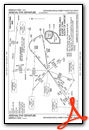
Standard Terminal Arrival (STAR) Charts
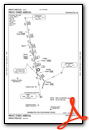
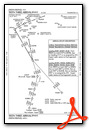
Instrument Approach Procedure (IAP) Charts
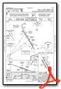
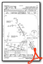
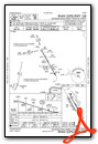
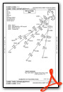
Departure Procedure (DP) Charts

Nearby Airports with Instrument Procedures
| ID | Name | Heading / Distance | ||
|---|---|---|---|---|
 |
KHWY | Warrenton/Fauquier Airport | 228° | 12.2 |
|
KIAD | Washington Dulles International Airport | 010° | 13.8 |
|
KDAA | Davison AAF Airport | 091° | 15.7 |
|
KNYG | Quantico Mcaf (Turner Field) Airport | 142° | 16.4 |
|
KRMN | Stafford Regional Airport | 171° | 19.6 |
|
KCJR | Culpeper Regional Airport | 234° | 20.0 |
|
KJYO | Leesburg Exec Airport | 354° | 21.5 |
|
2W5 | Maryland Airport | 109° | 22.1 |
|
KDCA | Ronald Reagan Washington Ntl Airport | 070° | 23.7 |
|
KVKX | Potomac Airfield Airport | 086° | 26.3 |
|
KEZF | Shannon Airport | 173° | 27.4 |
|
KADW | Joint Base Andrews Airport | 079° | 30.9 |
Fuel Providers

Airport Images
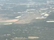
By: Big Orange Bird

By: laser


