Login
Register


HIB
Range Regional Airport
Official FAA Data Effective 2024-04-18 0901Z
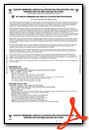
Chart Supplement

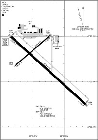
KHIB Airport Diagram
VFR Chart of KHIB
Sectional Charts at SkyVector.com
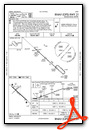
IFR Chart of KHIB
Enroute Charts at SkyVector.com
Location Information for KHIB
Coordinates: N47°23.19' / W92°50.34'Located 04 miles SE of Hibbing, Minnesota on 1600 acres of land. View all Airports in Minnesota.
Surveyed Elevation is 1353 feet MSL.
Operations Data
|
|
Airport Communications
| ASOS: | 126.425 Tel. 218-263-8384 |
|---|---|
| DULUTH APPROACH: | 125.45 233.7 |
| DULUTH DEPARTURE: | 125.45 233.7 |
| CLEARANCE DELIVERY: | 127.4 |
| UNICOM: | 123.000 |
| CTAF: | 123.000 |
| AWOS-3 at EVM (14.1 E): | 118.825 218-744-2369 |
| AWOS-3 at CQM (26.9 N): | 118.175 218-666-2539 |
| AWOS-3PT at GPZ (29.4 W): | 118.425 218-326-8337 |
Nearby Navigation Aids
|
| ||||||||||||||||||||||||||||||||||||||||||||||||||||||


Runway 13/31
| Dimensions: | 6758 x 150 feet / 2060 x 46 meters | |
|---|---|---|
| Surface: | Asphalt / Grooved in Excellent Condition | |
| Weight Limits: | 33 /F/C/X/T, S-60, D-100, ST-160 | |
| Edge Lighting: | High Intensity | |
| Runway 13 | Runway 31 | |
| Coordinates: | N47°23.50' / W92°50.87' | N47°22.75' / W92°49.65' |
| Elevation: | 1353.7 | 1338.2 |
| Traffic Pattern: | Left | Left |
| Runway Heading: | 132° True | 312° True |
| Declared Distances: | TORA:6758 TODA:6758 ASDA:6758 LDA:6758 | TORA:6758 TODA:6758 ASDA:6758 LDA:6758 |
| Markings: | Precision Instrument in good condition. | Precision Instrument in good condition. |
| Glide Slope Indicator | P4L (3.00° Glide Path Angle) | P4L (2.90° Glide Path Angle) |
| Approach Lights: | MALSR 1,400 Foot Medium-intensity Approach Lighting System with runway alignment indicator lights. | MALSR 1,400 Foot Medium-intensity Approach Lighting System with runway alignment indicator lights. |
Runway 04/22
CLSD TO SKEDD ACR OPS GTR THAN 9 PAX SEATS OR UNSKED ACR OPS GTR THAN 30 PAX SEATS. CLSD AT NGT. | ||
| Dimensions: | 3075 x 75 feet / 937 x 23 meters | |
|---|---|---|
| Surface: | Asphalt in Excellent Condition | |
| Weight Limits: | 3 /F/B/Y/U, S-35, D-45 | |
| Runway 04 | Runway 22 | |
| Coordinates: | N47°23.18' / W92°50.79' | N47°23.51' / W92°50.23' |
| Elevation: | 1348.9 | 1352.0 |
| Traffic Pattern: | Left | Left |
| Runway Heading: | 49° True | 229° True |
| Declared Distances: | TORA:3075 TODA:3075 ASDA:3075 LDA:3075 | TORA:3075 TODA:3075 ASDA:3075 LDA:3075 |
| Markings: | Non-Precision Instrument in good condition. | Non-Precision Instrument in good condition. |
| Obstacles: | 10 ft Road 310 ft from runway, 250 ft right of center | 17 ft Road 930 ft from runway, 350 ft right of center |
Services Available
| Fuel: | 100LL (blue), Jet-A |
|---|---|
| Transient Storage: | Tiedowns |
| Airframe Repair: | MAJOR |
| Engine Repair: | MAJOR |
| Bottled Oxygen: | NONE |
| Bulk Oxygen: | NONE |
| Other Services: | AIR AMBULANCE SERVICES,AVIONICS |
Ownership Information
| Ownership: | Publicly owned | |
|---|---|---|
| Owner: | CHISHOLM-HIBBING AIRPORT | |
| 11038 HIGHWAY 37 | ||
| HIBBING, MN 55746-8203 | ||
| 218-262-3451 | ||
| Manager: | BARRETT ZIEMER | |
| 11038 HIGHWAY 37 | ||
| HIBBING, MN 55746-8203 | ||
| 218-262-3451 | ||
Operational Statistics
| Single Engine Aircraft Based on Field: | 40 | Statistics collected for 12 month period ending 2022-12-31 | |
|---|---|---|---|
| Multi-Engine Aircraft Based on Field: | 1 | Annual Commercial Operations: | 2525 |
| Jet Aircraft Based on Field: | none | Annual Commuter Operations: | none |
| Helicopters Based on Field: | 1 | Annual Air Taxi Operations: | 2225 |
| Military Aircraft Based on Field: | none | Annual Military Operations: | 100 |
| Gliders Based on Field: | none | Annual GA Local Operations: | 14000 |
| Ultralights Based on Field: | none | Annual GA Itinerant Operations: | 10000 |
Other Remarks
- DIVD ACFT LIMITATIONS - NO INTL PSGR PROCESSING. ONLY ONE ACR GATE. LTD STERILE AREA SPACE (125 PSGRS). VENDING CONCESSIONS ONLY.
- FOR CD CTC DULUTH APCH AT 218-740-5950.
- BIRDS ON & INVOF ARPT.
- FLD CONDS UNMON 2200-0600.
- ACTVT OR INCR INTST MALSR RWY 13 & 31; HIRL RWY 13/31 - CTAF. PAPI RWY 13 & 31 OPR CONSLY; HIRL RWY 13/31 PRESET LOW INTST.
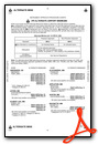
Weather Minimums
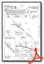
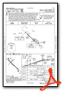
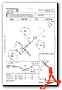
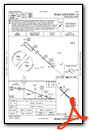
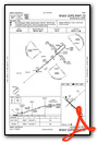
Instrument Approach Procedure (IAP) Charts
Nearby Airports with Instrument Procedures
| ID | Name | Heading / Distance | ||
|---|---|---|---|---|
 |
KEVM | Eveleth/Virginia Municipal Airport | 080° | 14.1 |
|
KCQM | Cook Municipal Airport | 013° | 26.9 |
|
KGPZ | Grand Rapids/Itasca County-Gordon Newstrom Field Airport | 249° | 29.4 |
|
12D | Tower Municipal Airport | 040° | 34.3 |
|
KORB | Orr Regional Airport | 358° | 37.8 |
|
KFOZ | Bigfork Municipal Airport | 306° | 40.7 |
|
KDLH | Duluth International Airport | 140° | 42.1 |
|
KCOQ | Cloquet/Carlton County Airport | 161° | 43.4 |
|
KELO | Ely Municipal Airport | 056° | 48.7 |
|
KTWM | Richard B Helgeson Airport | 113° | 49.1 |
|
KHZX | Isedor Iverson Airport | 202° | 50.0 |
|
KDYT | Sky Harbor Airport | 140° | 51.5 |
Airport Images
Do you have a recent image of this airport? Upload it here!


