Login
Register


HPN
Westchester County Airport
Official FAA Data Effective 2024-04-18 0901Z
From the Flight Deck
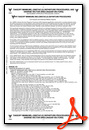
Chart Supplement

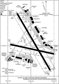
KHPN Airport Diagram
VFR Chart of KHPN
Sectional Charts at SkyVector.com
IFR Chart of KHPN
Enroute Charts at SkyVector.com
Location Information for KHPN
Coordinates: N41°4.02' / W73°42.45'Located 03 miles NE of White Plains, New York on 702 acres of land. View all Airports in New York.
Surveyed Elevation is 439 feet MSL.
Operations Data
|
|
Airport Communications
| D-ATIS: | 133.8 (914-948-0130) |
|---|---|
| ASOS: | Tel. 914-288-0216 |
| WESTCHESTER TOWER: | 118.575 284.65 |
| WESTCHESTER GROUND: | 121.825 284.65 |
| NEW YORK APPROACH: | 120.8 ;2300-0700 124.65 126.4 ;0700-2300 257.65 |
| NEW YORK DEPARTURE: | 120.55 257.65 |
| CLEARANCE DELIVERY: | 127.25 126.4 ;WHEN HPN TWR CLSD |
| VALRE STAR: | 120.8 126.4 257.65 |
| EMERG: | 121.5 243.0 |
| CTAF: | 118.575 |
| BOUNO STAR: | 124.075 133.1 343.75 |
| NOBBI STAR: | 120.8 263.0 |
| UNICOM: | 122.950 |
| RICED STAR: | 120.8 124.075 125.975 126.4 257.65 |
| D-ATIS at LGA (18.9 SW): | 127.05 ;DEP |
| ASOS at LGA (19.0 SW): | 718-672-6317 |
| D-ATIS at TEB (20.6 SW): | 114.2 |
- (ATIS DESCRIPTION) ATIS CAN ALSO BE RECD AIRBORNE VIA CMK VOR FREQ 116.6 (CARMEL).
Nearby Navigation Aids
|
| ||||||||||||||||||||||||||||||||||||||||||||||||||||||||||||


Runway 16/34
| Dimensions: | 6549 x 150 feet / 1996 x 46 meters | |
|---|---|---|
| Surface: | Asphalt / Grooved in Good Condition | |
| Weight Limits: | D-120
PCR VALUE: 537/F/B/W/T
| |
| Edge Lighting: | High Intensity | |
| Runway 16 | Runway 34 | |
| Coordinates: | N41°4.53' / W73°42.80' | N41°3.60' / W73°42.08' |
| Elevation: | 439.0 | 379.8 |
| Traffic Pattern: | Left | Left |
| Runway Heading: | 150° True | 330° True |
| Declared Distances: | TORA:6549 TODA:6549 ASDA:6549 LDA:6549 | TORA:6549 TODA:6549 ASDA:6549 LDA:6549 |
| Markings: | Precision Instrument in good condition. | Precision Instrument in good condition. |
| Glide Slope Indicator | P4L (3.00° Glide Path Angle) | P4L (3.00° Glide Path Angle) |
| RVR Equipment | Touchdown | Rollout |
| Approach Lights: | MALSR 1,400 Foot Medium-intensity Approach Lighting System with runway alignment indicator lights. | |
| REIL: | Yes | |
| Centerline Lights: | Yes | Yes |
| Obstacles: | 87 ft Building 3460 ft from runway, 600 ft right of center | |
Runway 11/29
| Dimensions: | 4451 x 150 feet / 1357 x 46 meters | |
|---|---|---|
| Surface: | Asphalt / Grooved in Fair Condition | |
| Weight Limits: | 28 /F/B/X/U, S-70, D-120, ST-120 | |
| Edge Lighting: | Medium Intensity | |
| Runway 11 | Runway 29 | |
| Coordinates: | N41°4.02' / W73°42.95' | N41°3.87' / W73°42.00' |
| Elevation: | 397.2 | 387.7 |
| Traffic Pattern: | Left | Left |
| Runway Heading: | 102° True | 282° True |
| Displaced Threshold: | 1292 Feet | |
| Declared Distances: | TORA:4451 TODA:4451 ASDA:4451 LDA:4451 | TORA:4451 TODA:4451 ASDA:4451 LDA:3159 |
| Markings: | Basic in good condition. | Basic in good condition. |
| Glide Slope Indicator | P4L (3.00° Glide Path Angle) | |
| REIL: | Yes | |
| Obstacles: | 71 ft Trees 527 ft from runway, 15 ft right of center APCH RATIO 25:1 TO DSPLCD THR. |
|
Services Available
| Fuel: | 100LL (blue), Jet-A |
|---|---|
| Transient Storage: | Hangars,Tiedowns |
| Airframe Repair: | MAJOR |
| Engine Repair: | MAJOR |
| Bottled Oxygen: | HIGH/LOW |
| Bulk Oxygen: | HIGH/LOW |
| Other Services: | AVIONICS,CARGO HANDLING SERVICES,CHARTER SERVICE,PILOT INSTRUCTION,AIRCRAFT RENTAL,AIRCRAFT SALES |
Ownership Information
| Ownership: | Publicly owned | |
|---|---|---|
| Owner: | COUNTY OF WESTCHESTER | |
| COUNTY OFFICE BLDG | ||
| WHITE PLAINS, NY 10604 | ||
| 914-995-2900 | ||
| Manager: | APRIL GASPARRI | |
| 240 AIRPORT ROAD SUITE 202 | ||
| WHITE PLAINS, NY 10604 | ||
| 914-995-4887 | ||
Operational Statistics
| Single Engine Aircraft Based on Field: | 131 | Statistics collected for 12 month period ending 2022-12-31 | |
|---|---|---|---|
| Multi-Engine Aircraft Based on Field: | 37 | Annual Commercial Operations: | 11587 |
| Jet Aircraft Based on Field: | 105 | Annual Commuter Operations: | none |
| Helicopters Based on Field: | 11 | Annual Air Taxi Operations: | 13708 |
| Military Aircraft Based on Field: | none | Annual Military Operations: | 29 |
| Gliders Based on Field: | none | Annual GA Local Operations: | 43828 |
| Ultralights Based on Field: | none | Annual GA Itinerant Operations: | 90629 |
Other Remarks
- NOISE ABATEMENT PROC IN EFCT CTC ARPT MGMT 914-995-4861.
- EQUIP AND MTRLS STAGED ADJ TO SOUTHERN EDGE OF HNGR 6 RAMP.
- FOUR DSGND HEL RTES IN USE FOR NOISE ABATEMENT.
- ATC CLNC RQRD FOR PUSHBACK ONTO MOV AREAS.
- MOWING WITHIN SAFETY AREAS OF ALL RWYS AND TWYS MAY THRU NOV.
- BIRDS & OTHER WILDLIFE ON & INVOF ARPT.
- SN REMOVAL EQUIP OPRG ON ALL ACFT MOV AREAS NOV THRU APR.
- RWY 29 CLSD TO LDG ACFT MORE THAN 12500 LBS.
- HNGR D3 RAMP ADJ TO ACTV PAX LOADING AREA AT MAIN TRML RAMP, ACFT REQSTD USE MNM THRUST AND AVOID EXCESS PWR AND JET BLAST.
- FOR CD WHEN ATCT CLSD CTC NEW YORK APCH ON 126.4, IF UNA CALL 516-683-2849.
- RWY 11/29 CLSD TO SKED ACR OPS WITH MORE THAN 9 PAX SEATS AND NON SKED ACR OPS WITH MORE THAN 30 PAX SEATS EXC FOR TAX.
- RWY 11/29 DLY CLOSURES FOR STAGING AND/OR PRKG OF SKED ACR.
- LIGHTER THAN AIR AIRCRAFT RSTRD FM OPNS AT ARPT.
- FAR 139 ARFF INDEX C IS RSTRD TO MAX. ACFT LEN OF 130 FT WHEN OPERG AT MAIN TERMINAL, GATES 1 THRU 6.
- ACFT OPRG WITH MGTOW OVR 120000 LBS MUST HAVE PRIOR PERMISSION. CTC ARPT OPNS FOR PPR LINK, CALL 914-995-4850. ALL APVD ACFT MUST CTC ARPT OPNS ON UNICOM WITH ACTUAL TKOF & LDG WTS.
- RWY 11 AIMING POINT MARKINGS.
- WHEN ATCT CLSD ACTVT MALSR RWY 16; REIL RWY 11 & 34; TDZ LGTS RWY 16; CNTRLN LGTS RWY 16/34; HIRL RWY 16/34; MIRL RWY 11/29; TWY LGTS - CTAF.
Weather Minimums
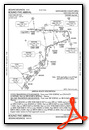
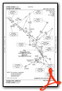
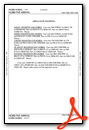
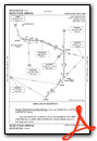
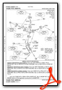
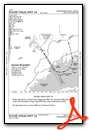
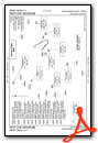
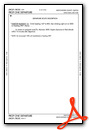
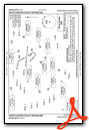
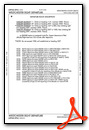
Standard Terminal Arrival (STAR) Charts
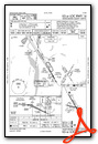
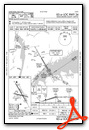
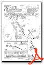
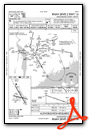
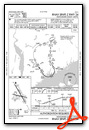
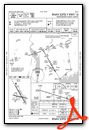
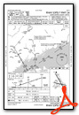
Instrument Approach Procedure (IAP) Charts
Departure Procedure (DP) Charts
Nearby Airports with Instrument Procedures
| ID | Name | Heading / Distance | ||
|---|---|---|---|---|
 |
KLGA | Laguardia Airport | 203° | 18.9 |
|
KTEB | Teterboro Airport | 231° | 20.7 |
|
KDXR | Danbury Municipal Airport | 029° | 20.9 |
 |
KJRA | West 30th St Heliport | 216° | 23.2 |
|
KFRG | Republic Airport | 146° | 24.3 |
|
KJFK | John F Kennedy International Airport | 187° | 25.8 |
|
KBDR | Bridgeport/Sikorsky Airport | 077° | 27.0 |
|
N07 | Lincoln Park Airport | 255° | 28.5 |
|
KCDW | Essex County Airport | 246° | 28.5 |
|
4N1 | Greenwood Lake Airport | 277° | 29.2 |
|
KEWR | Newark Liberty International Airport | 223° | 30.7 |
|
KSWF | New York Stewart International Airport | 325° | 31.8 |
Fuel Providers

Airport Images
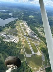
By: alikamran


Comments
Gradient Rwy 16/34 KHPN
Gradient for Rwy 34 is +0.9 (vs the displayed 0.1)
Private Jet Charter HPN
Mercury Jets - Private jet charter New York. Mercury Jets is an on-demand air charter provider specializing in private jet charter and services in New York.