Login
Register


HQU
Thomson-Mcduffie County Airport
Official FAA Data Effective 2024-04-18 0901Z
Chart Supplement

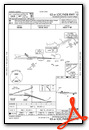
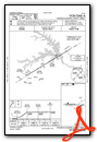
VFR Chart of KHQU
Sectional Charts at SkyVector.com
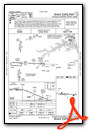
IFR Chart of KHQU
Enroute Charts at SkyVector.com
Location Information for KHQU
Coordinates: N33°31.78' / W82°31.02'Located 04 miles N of Thomson, Georgia on 260 acres of land. View all Airports in Georgia.
Surveyed Elevation is 501 feet MSL.
Operations Data
|
|
Airport Communications
| AWOS-3: | 120.625 Tel. 706-597-9801 |
|---|---|
| AUGUSTA APPROACH: | 124.45 270.3 |
| AUGUSTA DEPARTURE: | 124.45 270.3 |
| CTAF: | 122.800 |
| UNICOM: | 122.800 |
| AWOS-3 at IIY (21.2 NW): | 118.375 706-678-3647 |
| ASOS at DNL (24.2 E): | 135.275 706-481-8629 |
| ASOS at AGS (29.3 E): | 706-790-0631 |
- APCH/DEP SVC PRVDD BY ATLANTA ARTCC ON FREQS 128.1/322.325 (AUGUSTA RCAG) WHEN AUGUSTA APCH CTL CLSD.
Nearby Navigation Aids
|
| ||||||||||||||||||||||||||||||||||||||||||||||||||||||||||||


Runway 10/28
| Dimensions: | 5514 x 100 feet / 1681 x 30 meters | |
|---|---|---|
| Surface: | Asphalt in Good Condition | |
| Weight Limits: | S-30, D-50, ST-87 | |
| Edge Lighting: | High Intensity | |
| Runway 10 | Runway 28 | |
| Coordinates: | N33°31.80' / W82°31.56' | N33°31.76' / W82°30.48' |
| Elevation: | 448.5 | 501.3 |
| Traffic Pattern: | Left | Left |
| Runway Heading: | 93° True | 273° True |
| Displaced Threshold: | 299 Feet | 194 Feet |
| Declared Distances: | TORA:5514 TODA:5514 ASDA:5514 LDA:5215 | TORA:5514 TODA:5514 ASDA:5373 LDA:5179 |
| Markings: | Precision Instrument in good condition. | Precision Instrument in good condition. |
| Glide Slope Indicator | P2L (3.00° Glide Path Angle) | P2L (3.50° Glide Path Angle) |
| Obstacles: | 36 ft Trees 524 ft from runway, 494 ft left of center | 50 ft Trees 201 ft from runway, 470 ft right of center 50 FT TREES 480 FT RIGHT AT 0 FT - 200 FT FM RWY END. |
Services Available
| Fuel: | 100LL (blue), Jet A+ |
|---|---|
| Transient Storage: | Hangars,Tiedowns |
| Airframe Repair: | MINOR |
| Engine Repair: | MINOR |
| Bottled Oxygen: | HIGH/LOW |
| Bulk Oxygen: | HIGH/LOW |
| Other Services: | CHARTER SERVICE,PILOT INSTRUCTION,AIRCRAFT RENTAL |
Ownership Information
| Ownership: | Publicly owned | |
|---|---|---|
| Owner: | THOMSON CITY & MCDUFFIE CO | |
| P.O. BOX 1017 | MCDUFFIE COUNTY - 210 RAIL ROAD STREET, THOMSON, GA 30824. | |
| THOMSON, GA 30824 | ||
| 706-595-1781 | ||
| Manager: | JOHN WALLER | |
| CITY OF THOMSON, 210 RAILROAD STREET | ||
| THOMSON, GA 30824 | ||
| 706-597-7378 | ||
Operational Statistics
| Single Engine Aircraft Based on Field: | 28 | Statistics collected for 12 month period ending 2021-12-31 | |
|---|---|---|---|
| Multi-Engine Aircraft Based on Field: | 3 | Annual Commercial Operations: | none |
| Jet Aircraft Based on Field: | 1 | Annual Commuter Operations: | none |
| Helicopters Based on Field: | none | Annual Air Taxi Operations: | none |
| Military Aircraft Based on Field: | none | Annual Military Operations: | none |
| Gliders Based on Field: | none | Annual GA Local Operations: | 10100 |
| Ultralights Based on Field: | none | Annual GA Itinerant Operations: | 10050 |
Other Remarks
- DEER ON RWY AT NIGHT.
- FOR CD CTC AUGUSTA APCH AT 706-771-1777, WHEN APCH CLSD CTC ATLANTA ARTCC AT 770-210-7692.
- ACTVT PAPI RWY 10 & 28; HIRL RWY 10/28 - CTAF.
Weather Minimums

Instrument Approach Procedure (IAP) Charts
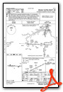
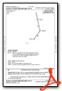
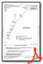
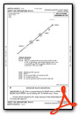
Departure Procedure (DP) Charts
Nearby Airports with Instrument Procedures
| ID | Name | Heading / Distance | ||
|---|---|---|---|---|
 |
KIIY | Washington/Wilkes County Airport | 315° | 21.1 |
|
KDNL | Daniel Field Airport | 098° | 24.3 |
|
KAGS | Augusta Regional At Bush Field Airport | 108° | 29.3 |
|
KCPP | Greene County Regional Airport | 277° | 31.4 |
|
2J3 | Louisville Municipal Airport | 168° | 33.2 |
|
KEBA | Elbert County-Patz Field Airport | 336° | 37.1 |
|
KOKZ | Kaolin Field Airport | 205° | 37.4 |
|
KBXG | Burke County Airport | 138° | 39.0 |
|
KAIK | Aiken Regional Airport | 080° | 42.3 |
|
KMLJ | Baldwin County Regional Airport | 238° | 42.8 |
|
6J4 | Saluda County Airport | 056° | 43.3 |
|
KGRD | Greenwood County Airport | 022° | 46.7 |
Airport Images
Do you have a recent image of this airport? Upload it here!


